
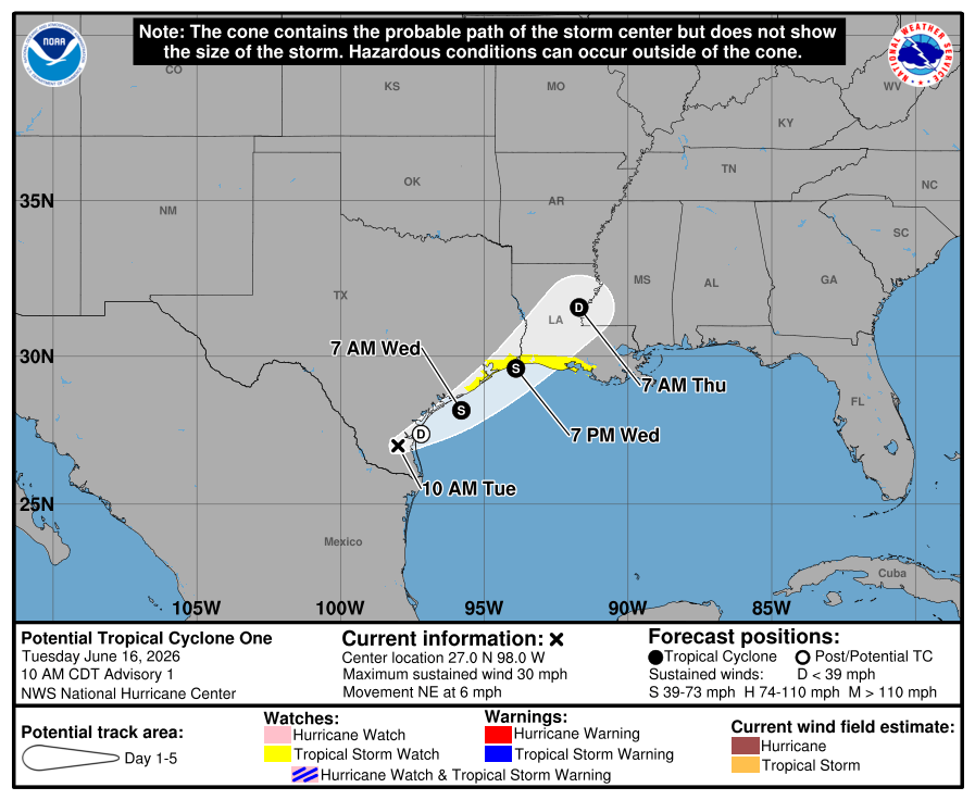
Potential Tropical Cyclone One is now being tracked by the National Hurricane Center, but let’s keep this simple: this is mainly a heavy rain and flooding setup for Texas, not a wind-driven hurricane threat.
As of 10 AM Tuesday, the disturbance was located over South Texas, about 65 miles southwest of Corpus Christi. It was moving northeast at 6 mph with maximum sustained winds near 30 mph. The system does not yet have a well-defined center, but it is expected to move back over the Gulf tonight or early Wednesday and could become a tropical storm on Wednesday as it tracks near or just offshore of the Texas coast.
That said, the name is not the story. The impacts are.
Tropical Storm Watch for the Upper Texas Coast
A Tropical Storm Watch is now in effect from Sargent, Texas, to Morgan City, Louisiana. That means tropical storm conditions are possible in the watch area, mainly within the next 24 to 36 hours.
For Texas, the highest chance for tropical storm-force wind gusts will be along the upper Texas coast, especially near the immediate coast and bays. This does not look like a major wind event for most of Texas, but gusty winds could still cause issues for high-profile vehicles, marine interests, loose outdoor items, and folks along the coast.
Heavy Rain and Flash Flooding Are the Main Problem
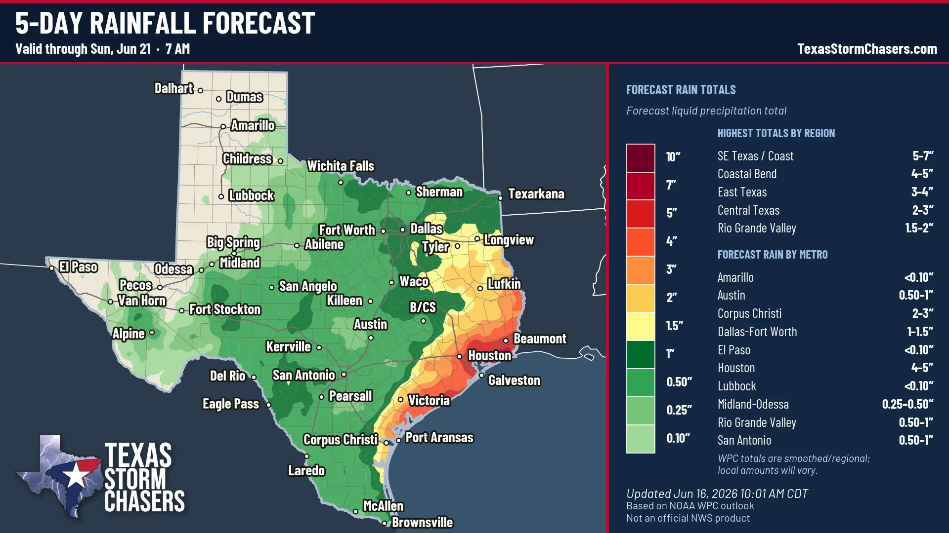
Five-day rainfall forecast through Sunday morning shows the highest totals focused along the Southeast Texas coast, Coastal Bend, and parts of East Texas.
The big concern is rainfall. The National Hurricane Center expects 4 to 8 inches of rain, with isolated totals near 12 inches, from the mid and upper Texas coast into Louisiana and points east through Thursday.
For Texas, that puts the greatest flood concern along and east of the coastal bend into the upper coast. That includes areas such as Matagorda Bay, Brazoria County, Galveston County, the Houston metro, Chambers County, Jefferson County, and nearby inland communities depending on where the heaviest bands set up.
This will not be evenly distributed rain. Tropical systems like this can produce narrow bands that sit over the same area for several hours. One town may get a manageable rain. Another may get enough to flood streets, underpasses, creeks, bayous, and poor-drainage spots.
The bottom line: do not focus only on the center track. The heaviest rain will likely be displaced east of the center.
Coastal Flooding, Rough Surf, and Rip Currents
Minor to moderate coastal flooding is expected along portions of the upper Texas and Louisiana coast. The NHC is forecasting 2 to 4 feet of storm surge from Port Bolivar eastward to Morgan City if the peak surge lines up with high tide.
That means some normally dry spots near the coast could flood, especially along vulnerable roads, low-lying coastal areas, bays, and tidal waterways.
Surf will also become dangerous along the northwestern Gulf Coast. Rip currents will be a serious issue for beachgoers over the next couple of days. This is not beach weather. Stay out of the surf.
Tornado Risk Is Low, But Not Zero
A tornado or two is possible through tonight from the upper Texas coast into Louisiana and the Deep South. This is a typical tropical setup: quick spin-up tornadoes can happen in outer rain bands, often with little lead time.
The tornado risk is not the main headline, but if you are in the upper Texas coast region, keep a way to receive warnings today and tonight.
What Texans Should Do Today
If you live along the middle or upper Texas coast, use today to clean up loose outdoor items, check drainage around your home, and make sure you can receive weather warnings. It’s already raining and has been for a couple of days. That’s what we’ll continue dealing with over the next several days.
If you flood easily, plan around that now. Do not wait until water is already over the road.
If you are traveling along the coast or through the Houston/Galveston/Beaumont region Wednesday into Thursday, build in extra time and be ready to change plans. Street flooding, slow travel, and flooded feeder roads or underpasses may become an issue where heavier rain bands develop.
Final Word
Potential Tropical Cyclone One may become a tropical storm, but the practical Texas message is straightforward: heavy rain, flooding, coastal issues, rough surf, and a low-end tornado risk.
This is not something to panic over. It is something to respect, especially if you live in a flood-prone area or near the upper Texas coast.
We’ll keep you updated as the system moves back toward the Gulf and as the rain bands become better organized.