
SAN ANTONIO – A massive, complex weather setup is gripping the nation this week, anchoring a dual threat of widespread flash flooding along the Gulf Coast and an expected outbreak of severe storms, including tornadoes, across the Midwest.
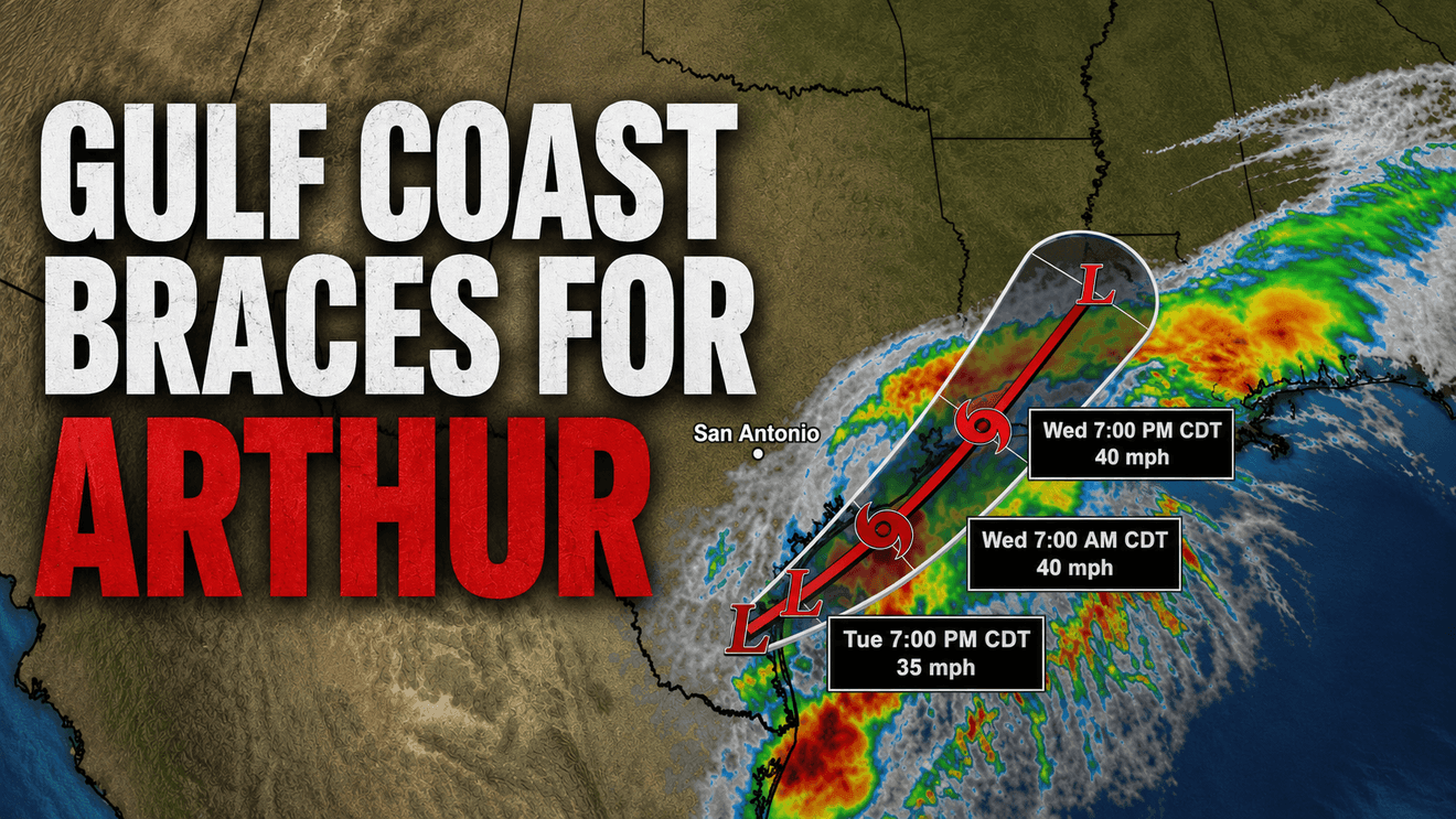
At the center of the immediate threat, the National Hurricane Center has designated a brewing system in the western Gulf of Mexico as Potential Tropical Cyclone One. The designation has triggered watches and warnings along the Texas and Louisiana coasts before a formal tropical storm takes shape.
The disturbance, previously tracked as Invest 90L, is hovering just west of Corpus Christi over northeastern Mexico. Forecasters expect the system to intensify into Tropical Storm Arthur on Wednesday morning as it tracks over the Gulf with 40 mph winds, marking the first named storm of the 2026 Atlantic hurricane season.
Meteorologists say the storm is drawing a massive plume of moisture from the remnants of the eastern Pacific’s Tropical Storm Cristina. This tropical moisture is interacting with a mid-level disturbance exiting the Mexican plateau and a cold front stalling just inland from the Gulf Coast.
The result is a prolonged, significant heavy rainfall event stretching from South Texas through the lower Mississippi Valley. Widespread storm totals of 5 to 7 inches are expected through Thursday, with localized accumulations potentially exceeding 15 inches.
The National Weather Service has placed more than 20 million people under flood watches, covering major metropolitan areas including Houston, Austin, and San Antonio.
In response, Texas Gov. Greg Abbott issued a disaster declaration for 101 counties spanning central, southern, and southeastern portions of the state, allowing local communities immediate access to state emergency resources. Abbott also ordered the Texas Division of Emergency Management to elevate the State Emergency Operations Center to 24-hour operations.
While the Gulf Coast braces for flooding, a sharply contrasting weather pattern is driving dramatic changes across the rest of the country:
Midwest Severe Weather Outbreak: A powerful low-pressure system fueled by cold Canadian air is forecast to rapidly intensify over the Northern Plains. The Storm Prediction Center has issued an enhanced-to-moderate risk of severe weather for Wednesday, warning of an outbreak of severe thunderstorms, large hail, damaging winds, and tornadoes stretching from Iowa and Illinois through the lower Great Lakes and Ohio Valley. By Thursday, the system will bring very gusty winds to the Great Lakes and push severe weather into upstate New York.
Eastern Cool Down: Behind this system, a cool and dry Canadian airmass will dominate the weather pattern across much of the eastern two-thirds of the United States, bringing a noticeable break from recent summer heat.
West Coast and Southwest Heat: On the West Coast, heat advisories remain in effect Tuesday, though temperatures are forecast to cool slightly by Wednesday. However, extreme heat will persist in the Desert Southwest and California’s Central Valley, with highs reaching the 110s and 100s, respectively.
Texas Heat Spikes: In Texas, the weather will turn highly volatile. Immediately behind the departing tropical system, a ridge of extreme heat is projected to build rapidly, bringing dangerously hot temperatures to the state on Wednesday and Thursday on the heels of the historic rainfall.
Southeast Shifting Rains: Further east, Florida will see a significant uptick in showers and thunderstorms, primarily across the northern part of the state over the next couple of days.
Residents in the western Gulf Coast are being urged to prepare for widespread flooding and localized power outages driven by gusty winds, while those in the Midwest are advised to closely monitor rapidly changing severe weather watches on Wednesday.