
Arthur has degenerated into a low-pressure area along the upper Texas coast, but life-threatening flooding was still expected to continue across portions of the southeastern U.S., according to the National Hurricane Center.Now Post-Tropical Cyclone Arthur, the storm as of 11 p.m. ET was about 85 miles west-southwest of Lake Charles, Louisiana.A northeastward motion at a faster forward speed is expected Wednesday night, followed by a turn toward the east-northeast Thursday through Friday, according to the NHC. On the forecast track, the remnants of Arthur should move farther inland over southeastern Texas and western Louisiana Wednesday night, then cross the southeastern United States Thursday through Friday.Maximum sustained winds are near 35 mph with higher gusts. The estimated minimum central pressure is 1000 mb.RESOURCES | HURRICANE SUPPLIES | SURVIVAL GUIDE | HURRICANE SEASON SPECIAL | WESH LONG-RANGE FORECAST | WHAT TO KNOW ABOUT INSURANCE | GENERATOR SETUP | TESTING CHAINSAWS | POST-STORM RESOURCES | DOWNLOAD WESH 2 APPWatches, warningsAll coastal watches and warnings are discontinued.ImpactsRainArthur is expected to produce rainfall totals of 5 to 10 inches, with isolated higher totals near 20 inches, through early Friday from the Mid and Upper Texas coast east-northeast into southern and central portions of Louisiana, Mississippi, and Alabama, along with western portions of Georgia and the Florida Panhandle. This could generate dangerous to life-threatening flash flooding.Storm surgeWater levels remain elevated along the Upper Texas coast but will continue to subside overnight.TornadoesA few tornadoes are possible Wednesday night across southeast Louisiana and southern Mississippi, and tomorrow into parts of Alabama, Georgia, and the Florida Panhandle.SurfSwells generated by Arthur are likely to cause life-threatening surf and rip current conditions along the northwestern Gulf Coast for the next day or two. Please consult products from your local weather office. Tracking the TropicsStay with WESH 2 online and on-air for the most accurate Central Florida weather forecast.RadarSevere Weather AlertsDownload the WESH 2 News app to get the most up-to-date weather alerts.The First Warning Weather team includes First Warning Chief Meteorologist Tony Mainolfi, Eric Burris, Marquise Meda, Cam Tran and Victoria Wisniewski.>> 2026 hurricane season | WESH long-range forecast>> Download Very Local | Stream Central Florida news and weather from WESH 2
ORLANDO, Fla. —
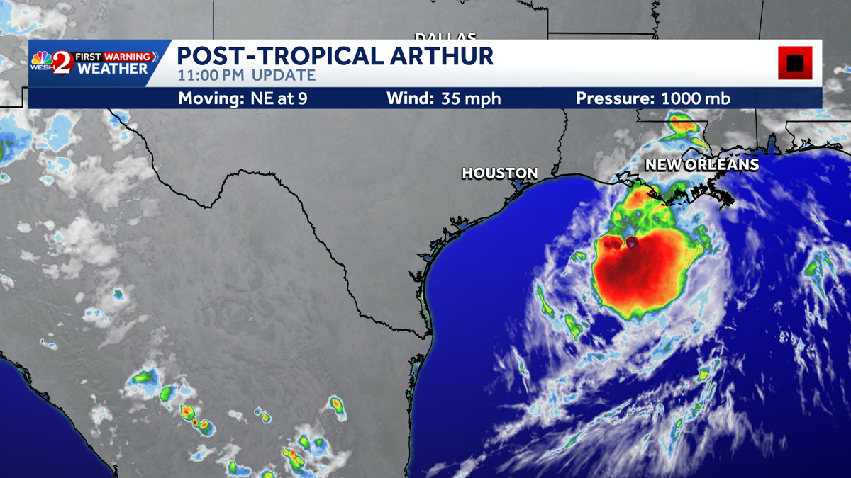
Arthur has degenerated into a low-pressure area along the upper Texas coast, but life-threatening flooding was still expected to continue across portions of the southeastern U.S., according to the National Hurricane Center.
Now Post-Tropical Cyclone Arthur, the storm as of 11 p.m. ET was about 85 miles west-southwest of Lake Charles, Louisiana.
A northeastward motion at a faster forward speed is expected Wednesday night, followed by a turn toward the east-northeast Thursday through Friday, according to the NHC.
On the forecast track, the remnants of Arthur should move farther inland over southeastern Texas and western Louisiana Wednesday night, then cross the southeastern United States Thursday through Friday.
Maximum sustained winds are near 35 mph with higher gusts. The estimated minimum central pressure is 1000 mb.
RESOURCES | HURRICANE SUPPLIES | SURVIVAL GUIDE | HURRICANE SEASON SPECIAL | WESH LONG-RANGE FORECAST | WHAT TO KNOW ABOUT INSURANCE | GENERATOR SETUP | TESTING CHAINSAWS | POST-STORM RESOURCES | DOWNLOAD WESH 2 APP
Watches, warnings
All coastal watches and warnings are discontinued.
Impacts
Rain
Arthur is expected to produce rainfall totals of 5 to 10 inches, with isolated higher totals near 20 inches, through early Friday from the Mid and Upper Texas coast east-northeast into southern and central portions of Louisiana, Mississippi, and Alabama, along with western portions of Georgia and the Florida Panhandle. This could generate dangerous to life-threatening flash flooding.
Storm surge
Water levels remain elevated along the Upper Texas coast but will continue to subside overnight.
Tornadoes
A few tornadoes are possible Wednesday night across southeast Louisiana and southern Mississippi, and tomorrow into parts of Alabama, Georgia, and the Florida Panhandle.
Surf
Swells generated by Arthur are likely to cause life-threatening surf and rip current conditions along the northwestern Gulf Coast for the next day or two. Please consult products from your local weather office.
Tracking the Tropics
Stay with WESH 2 online and on-air for the most accurate Central Florida weather forecast.
Download the WESH 2 News app to get the most up-to-date weather alerts.
The First Warning Weather team includes First Warning Chief Meteorologist Tony Mainolfi, Eric Burris, Marquise Meda, Cam Tran and Victoria Wisniewski.
>> 2026 hurricane season | WESH long-range forecast
>> Download Very Local | Stream Central Florida news and weather from WESH 2