
Arthur is now a post tropical moving inland over Texas | Tracking the Tropics
The first tropical storm of the season is now a post tropical low over Texas. Discover more about rain chances for the Carolinas and Virginia this week from Arthur’s remnants.
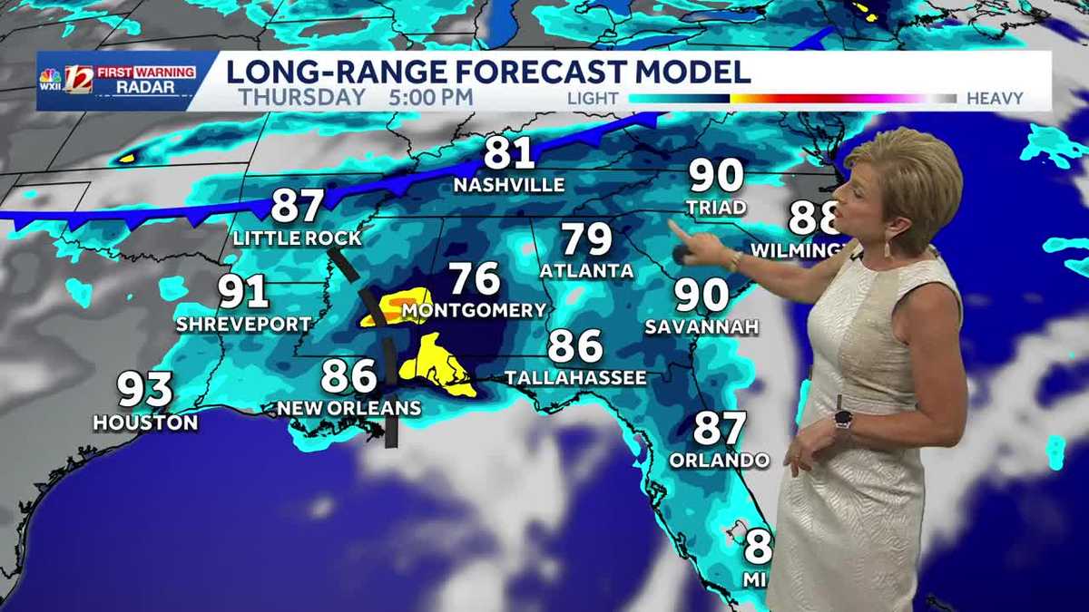
HAS BEEN BUSY TONIGHT. A LOT GOING ON. THERE’S A LOT GOING ON. FIRST, WE HAVE TO DEAL WITH THE CHANCE FOR SEVERE WEATHER TOMORROW AND THEN PERHAPS RAIN ASSOCIATED WITH WHAT’S LEFT OF ARTHUR. AS WE TALKED AT THE TOP OF THE NEWSCAST. ARTHUR IS NOW A NON TROPICAL LOW OVER TEXAS, SO VERY SHORT LIVED LIFE SPAN AS TROPICAL STORM ARTHUR. IN THE COMING DAYS WE’RE GOING TO SEE SOME CHANGES FOLKS, AS WE DO HAVE SOME HEAT AND HUMIDITY BUILDING AS WE HEAD INTO TOMORROW. AND THEN WE HAVE THAT CHANCE FOR SEVERE THUNDERSTORMS THAT WILL BE MOVING IN AFTER THAT. AND THEN SOME MUCH DRIER AIR IN TIME FOR THE HOLIDAY WEEKEND. TAKE A LOOK AT GRAHAM AND YOU WILL SEE EARLIER TODAY, LOTS OF SUNSHINE AND JUST A FEW CLOUDS. IT WAS REALLY A NICE DAY. LOW HUMIDITY, A LITTLE BIT OF A BREEZE. IT WAS A BIT WARMER THAN NORMAL, BUT FELT PRETTY GOOD OUT THERE. TEMPERATURE TOPS OUT AT 89 DEGREES. OUR AVERAGE IS 86. SO YEAH, TOMORROW I SUSPECT WILL BE INTO THE LOW MAYBE MID 90S. THESE WERE THE HIGHS ACROSS THE AREA 91 REIDSVILLE AND LEXINGTON, 87 IN MOUNT AIRY, 88 IN MARTINSVILLE, 92 IN BURLINGTON. RIGHT NOW WE’VE GOT A SEA OF 70S ACROSS THE REGION, SO IT’S WARMER THAN IT WAS THIS TIME LAST NIGHT. ALSO A TOUCH MORE HUMID WITH DEW POINTS STARTING TO CREEP UP ABOVE THAT 60 DEGREE MARK, WHERE YOU START TO NOTICE THAT THE AIR IS A LITTLE STICKY. AND WE ARE TALKING ABOUT HUMIDITY REALLY BUILDING THURSDAY AND FRIDAY, WHICH WILL ALLOW FOR SOME RAIN CHANCES AND THEN DRIER AIR AND DRIER SKIES HEADING INTO SATURDAY AND SUNDAY. OUR WINDS ARE STARTING TO TURN MORE OUT OF THE SOUTH AND SOUTHWEST. IT WILL BE A BREEZY DAY TOMORROW. SOUTHWEST OF US IS WHERE YOU HAVE ALL OF THAT HUMID AIR, AND THAT IS GOING TO BE MOVING OUR WAY. A COUPLE OF THINGS ARE HAPPENING. THIS FRONT WILL START TO WORK ITS WAY CLOSER TO US. THE MAIN THREAT OF SEVERE WEATHER WILL BE TO OUR NORTH, BUT WE’LL HAVE A THREAT AS WELL AS THAT FRONT STARTS TO DIVE SOUTHWARD. THE MOISTURE THAT’S LEFT FROM ARTHUR ALSO GOING TO BE TRACKING ACROSS THE DEEP SOUTH. SO THOSE TWO WILL SORT OF COME TOGETHER. AS FOR THE SEVERE STORM THREAT, IT WAS REALLY HIGH OUT TO THE WEST TODAY. TOMORROW WE START TO DIAL IT BACK A LITTLE BIT. SLIGHT TO MARGINAL RISK, SLIGHT RISK UP OVER THE VIRGINIAS. THAT MARGINAL RISK IS ACROSS THE CAROLINAS. A MARGINAL RISK MEANS A CHANCE FOR ISOLATED SEVERE STORMS THAT COULD IN THIS CASE, HAVE DAMAGING WINDS IN EXCESS OF 60 MILES AN HOUR. SO YOU DO SEE A LITTLE BIT OF CLOUD COVER IN HERE RIGHT NOW. WE ANTICIPATE THAT THE CLOUD COVER WILL THICKEN A LITTLE BIT OVERNIGHT. WE’LL START OFF CLOSE TO 70 DEGREES AS WE GO THROUGH LUNCHTIME. SHOULD BE PRETTY DRY. I’D SAY EARLY AFTERNOON. WE MAY SEE A SHOWER OR THUNDERSTORM, 1 OR 2 KIND OF POP UP ACROSS THE AREA. THERE’S ROOM FOR A FEW MORE. AS WE GET CLOSER TO THE DINNER HOUR, AND THEN ALSO LOOKING FOR A LITTLE MORE ACTIVITY, EVEN CARRYING LATER INTO THE NIGHT. AND SOME OF THIS COULD BE UP CLOSER TO THE VIRGINIA BORDER, COULD SEE SOME STRONG, INTENSE THUNDERSTORMS IN THAT. SAY 8:00 TO MIDNIGHT FRAME. AND THEN HERE COMES WHAT WE THINK IS THE REMNANTS OF ARTHUR, AS THEY COULD START TO WORK THEIR WAY AT LEAST A LITTLE CLOSER TO US OVERNIGHT THURSDAY INTO FRIDAY MORNING. LET’S GET THROUGH TOMORROW FIRST. REMEMBER, IT IS A BREEZY DAY, 15 TO 30 MILE PER HOUR WINDS, HIGH TEMPERATURE UP TO 93. TOMORROW AFTERNOON. WE’RE AT 91 IN THE FOOTHILLS BY LATE TOMORROW. ALSO, THAT WEATHER IMPACT FOR THE THREAT FOR SEVERE THUNDERSTORMS. THAT’S FOR EVERYONE. HIGH TEMPERATURE IN THE MOUNTAINS UP TO 83. ARTHUR. RIGHT NOW 35 MILE PER HOUR WINDS. IT’S POST TROPICAL. IT’S NOW A REMNANT LOW. AN AREA OF LOW PRESSURE WHICH DOES CARRY WITH IT A THREAT FOR RAIN. AND THAT IS WHAT WE’RE LOOKING AT WITH THIS. IT IS NOW MOVING KIND OF NORTHEAST AT ABOUT NINE MILES AN HOUR. YOU DO SEE THAT MOST OF THE CONVECTION HAS BEEN THE CASE IS OFF TO THE EAST WITH THIS STORM SYSTEM. SO ALREADY SOME OF THAT COMING ONSHORE IN LOUISIANA, FLASH FLOOD WATCHES OUT FOR THE DEEP SOUTH. THIS FRONT IS GOING TO START TO PUSH TO THE SOUTH AS THE REMNANTS OF ARTHUR ARE ALSO KIND OF CHUGGING ALONG. WHERE THOSE TWO COME TOGETHER IS WHERE YOU’RE GOING TO SEE SOME OF THE HEAVIER RAINS THERE INTO THE SOUTH. SO WE DON’T KNOW EXACTLY WHERE THAT’S GOING TO HAPPEN ACROSS THE CAROLINAS RIGHT NOW. BUT WE ARE STARTING TO BELIEVE THAT WE ARE GOING TO BE SEEING MORE OF THAT TAKING PLACE RIGHT ALONG THAT MAYBE I. 85 CORRIDOR SOUTH AND EAST, AND IT LOOKS LIKE MAINLY EASTERN SOUTH CAROLINA AND EASTERN NORTH CAROLINA CASH IN ON SOME OF THOSE HIGHER RAINFALL TOTALS. WE CAN SEE LITTLE SHIFTS WITH THIS. OF COURSE WE KNOW. SO WE’RE HOPING TO GET SOME BENEFICIAL RAIN FROM THIS. AND WE’LL OF COURSE KEEP YOU UP TO DATE OVER THE NEXT COUPLE OF DAYS AS WE TRACK WHAT’S LEFT OF ARTHUR. AND THEN ONCE THAT FRONT GETS OUT OF HERE AND ARTHUR’S OUT OVER THE SEA, YOU WILL SEE A MUCH BETTER WEEKEND. LOOK AT THAT LOW HUMIDITY. HIGHS IN THE 80S AND DRY SKIES FOR FATHER’S DAY WEEKEND.
Arthur is now a post tropical moving inland over Texas | Tracking the Tropics
The first tropical storm of the season is now a post tropical low over Texas. Discover more about rain chances for the Carolinas and Virginia this week from Arthur’s remnants.

Updated: 11:36 PM EDT Jun 17, 2026
Arthur formed in the Atlantic, becoming the first named tropical system of the 2026 Atlantic Hurricane season. Heavy tropical rain is expected along the Gulf Coast states, especially Texas, Louisiana and Mississippi, where 5-10 inches of rainfall is possible; locally higher amounts up to 20 inches are also possible. Arthur now a post tropical low inland over TexasTropical Storm Arthur has degenerated into a non-tropical low inland over Texas near Galveston. The remnants of Arthur will move northeast bringing flooding rain to the Gulf Coastal states of Louisiana, Mississippi, Alabama, and Georgia before continuing toward the Carolinas. People along the Gulf Coast should prepare for periods of heavy rainfall and flash flooding over the next several days. Gusty winds and minor coastal flooding are also likely along the northwestern Gulf Coast. Tropical Advisory and TrackArthur is likely going Tropical Radar and Latest AdvisoryTropical Spaghetti ModelsTropical forecast model track and potential rain The last named tropical system was Hurricane Melissa in 2025; the storm reached a Category 5 on the Saffir-Simpson Hurricane Wind Scale, with wind speeds of 190 miles per hour, just off the coast of Jamaica before weakening on October 31. This year’s first tropical system will be named Arthur, and it could come soon.2026 Atlantic hurricane season storm names The list includes 21 potential storm names that are chosen by the World Meteorological Association naming committee. You can find more information on the tropical weather outlook from the National Hurricane Center here in English or here in Spanish.Climate outlook for tropical activityThis year, the climate pattern known as El Niño is expected to suppress tropical systems in the Atlantic Ocean Basin. Although a slightly less active season is possible, there is no guarantee that a direct North Carolina impact won’t happen. Residents should be prepared for any coastal storm, whether it becomes tropical or whether it originates on another coast. Inland flooding and coastal storm surge are still possible even when a non-tropical system approaches North Carolina. Find out more in the story below. Hurricane Season PreparationMore weather coverage: Weather Alerts | Latest weather forecast | Post pictures to the uLocal North Carolina Facebook Group | Traffic information | Report closings and delays | SkyCams | Download the WXII12 News mobile app
USA —
Arthur formed in the Atlantic, becoming the first named tropical system of the 2026 Atlantic Hurricane season. Heavy tropical rain is expected along the Gulf Coast states, especially Texas, Louisiana and Mississippi, where 5-10 inches of rainfall is possible; locally higher amounts up to 20 inches are also possible.
Arthur now a post tropical low inland over Texas
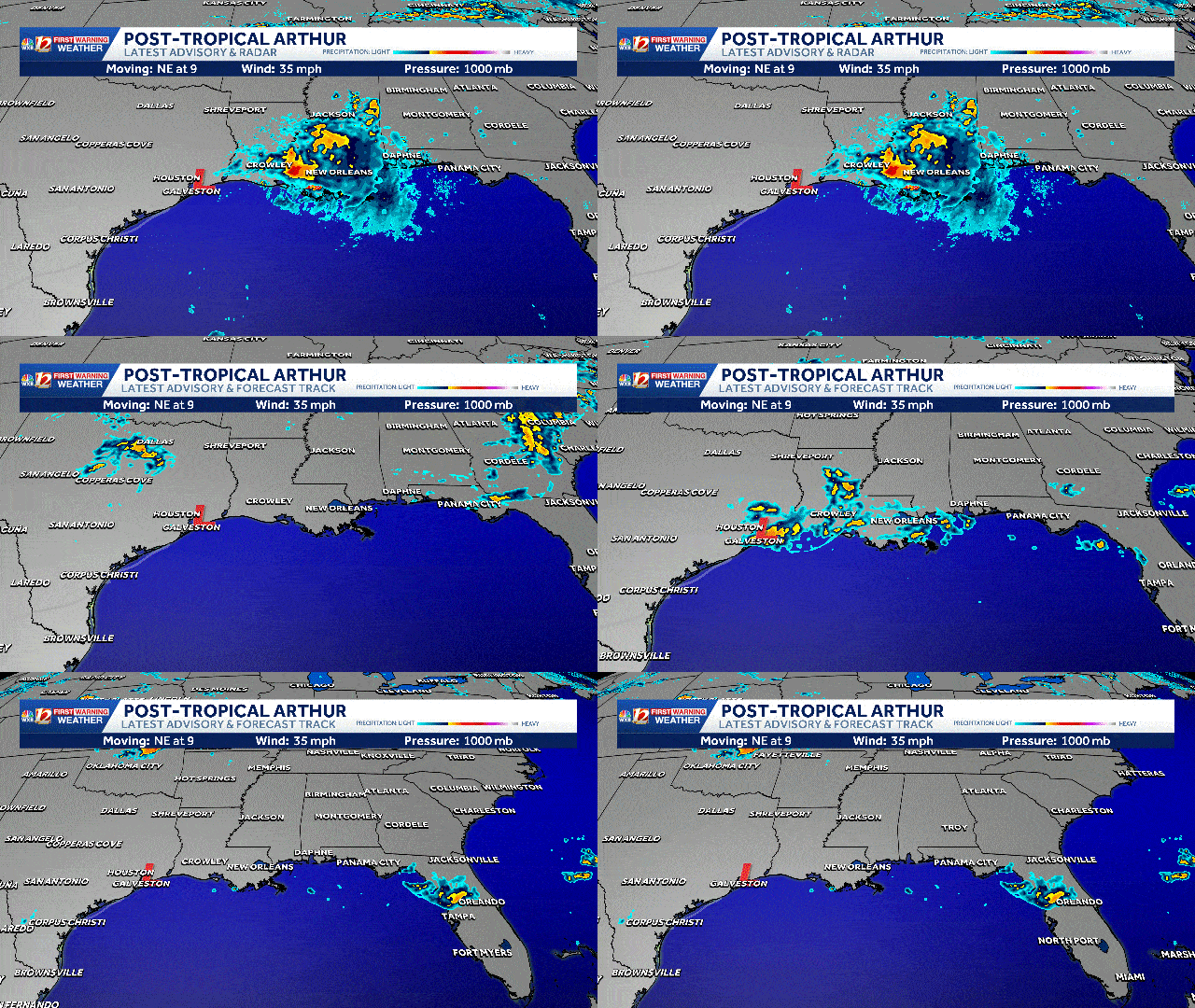
Tropical Storm Arthur has degenerated into a non-tropical low inland over Texas near Galveston. The remnants of Arthur will move northeast bringing flooding rain to the Gulf Coastal states of Louisiana, Mississippi, Alabama, and Georgia before continuing toward the Carolinas. People along the Gulf Coast should prepare for periods of heavy rainfall and flash flooding over the next several days. Gusty winds and minor coastal flooding are also likely along the northwestern Gulf Coast.
Tropical Advisory and Track
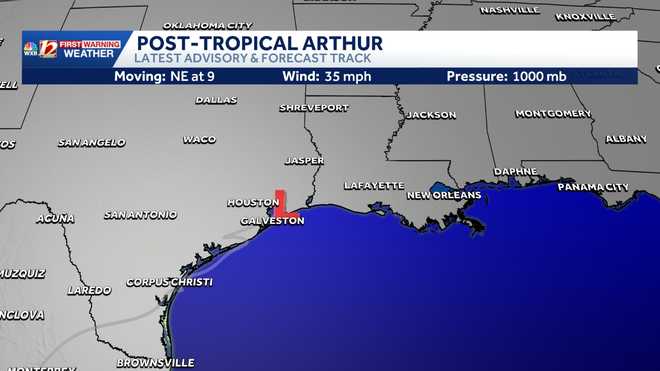
Arthur is likely going
Tropical Radar and Latest Advisory
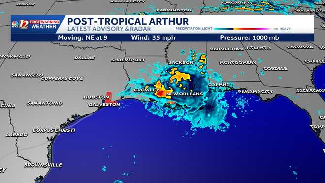
Tropical Spaghetti Models
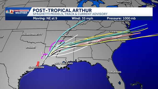
Tropical forecast model track and potential rain
The last named tropical system was Hurricane Melissa in 2025; the storm reached a Category 5 on the Saffir-Simpson Hurricane Wind Scale, with wind speeds of 190 miles per hour, just off the coast of Jamaica before weakening on October 31. This year’s first tropical system will be named Arthur, and it could come soon.
2026 Atlantic hurricane season storm names
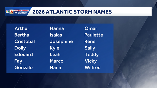
The list includes 21 potential storm names that are chosen by the World Meteorological Association naming committee.
You can find more information on the tropical weather outlook from the National Hurricane Center here in English or here in Spanish.
Climate outlook for tropical activity
This year, the climate pattern known as El Niño is expected to suppress tropical systems in the Atlantic Ocean Basin. Although a slightly less active season is possible, there is no guarantee that a direct North Carolina impact won’t happen. Residents should be prepared for any coastal storm, whether it becomes tropical or whether it originates on another coast. Inland flooding and coastal storm surge are still possible even when a non-tropical system approaches North Carolina. Find out more in the story below.
1 of 9
Latest Tropical Track and Official National Hurricane Center Forecast Track
2 of 9
Tropical Spaghetti Model Plots
This is image shows forecast spaghetti model plots for potential tropical tracks and the official National Hurricane Center forecast cone of impact.
3 of 9
Latest Tropical Track and Current Radar
4 of 9
Gulf Coast in Texas: Wind Gust Speed in Miles Per Hour
5 of 9
Gulf Coast and Southeast: Wind Gust in Miles Per Hour
6 of 9
Wave Height: Ocean Buoy Data and remote sensing data
This image shows estimated wave heights and current ocean buoy data.
7 of 9
Gulf Coast: Infrared Satellite Imagery
8 of 9
2026 Atlantic Storm Names
This chart shows the 2026 Atlantic storm names.
9 of 9
Tropical Systems Based on Wind Categories (MPH)
This chart shows the level of wind speeds in miles per hour that are needed to be categorized as a tropical system.
Hurricane Season Preparation
More weather coverage: Weather Alerts | Latest weather forecast | Post pictures to the uLocal North Carolina Facebook Group | Traffic information | Report closings and delays | SkyCams | Download the WXII12 News mobile app