
Overnight Storm Threat, Then Turning Hot and Drier
FORECAST HIGHLIGHTS
FLASH FLOODING: Multiple low water crossings closed
FATHER’S DAY: Mostly sunny, warm and humid
EXTENDED: Remaining Hot & humid
FORECAST
THIS MORNING
Rainfall rates have eased slightly across San Antonio, but not before some areas picked up more than 2 inches of rain in a short amount of time. That heavy rain has already led to Flash Flood Warnings and the closure of several low water crossings.
Storms are expected to continue through sunrise, keeping the threat for additional flash flooding in place. If you encounter water over the roadway, remember the lifesaving message: Turn Around, Don’t Drown.
THIS AFTERNOON
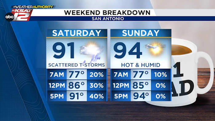
As we head into the afternoon, conditions will depend on how the atmosphere recovers from the morning rainfall. Scattered showers and storms (40% chance) remain possible through the day and into tonight.
FATHER’S DAY
By Sunday afternoon, a drying trend begins as high pressure builds east from northern Mexico into West Texas. This will gradually push rain chances out of the region and shift the focus back to summer heat.
EXTENDED OUTLOOK
Looking ahead to next week, the forecast turns mostly rain-free. Expect hot and humid conditions with highs in the mid to upper 90s and heat index values near 100 once again.
Rain chances through Saturday, then a sunny and dry stretch of weather. (Copyright 2024 by KSAT – All rights reserved.)Daily Forecast
KSAT meteorologists keep you on top of the ever-changing South Texas weather.
QUICK WEATHER LINKS
Copyright 2026 by KSAT – All rights reserved.
About the AuthorShelby Ebertowski headshotShelby Ebertowski
Shelby Ebertowski joined KSAT 12 News in January 2025. She came to San Antonio from Fargo, North Dakota via the University of North Dakota, where she learned the ropes as a weekend forecaster over two years at KVLY. Her love of weather love began after experiencing Hurricane Harvey in 2017.