
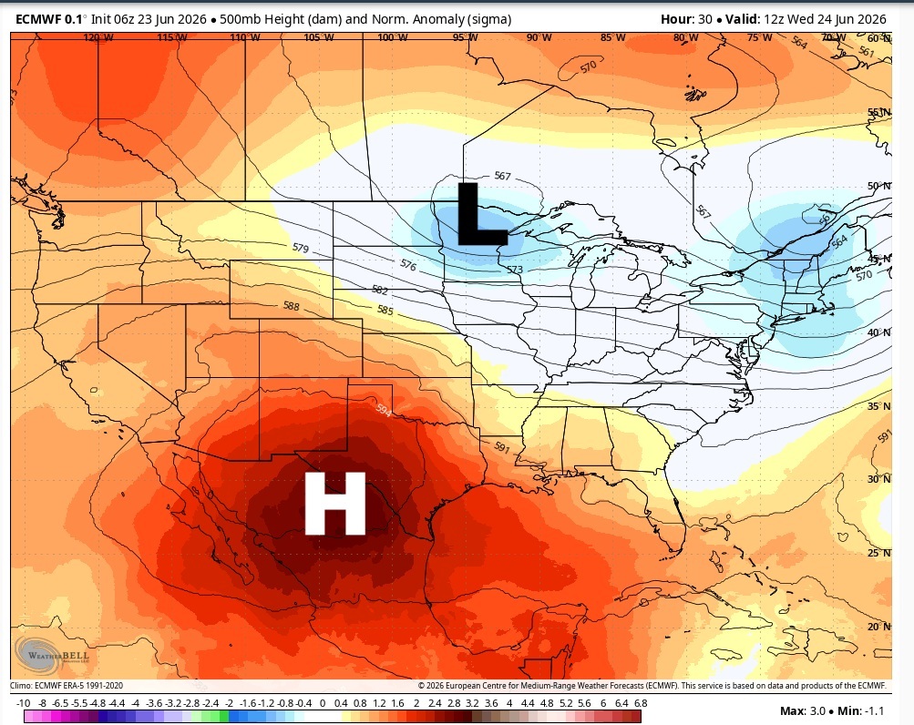
A ridge of high pressure in the upper levels of the atmosphere sits to our west and a trough of low pressure is moving toward the Great Lakes region.
WeatherBell
The summer solstice, or the start of astronomical summer, arrived just a few days ago. Instead of making a gradual transition into a typical Texas summer pattern, Central Texas seems to have jumped in headfirst. A dome of high atmospheric pressure nearby is bringing the classic summer combination of heat, humidity, morning clouds and afternoon sunshine. The only additions this week are dust, smoke and gusty afternoon winds.

What is the weather set-up?
One way to think about the atmosphere right now is as a sandwich. The top slice of bread represents the upper atmosphere, the middle of the sandwich represents the mid-levels of the atmosphere, and the bottom slice represents the Earth’s surface.
Article continues below this ad
High pressure in the Gulf will continue to keep our weather hot, humid and dry through the rest of the week. This is a look of the surface map across the southern Plains on Wednesday.
Weather Prediction Center
In the upper atmosphere, a large area of high pressure is centered over the desert Southwest. However, the system is large enough that it’s extending eastward across West Texas and into Central Texas.
Closer to the ground, where we live and experience the weather, high pressure is positioned over the Gulf while an area of low pressure sits over northern New Mexico.
Together, these systems will generate persistent southerly winds across Central Texas each day, thanks to the counterclockwise flow around the low pressure and the clockwise flow around the high pressure. Winds will be lighter during the morning before becoming breezy in the afternoon, with wind gusts of up to 25 mph.
Article continues below this ad
Hotter days with higher temperatures
Afternoon temperatures will run slightly above the late-June average of 94 degrees. However, the bigger story will be the humidity. Heat index values, or humidity-driven “feels like” temperatures, are expected to range from 100 to 105 degrees during the hottest part of the day. Overnight temps will offer little relief, falling only into the upper 70s to near 80 degrees.
The heat dome created by the high pressure out west acts like a pot lid on the atmosphere, suppressing rain chances and warm air trapped closer to the surface.
Article continues below this ad
“The large-scale weather pattern will change little through late week as the center of the mid and upper-level high pressure slowly drops southward into northern Mexico,” meteorologists at the Austin and San Antonio National Weather Service wrote in their daily forecast discussion. “While the strength of the ridge should gradually weaken, we expect to see a continuation of dry weather along with above normal temperatures across south central Texas.”
Saharan dust moves in
Like clockwork each summer, strong winds over northwest Africa lift vast amounts of desert dust from the Sahara in North Africa and carry it more than 5,000 miles across the Atlantic Ocean, through the Caribbean, and eventually into Texas along the Gulf Coast.
Article continues below this ad
A classic summertime weather pattern is settling across Texas through the end of the month, featuring a nearby dome of high pressure, building heat and humidity, and multiple rounds of Saharan dust. #txwx pic.twitter.com/waczEVqpsl
— Mary Wasson (@Mary_Wasson) June 23, 2026
Saharan dust can help suppress tropical cyclone development in the Atlantic by creating a more stable and drier atmosphere. That’s exactly what’s happening this week as a plume of dust spreads into Texas on Wednesday before another, stronger plume next week.
While the dust can lead to hazy skies, reduced air quality and aggravate allergies for some people, it also has a silver lining. The extra particles in the atmosphere often enhance the colors of sunrise and sunset, setting the stage for some spectacular evening skies through the rest of the week.