
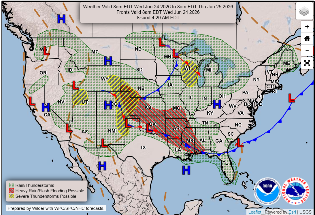
High pressure across Central and South Texas will lead to a week of near-zero rain chances. However, West Texas and the Texas Panhandle could see pockets of heavy rainfall through next Wednesday.
Pivotal
The first round of the dreaded summer doldrums has settled across much of Texas, with hot, humid and dry weather taking hold in South and Central Texas. However, in West Texas, the annual monsoon season is beginning to ramp up, and across parts of the Texas Panhandle, a stalled frontal boundary is producing pockets of heavy rainfall along with scattered strong to severe thunderstorms.
Aareas of high atmospheric pressure over the Gulf of Mexico and northern Mexico on Wednesday continue to influence the weather across Central Texas. Meanwhile, a stalled frontal boundary in North Texas and the dry line in West Texas will trigger another round of rain there through the afternoon and evening.
Weather Prediction Center

Earlier this week, the National Weather Service received around 60 severe weather reports across the state in North and West Texas.
Article continues below this ad
A severe thunderstorm near Canyon, just south of Amarillo, produced hail as large as a DVD, which shattered the windshield of a storm chaser’s vehicle.
Farther south and west, another storm produced a tornado near Fort Stockton in West Texas.
Second tornado video captured by Billy McDonald on June 22, 2026, near the Century Plant between Sanderson and Fort Stockton, Texas. pic.twitter.com/CZCgbn4bsx
— Sheriff Thaddeus Cleveland (@SheriffThad) June 23, 2026
These incident illustrate the contrast between the state’s quiet summer pattern extending from Dallas to Brownsville, and Houston to San Angelo, from the isolated areas that will still experience significant weather hazards through the rest of the week.
Article continues below this ad
Severe weather is possible in North Texas each afternoon and evening through the rest of the week.
Storm Prediction Center
Despite the lack of rain and active weather across Central Texas this week, the region will be entering the Fourth of July holiday in great shape, thanks to the recent wet weather. Austin has recorded more than 6.5 inches of rainfall in June, along with the cumulative total of 11 inches from March through May, providing a significant boost to the water levels in the Highland Lakes system on the Colorado River.
The Highland Lakes — a chain of reservoirs made from dams on the Colorado River — serves as a water supply and recreation resource for Central Texas. The two storage lakes, Lake Buchanan in Burnet County and Lake Travis in Travis County, have seen substantial improvements in water levels over the past several weeks, according to the Lower Colorado River Authority.
Article continues below this ad
Lake Buchanan, the largest reservoir in the system, is considered 100% full as of Wednesday, with its surface elevation at Buchanan Dam hitting 1,019.9 feet above mean sea level, which is about 6.58 feet above its historical June average.
Lake Travis, the largest lake in Travis County, is up to 87% full on Wednesday, with its surface elevation at Mansfield Dam as high as 672.69 feet above sea level, or about 4.27 feet above its June average.
Outside of Central Texas, other lakes across the region have had significant rise in the last month and are seeing some major changes. For instance, Medina Lake last week rose by 6 feet in just a four-day span. Since then, parts of northeastern Medina County and eastern Bandera County within the Medina River watershed received even more rainfall.
The lake now sits 8.7% full at 990.47 feet above sea level, as of Wednesday. This is Medina Lake’s highest level since August 2022.
Article continues below this ad
These healthy lake levels should provide excellent conditions for boaters, anglers and holiday travelers heading to the water for the Independence Day weekend. The rest of July looks drier than normal and warmer than normal.
However, we’ll need to keep our eyes on the tropics, especially the Gulf of Mexico for any development.
This hot, dry pattern could be with us for much of the summer. Rain chances won’t completely disappear, but storms may become more isolated rather than widespread—unless the tropics get involved. #txwx pic.twitter.com/P9OOzfJZoU
— Mary Wasson (@Mary_Wasson) June 24, 2026