
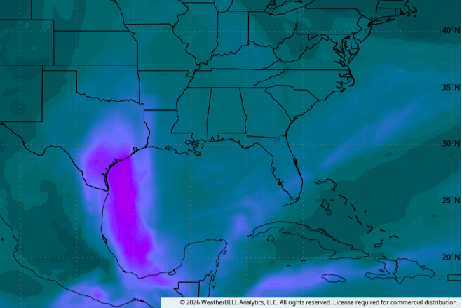
Summer heat isn’t going anywhere across Texas on Sunday as a strong upper-level ridge of high atmospheric pressure continues to dominate our weather. However, the first major plume of Saharan dust of the season for Texas is set to arrive Sunday night, spreading across the region Monday and Tuesday.
“A denser plume of Saharan dust will move inland on Monday as moisture continues to be transported into the eastern two-thirds of Texas,” forecasters with the Texas Commission on Environmental Quality said. “Fine particulate concentrations are expected to increase across most regions, although the breezier winds could promote dispersion and somewhat mitigate the effects.”
Air quality is expected to reach the “unhealthy for sensitive groups” category across South and Southeast Texas on Monday. Farther north, including Central Texas and the Dallas area, air quality will likely range from the middle to upper end of the “moderate” category.
Breezy winds will help disperse the dust more quickly but they also will carry the plume farther across the state.
For much of the upcoming week, the Lone Star State will remain locked in a classic summer setup of heat, sunshine and limited rain chances. Gusty southerly winds up to 30 mph will persist through Tuesday.
As the humidity decreases with the extra dust in the atmosphere, daytime temperatures will be a few degrees warmer than the weekend. Sunday’s high temperatures will range from 94 to 98 degrees, feeling like 100 to 104 degrees when you factor in the humidity.
The hottest day will be Monday when Austin could see our first day of triple-digit temperatures of the year. The heat will approach 100 over the next few days before backing off a bit by midweek as the heat dome caused by high air pressure shifts further east and sits over the lower Mississippi Valley.
That shift in the position of the high pressure will open the door for small changes late in the week, including increased moisture-rich air from the Gulf of Mexico. That could lead to scattered coastal showers and thunderstorms by Friday and into the Fourth of July weekend, especially across areas east of Austin.