
Shown are the expected heat index values across Southeast Texas Sunday afternoon.
Pivotal Weather
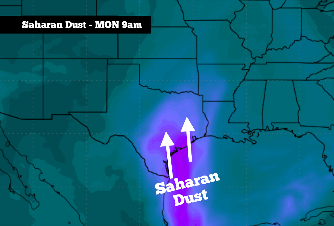
A plume of dense Saharan dust has moved into the western Gulf of Mexico, and it’s expected to continue northwest into Southeast Texas over the next 24 to 36 hours. This dust, which has traveled more than 4,000 miles from Africa, is likely to create hazy conditions in Houston starting Sunday night, likely lasting through much of Monday.
At the same time, high atmospheric pressure is also developing, which will lead to persistent near- to above-average heat across the Houston area this week. However, as high pressure shifts slightly to the east by the second half of the week, scattered rain chances could return. Here’s what you can expect.
Saharan dust is expected to start moving into Southeast Texas Sunday evening, becoming more dense by early Monday.
WeatherBell
Sunday’s forecast
Before the incoming Saharan dust becomes too noticeable, Sunday is expected to be another hot and humid day across Southeast Texas. Early morning temperatures will sit in the low 80s, rising steadily to near 90 degrees by 11 a.m.
Article continues below this ad
With bright sunshine overhead, Sunday afternoon high temperatures are expected to reach near 96 degrees in the Houston area, a few degrees above average for late June. When you factor in the high humidity, “feels like” temperatures are expected between 104 and 107 degrees across much of Southeast Texas.
Wind speeds will also turn breezy through the afternoon and evening, moving in from the south at around 15 mph. Some wind gusts could rise to 25 mph, which will help to bring Saharan dust into the area from the Gulf.
Saharan dust arrives
Light levels of Saharan dust will move into South Texas on Sunday evening after 6 p.m. This will result in hazy skies while also causing a more vibrant sunset as dust particles suspended in the air scatter sunlight.
Article continues below this ad
A more dense cloud of dust is expected to arrive overnight and into early Monday morning. This will keep skies hazy and cause worsening air quality throughout the day.
Saharan dust carries microscopic particles such as silica and quartz, which can be inhaled deeply into the lungs and trigger respiratory inflammation and irritation. It’s recommended to limit time outdoors and avoid strenuous activity. Saharan dust levels are expected to decrease by Monday night and into Tuesday.
Any rain this week?
For the early part of the week, high atmospheric pressure will dominate the weather pattern, leading to mostly sunny skies and consistent temperatures. On Monday and Tuesday, highs will be in the mid-90s, and lows will sit in the upper 70s to near 80 degrees.
Article continues below this ad
By Wednesday, high pressure is expected to shift slightly to the east. This small change may help to bring more onshore flow from the Gulf, increasing moisture levels and allowing for a few isolated showers and thunderstorms.
That said, rain is not expected to be widespread. Houston’s overall chances will be just 20% on Wednesday, rising to about a 30% chance of rain by Thursday afternoon and evening. If you do see rain, it would likely be very brief, lasting less than 30 minutes.
A few isolated showers and storms may be possible over the Fourth of July weekend. Widespread activity is not expected, so if you have holiday plans, things are still looking good to go. Temperatures will stay hot, though, with highs likely to be in the mid-90s through the holiday weekend.
Article continues below this ad