
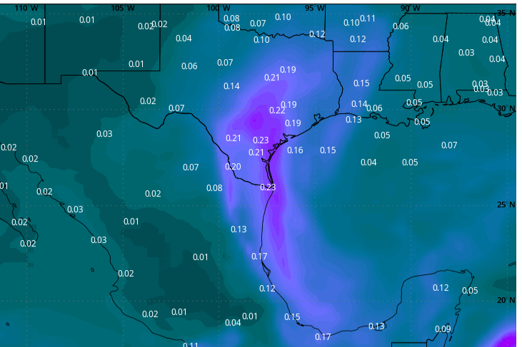
A dense plume of Saharan dust, seen here as purple and blue in this forecast model, will settle into Texas on Monday, leading to high concentrations of particulate matter in the air, according to NASA data.
Goddard Earth Observing System/NASA/WeatherBELL
While Houston’s summertime heat shows no sign of relenting, a dense plume of Saharan dust is expected to settle into South and Southeast Texas by Monday and linger in the skies over Houston through early Wednesday, according to the National Weather Service.
Although the dust will result in hazy skies and produce vibrant sunrises and sunsets this week, it also will reduce air quality significantly and could aggravate conditions for those with respiratory issues, such as asthma.
“Fine particulate concentrations are expected to increase across most regions, although the breezier winds could promote dispersion and somewhat mitigate the effects,” the Texas Commission on Environmental Quality said in its air quality forecast Sunday.
Article continues below this ad
The PM2.5 air quality index, which measures concentrations of particulate matter with a diameter of 2.5 micrometers, could reach the lower to middle of the “unhealthy for sensitive groups” range in parts of the Houston metro area, according to the TCEQ. Such particulates can be inhaled and can cause coughing, throat irritation or make breathing difficult for those with sensitive respiratory systems.
Heat index values will be in the triple digits by 3 p.m. Monday across Texas, according to the National Blend of Models, a composite weather forecast model.
National Blend of Models/Pivotal Weather
Weather this week
As we head into the final days of June, Houston continues to wither under what the weather service describes as “a moderate to major level of heat risk daily through early next week” — thanks in no small part to humidity-driven heat index values, or “feels like” temperatures, anywhere from 103 to 107 degrees (or 39 to 42 degrees Celsius for our World Cup international visitors) through Tuesday.
Although forecasters are highlighting the return of low to moderate rain chances near the middle of the coming week, don’t count on it for any noticeable relief from the heat.
Article continues below this ad
High pressure and Saharan dust
High atmospheric pressure, which tends to suppress rain chances and heat up surface temperatures, will continue to be the dominant influence on Houston weather this week.
“At the surface, high pressure over the Gulf will help maintain a persistent southerly (air) flow across the region,” the weather service said in a forecast bulletin posted online Sunday. “This will maintain warm and humid conditions over the next few days.”
Rain chances appear also to be hindered by the Saharan dust.
Article continues below this ad
“Not expecting much in the way of precip over the next few days as… an influx of drier air arrives through the day as plume of Saharan dust moves inland,” the weather service said.
Rain chances emerge closer to July 4
“As we head into the work week, the upper-level ridge axis (of high pressure) will gradually shift north and east, opening the door for a few upper-level impulses to rotate around the southern periphery of the ridge,” the weather service said.
Forecasters said they anticipate the arrival in Southeast Texas of a deep surge of atmospheric moisture from the Gulf of Mexico by midweek. Although the moisture might end up centered east of Houston, “we will see a slight uptick in rain chances, generally 20% to 40% during the afternoons from midweek through the weekend.”
Article continues below this ad
Afternoon temperatures in the Houston metro area away from the immediate coast will continue to stay in the middle to upper 90s, with little relief at night, as predawn temps fall only into the mid-70s or lower 80s.
“Peak heat indices should remain just below advisory criteria, generally 105-107 degrees,” the weather service said. “A few sites may briefly hit 108-109 during the afternoon hours.