
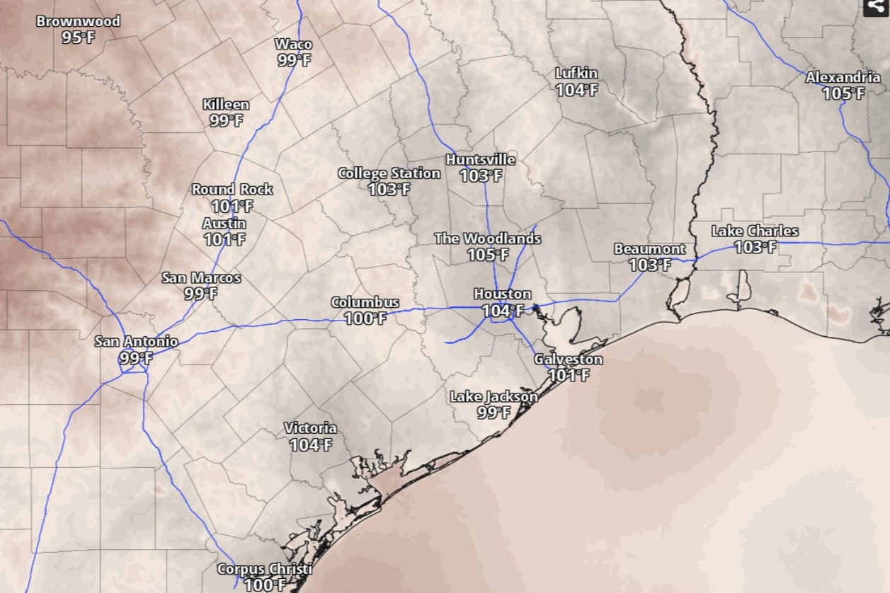
Heat index values, or humidity-driven “feels like” temperatures, will be in the triple digits across Southeast Texas by 3 p.m. Wednesday, according to the National Blend of Models, a composite weather forecast model.
National Blend of Models/Pivotal Weather
Houston weather on the first day of July finds itself in a familiar pattern Wednesday, with heat and humidity again being our main weather hazards.
Peak heat index values, or humidity-driven “feels like” temperatures will range between 102 and 107 degrees (or 39 to 42 degrees Celsius for our World Cup international visitors) with values increasing to 105 to 110 (or 40 to 43 degrees Celsius) for this weekend, according to the National Weather Service.
“We continue to monitor the forecast trend to see if heat advisories may be needed for the holiday weekend,” the weather service said in a forecast bulletin posted online Tuesday. “Frequent hydrating and shade/AC breaks will be key to beating the heat.”
Article continues below this ad
Dew points, humidity and the heat index
In Houston, dew point temperatures can help indicate how rough the summer heat will be. The dew point is essentially how cool the air has to get for dew to form, and it tends to increase with how saturated the air is with water vapor. For instance, you’ll find the air becomes uncomfortably muggy when the dew point is 65 degrees or higher. Houston dew points over the next several days will be largely between 74 and 76 degrees.
Clouds dot the skies over Southeast Texas in this weather satellite photo taken around 11:30 a.m. Tuesday. Skies will remain largely clear across the state as we head into the Fourth of July weekend.
Geostationary Operational Environmental Satellites/CIRA and NOAA
Houston on Wednesday is shaping up to be sunny, with temperatures peaking at a seasonable 95 degrees, forecasters said. But light southeast winds off the Gulf Coast will be sending in moisture-rich air that will drive heat index values 10 degrees higher to 105.
It’s this surge of atmospheric moisture that will make weather dangerous.
Article continues below this ad
On hot days, we rely on the evaporation of sweat from our skin to cool down. But high humidity makes that process less efficient because the air is already filled with water vapor. The heat index takes this into account to more accurately describe the heat the body experiences, at least better than what actual air temperatures would suggest.
Because your body’s ability to cool down is compromised, the potent combination of excessive humidity and extreme heat can become dangerous for those performing activities outside. You risk heat exhaustion or heatstroke if you don’t take adequate precautions for the heat.
If you must be outside, drink plenty of water, wear loose-fitting and light-colored clothing, and take frequent breaks in air-conditioned spaces. Also, never leave children or pets unattended in a vehicle, not even for a minute or two.
Nighttime relief from the heat will be limited this week, as overnight temperatures through the weekend will stay largely in the 80s, bottoming out around 78 degrees before sunrise.
Article continues below this ad
Rain chances near July 4
The upper-level ridge of high atmospheric pressure responsible for the uncomfortable heat in Southeast Texas has shifted northeast, forecasters said, opening the door to rain chances in the region.
“This will be accompanied by an increase in moisture moving in from the Gulf,” the weather service said. “As the moisture plume moves into our region on Thursday, shower coverage looks to increase to scattered (25-40%) along and south of I-10.”
Houston on Thursday has a 30% chance of rain in the afternoon under otherwise mostly sunny skies.
“If guidance continues to trend towards richer moisture further west, rain chances may need to be increased for the southern half of the forecast area for Thursday over the next couple of days,” forecasters said.
Article continues below this ad
Although major heat health risks are likely to increase Friday and through the Fourth of July holiday weekend, rain chances are also likely.
“The potential for hazardous heat will be closely monitored with it being the Fourth of July on Saturday,” the weather service said, adding that “we will continue with these afternoon convection/sea breeze storms through the Fourth of July weekend.”