
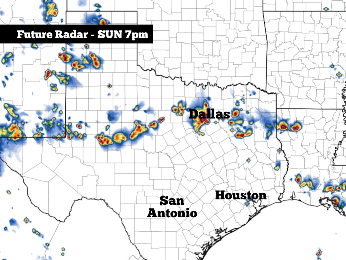
After what had been a very stormy spring across Texas, the weather pattern over the state has calmed down drastically over the past few weeks. In fact, many Texas cities – including San Antonio, Austin, Laredo, Dallas, Abilene and Houston – have not recorded any measurable rainfall since the summer solstice on June 21.
However, a slight shift in the weather pattern is expected Sunday and into Monday, as a weak low-pressure system over the Midwest will dip southward toward Texas. This change will bring scattered thunderstorms to parts of the state, particularly over the north half of Texas.
Sunday’s forecast
Locally in San Antonio, Sunday will start similarly to the past several days, with mostly cloudy skies and temperatures hovering in the mid- to upper 70s. As skies become more sunny after 9 to 10 a.m., temperatures will rise to near 90 degrees by around noon.
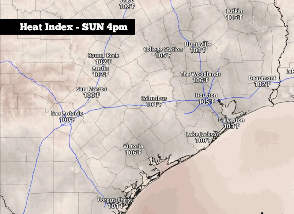
Shown are the anticipated heat index values across the region at 4 p.m. Sunday afternoon. (Pivotal Weather)
The late afternoon will bring another typical summer day, as temperatures will top out near 95 degrees in the Alamo City. Humidity will continue to be elevated, resulting in “feels like” temperatures nearing the 100-degree mark. Winds won’t offer much of a breeze, coming in at just 5-10 mph.
Texas storms develop
By the late afternoon and evening, scattered thunderstorms are expected to develop across North Texas, courtesy of a weak cold front moving across the Interstate 20 corridor.
The best chance of storms will occur across cities such as Abilene, Sherman, the Dallas/Fort Worth metroplex, and potentially as far south as Waco. In this part of the state, overall storm coverage will be at around 30%. A few storms could be strong, bringing brief downpours, frequent lightning and wind gusts up to 50 mph.
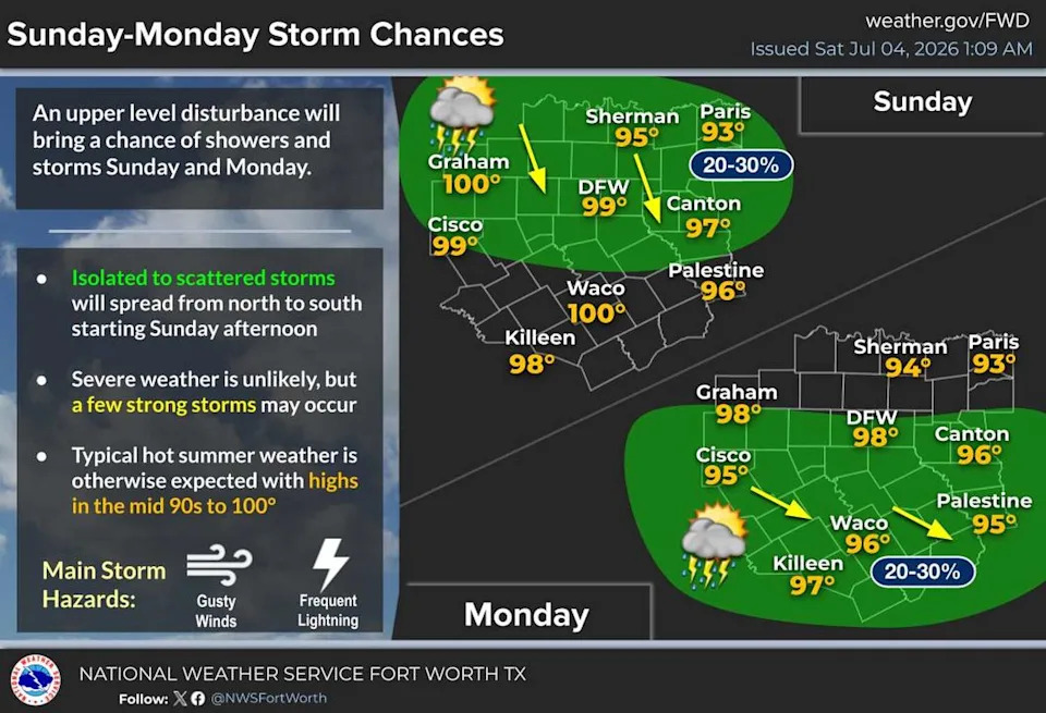
Scattered showers and thunderstorms are expected to develop across North Texas Sunday afternoon and evening. (NWS Fort Worth/Dallas)
As you push south toward Austin and San Antonio, storm chances will fall to 10% or less, keeping much of the region dry.
On Monday, lingering scattered storms are expected to form across the middle of the state, from San Angelo eastward to Waco, Killeen and Lufkin. Areas to the south, including San Antonio, will still likely stay dry, as rain chances will only be between 10% and 20%.
San Antonio extended forecast
As high atmospheric pressure generally stays situated over South Texas, San Antonio’s weather will stay remarkably consistent over the next seven to 10 days.
On Monday and Tuesday, high temperatures are expected to stay near the 95-degree mark. By Wednesday and Thursday, a slight warming trend is expected, with highs rising to around 97 to 98 degrees. Still, most of the metro area will avoid 100-degree heat.
Mostly sunny skies are expected each day this week, and there are no significant rain chances anticipated across the region. Morning low temperatures will fall into the mid- to upper 70s each day.
Long-range weather models are split on what will occur the following week, during the July 12-16 timeframe. The American GFS weather model shows that high pressure will build across Texas, allowing for widespread triple-digit temperatures. However, the European ECMWF model suggests high pressure will break down, giving way to cooler temps and higher rain chances.
Be sure to stick with expressnews.com/weather for updates as the long-range details become more clear in the coming days.
Subscribe
There’s more to San Antonio with the Express-News. Subscribe today for just 25¢.
This article originally published at Strong thunderstorms expected across parts of Texas late Sunday. Here’s where..