
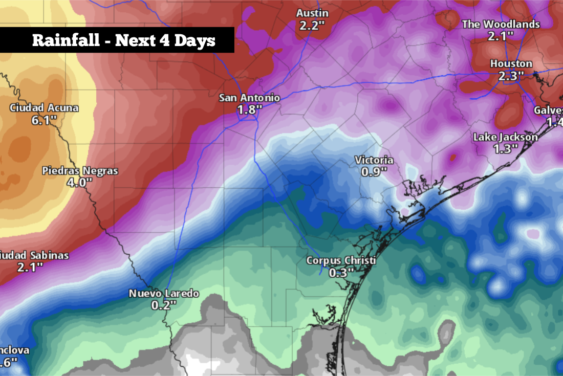
Shown are the potential rainfall totals across the region this week. Isolated higher amounts of greater than 5 inches are possible.
Pivotal Weather
Normally, by the middle of July, high pressure dominates South Texas, bringing abundant sunshine and intense heat to the region. This week, however, the pattern will look much different. High pressure will shift well to the north, allowing deep Gulf moisture to surge into the state.

The result? Daily chances of scattered thunderstorms are anticipated from Monday night through Thursday this week. Many of these storms will be slow-moving, capable of producing several inches of rain in a short period of time and increasing the threat of flash flooding. Here’s a timeline of what to expect over the next few days.
Article continues below this ad
Monday’s forecast
Before storms chances rise Monday evening, the first half of Monday is actually expected to stay dry across South-Central Texas. Early morning conditions will be mild and muggy, as morning lows hover in the upper 70s. Temperatures will rise steadily, reaching the mid-80s by 11 a.m., before topping out in the low 90s by the afternoon.
Shown are the potential heat index values across South Central Texas at 3 p.m. Monday.
Pivotal Weather
With oppressive humidity expected to stay in place, the “feels like” temperature is expected to hover near 100 degrees between 2 and 5 p.m. Monday.
Article continues below this ad
Storm Timeline
Monday afternoon (2 to 7 p.m.): A few scattered showers and thunderstorms are expected to start developing during this time. However, overall rain chances will stay on the low side, with just a 20% to 30% chance of rain in San Antonio through 7 p.m.
Monday night (7 p.m. to midnight): Rain chances will rise to around 50%, as more widespread shower and storm activity moves slowly to the south. A few storms will be strong, capable of frequent lightning, gusty winds up to 50 mph, and flooding rainfall.
Article continues below this ad
San Antonio, as well as much of the Hill Country and Interstate 35 corridor, has been placed under a level 2 of 4 risk of excessive rainfall. This means that a few spots across the region will likely encounter flash flooding.
Much of South-Central Texas has been placed under a level 2 of 4 risk of flash flooding from late Monday and into Tuesday.
NOAA
Tuesday and Wednesday: Rain chances will continue to rise through the middle of the week, with about a 60% chance of additional rainfall in San Antonio on both Tuesday and Wednesday.
The exact timing for when the heaviest rain arrives is still uncertain, but it will likely come in a few different rounds spread across Tuesday and Wednesday. Much of the region will also stay under a level 2 of 4 risk of flash flooding through the middle of the week.
Article continues below this ad
Due to the extra cloud-cover and moisture in place, temperatures will be cooler, with highs expected to top out between 85 and 88 degrees. Morning low temperatures will stay near average, sitting in the mid-70s each day.
By the second half of the week, rain chances will start to decrease. Thursday will bring a 40% to 50% chance of additional storms, while Friday’s rain chances will drop back down to 20%. A drier weather pattern is likely across the region by next weekend.
How much rain? Many forecast models, including the American GFS and European ECMWF, project that San Antonio will see between 1 and 3 inches of rain over the next five days. However, isolated higher totals could reach greater than 5 inches, which could cause flooding.
Article continues below this ad
Higher rainfall totals are expected west of San Antonio, in areas such as Del Rio, Uvalde, Rocksprings and Junction. There, 2 to 5 inches of rain is expected this week with locally heavier amounts.
Forecast changes are likely over the next couple of days. Be sure to stay with expressnews.com/weather for daily weather updates.