
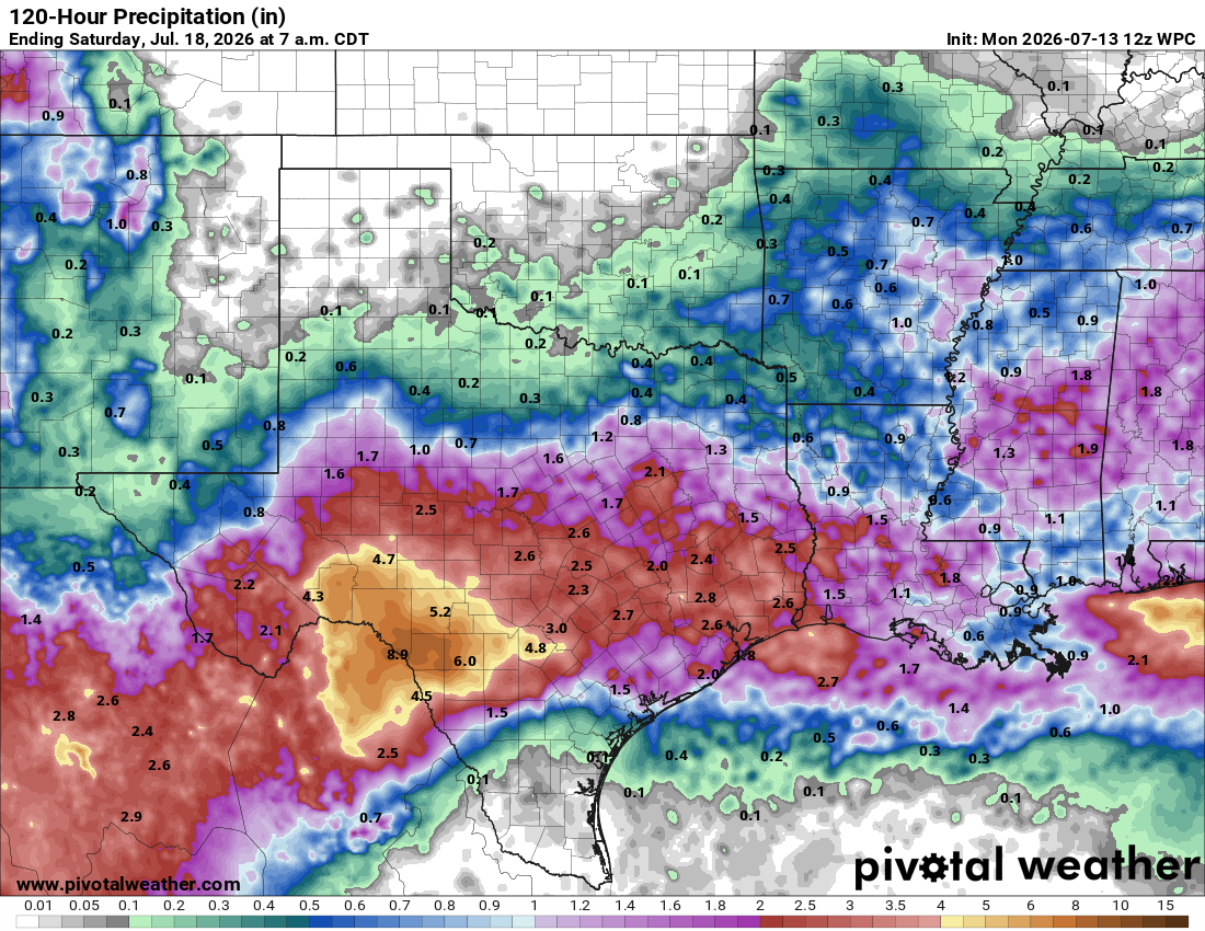
Multiple rounds of showers and thunderstorms could produce more than 2 inches of cumulative rainfall across much of the region, prompting the National Weather Service to issue a flood watch that will last through Thursday.
The increased cloudiness and rainfall will also provide a break from the summer heat, with afternoon temperatures running 5 to 10 degrees below average in the 80s for the next few days.
The heat dome, produced by a strong ridge of high atmospheric pressure, has shifted north into the northern Plains. Along the southern edge of that ridge, the clockwise air circulation is steering several slow-moving upper-level atmospheric disturbances from east to west, across a stalled frontal boundary draped over the southern United States, including Texas.
At the same time, persistent southerly and southeasterly winds are pumping deep volumes of tropical moisture into the region, providing plenty of fuel for heavy rainfall.
This weather pattern on the circulating periphery of the high pressure is referred to as the “ring of fire.” It often produces repeated rounds of showers and thunderstorms capable of torrential downpours, localized flash flooding, and occasional strong wind gusts on the outer edge of the heat dome.
While we’ll see several rounds of rain and thunderstorms from Tuesday through Thursday, the timing will be intermittent.
We’ll wake up Tuesday to overcast skies with scattered showers and thunderstorms in the Austin area. By mid-morning, more storms will develop, bringing pockets of moderate to heavy rainfall that will continue through the afternoon and into the early evening.
We may catch a brief break later Tuesday evening, but another round of showers and thunderstorms is expected to move through overnight, bringing more moderate to heavy rainfall.
“A mid-level impulse will rotate slowly around the south side of high and interact with the warm, moist air mass over South-Central Texas Tuesday night into Thursday morning,” meteorologists at the regional National Weather Service office wrote in their daily forecast discussion for Central Texas. “Rainfall totals through Thursday could be 2-6 inches with isolated (spots getting) 8 inches.”
With abundant cloud cover and frequent rounds of rain, high temperatures will be noticeably cooler. Many areas will remain below 90 degrees from Tuesday through Thursday, with afternoon temps staying below the mid-July average of 96 degrees through the end of the week.
Because flash flooding could develop overnight while many people are asleep, it’s important to make sure Wireless Emergency Alerts are enabled on your phone. These location-based alerts can warn you about life-threatening flash floods and tornadoes — even if your phone is set to silent.