
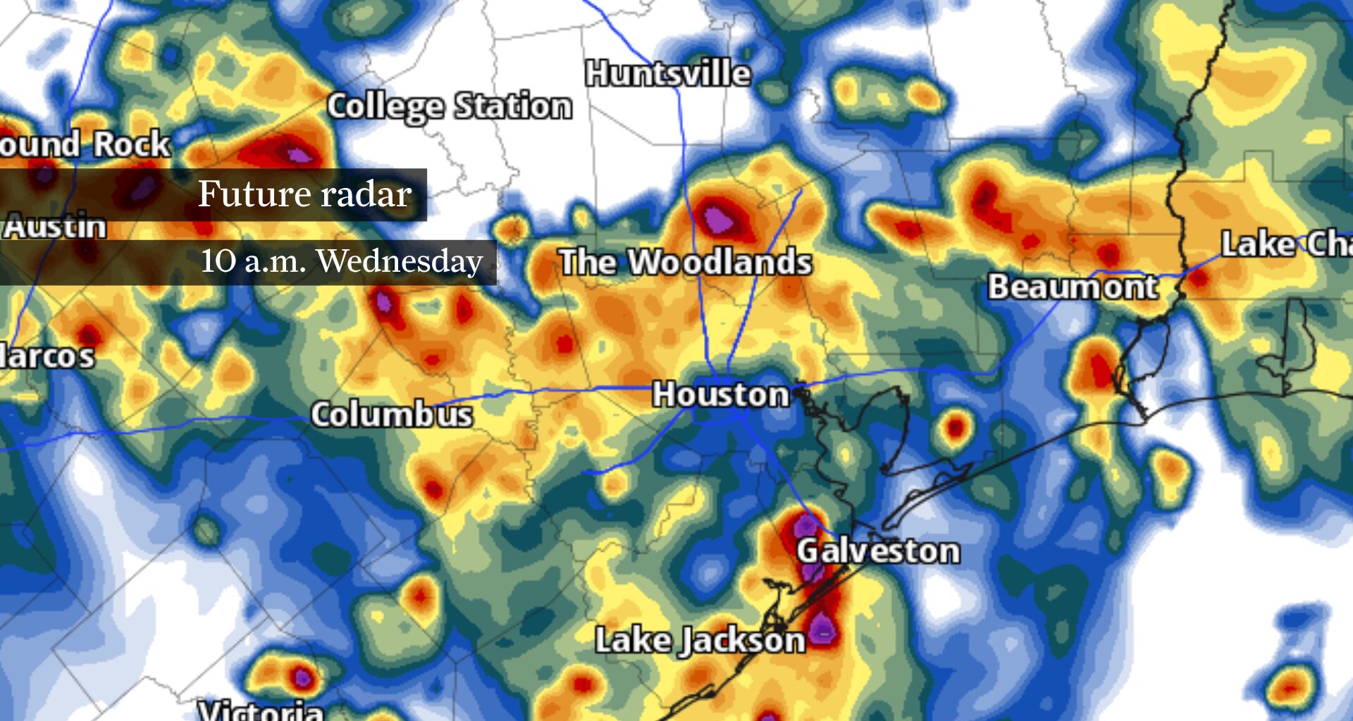
Heavy rainfall could result in localized flooding across Southeast Texas Tuesday morning, as shown by this future radar model. Storms Tuesday morning have already prompted flood alerts north of Houston.
Pivotal Weather
The Houston area’s flood threat is already underway, with slow-moving thunderstorms prompting a flood advisory for parts of Harris, Liberty, Montgomery and San Jacinto counties Tuesday morning. More heavy rainfall is expected before weather gradually improves later Tuesday.
Radar trends through 7:30 a.m. showed the heaviest rainfall stretching from Brenham east to Beaumont, with repeated downpours focused across southern Montgomery County, northern Harris County, western Liberty County and southern San Jacinto County. The heaviest rainfall rates have been occurring around The Woodlands, Cleveland, Splendora and New Caney, where storms have repeatedly tracked over the same communities.
Radar estimates and automated rain gauges indicate between an inch and 3 inches of rain have already fallen across parts of the advisory area. As of 8 a.m., more thunderstorms were continuing to develop along the same corridor, increasing the potential for localized flooding through mid-morning.
Article continues below this ad
This map shows 1-hour rainfall totals between 7 and 8 a.m. Tuesday. Rainfall totals of 1 to 2 inches per hour have prompted a flood advisory north of Houston through 10 a.m.
TexMesonet
The National Weather Service has issued a flood advisory until 10:15 a.m. for parts of Harris, Liberty, Montgomery and San Jacinto counties. The advisory says another inch to 2 inches of rain could fall before activity gradually diminishes later this morning.
While showers and thunderstorms will remain possible through the afternoon, the most widespread rainfall and greatest overall flood risk are expected in the morning.
Early morning through 10 a.m.
Article continues below this ad
This is expected to be the most active part of Tuesday.
Bands of slow-moving thunderstorms will continue producing torrential rainfall across portions of Southeast Texas, especially from The Woodlands east through New Caney, Splendora and Cleveland. Communities beneath repeated downpours will remain most vulnerable to localized street flooding through the morning.
Drivers should expect rapidly changing conditions wherever heavy rainfall develops, with localized street flooding possible in poor-drainage areas.
What to watch: More storms developing over areas that have already received heavy rainfall, especially within the flood advisory area.
Article continues below this ad
Late morning to midday: 10 a.m. to 1 p.m.
Flood risk: Moderate, decreasing to low
Rain and thunderstorms should gradually become less widespread as the morning progresses, though scattered heavy downpours will remain possible.
Communities that received several inches of rain during the morning will remain susceptible to more flooding if another storm develops overhead, even as overall storm coverage decreases.
What to watch: Slow-moving thunderstorms capable of producing another inch to 2 inches of rain in a short time.
Article continues below this ad
Afternoon: 1 p.m. to 5 p.m.
Thunderstorms should become more isolated during the afternoon as storm coverage gradually decreases.
Many neighborhoods will remain dry for much of the afternoon, but any storm that does develop will still be capable of producing brief torrential rainfall, frequent lightning and localized street flooding.
This map from NOAA’s Weather Prediction Center shows Southeast Texas under a level 2 of 4 risk, or at least a 15% chance, of flooding rainfall (area shown in yellow) Tuesday.
NOAA’s Weather Prediction Center
This map from NOAA’s Weather Prediction Center shows parts of Southeast Texas west of Houston under a level 2 of 4 risk, or at least a 15% chance, of flooding rainfall (area shown in yellow) Wednesday.
NOAA’s Weather Prediction Center
The flood threat won’t disappear entirely, but it should become much more localized than it was during the morning commute.
Article continues below this ad
What to watch: Isolated slow-moving storms that briefly reduce visibility and create pools of water on roadways.
Evening: After 5 p.m.
Most showers and thunderstorms should gradually fade during the evening, allowing any remaining flooding issues to improve.
Rain chances continue Wednesday, although storm coverage is expected to be lower before a more typical July weather pattern of heat and humidity returns later this week.