
LUBBOCK, Texas (KCBD) – You may not have noticed, but high temperatures the past few afternoons have come in slightly below the average for the time of year. The humidity, on the other hand, continues somewhat above our average levels. So it may not seem like there’s much relief from the heat. For context, Lubbock’s July 14 average high is 93°. The record high for the date? That’s 111° (set six years ago).
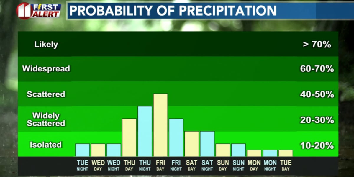
The pattern of the past few days continues tomorrow, then a wetter but brief pattern is expected to end the week.
Tonight
Following a few thundershowers in the early evening, mainly southeast of Lubbock, tonight will be mostly clear with lows dropping into the 60s. That’s just slightly below average for mid-July. This might be the best night in a while to sleep with windows open if you’re so inclined.
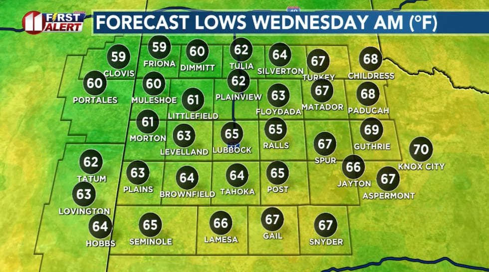 Wednesday morning forecast low temperatures.(KCBD First Alert)
Winds will be light from the east, diminishing to around 5 mph after midnight.
On Repeat
Wednesday will start off much like recent mornings, a few clouds in the morning, then mostly sunny with partly cloudy skies returning in the afternoon. Rain chances will be quite slim around Lubbock and across the viewing area north of Lubbock. There’s a little better chance of storms and rain over the southern KCBD/FOX34 viewing area.
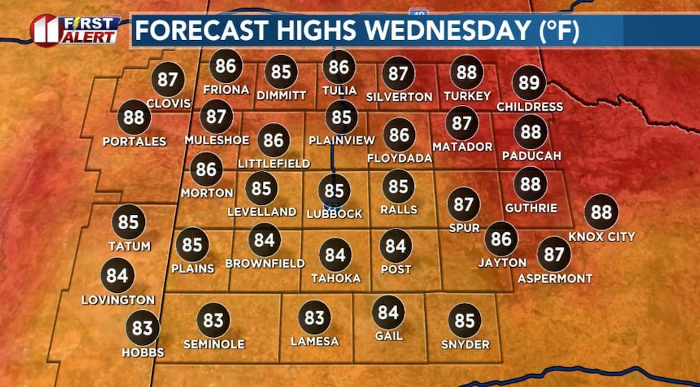 Below average high temperatures continue Wednesday.(KCBD First Alert)
Temperatures will peak in the 80s, around eight degrees below average for the date.
Winds will be light through the morning with a slight breeze developing during the afternoon.
Pattern Change
A weak weather system (an upper-level disturbance) is forecast to move north out of South Texas, bringing plentiful tropical moisture to the South Plains area. This will set the stage for our most significant rain chance late Thursday through Friday.
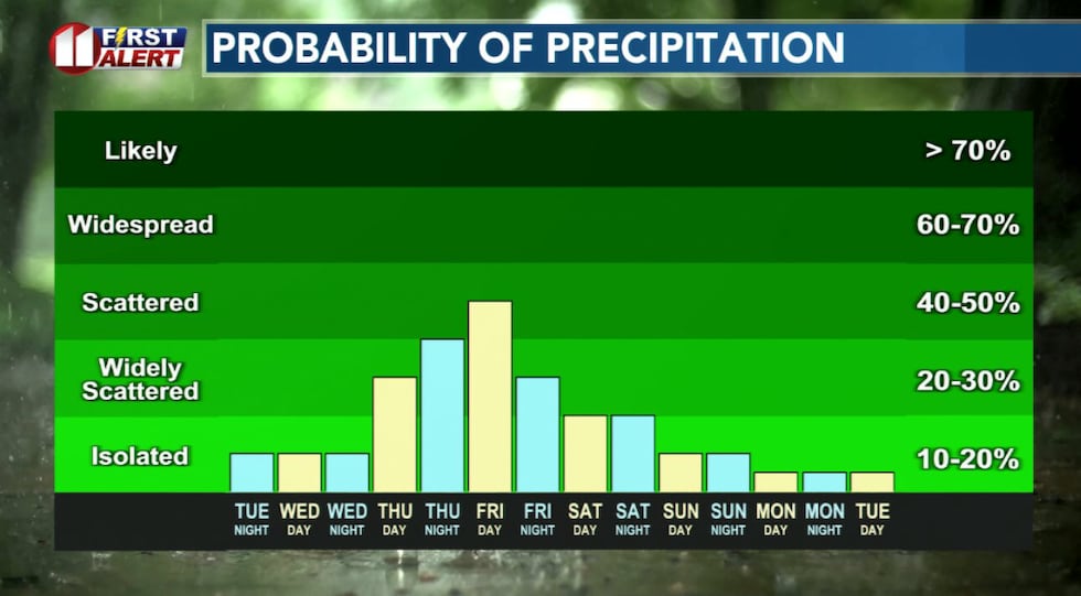 Lubbock rain chances remain low through early Thursday, then increase late Thursday through Friday.(KCBD First Alert)
Showers and thunderstorms are expected to develop Thursday afternoon and into the evening. The atmosphere will be nearly saturated and steering winds weak, so storms that develop will be efficient rain makers and slow moving. Localized flooding is a concern. Watch for weather alerts which may be issued and watch for possible flooding of roads, especially at night when the danger is more difficult to detect.
Wettest Period
Friday may be even wetter. Showers and thunderstorms may be around in the morning with more in the afternoon. This is our highest rain chance of the week. With the ground already moist from earlier activity, any heavy downpour may result in localized flooding, especially in areas that see repeated storms.
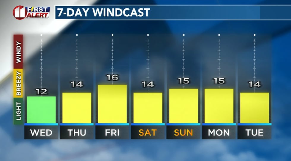 Forecast daytime sustained wind speeds for the Lubbock area. Occasional greater gust speeds are expected. Much stronger gusts from thunderstorms are possible.(KCBD First Alert)
Changing Again
The wet pattern will begin to wind down Saturday as the upper-level disturbance shifts westward. We’ll see mostly sunny skies with just a slight chance of afternoon and evening showers and thunderstorms.
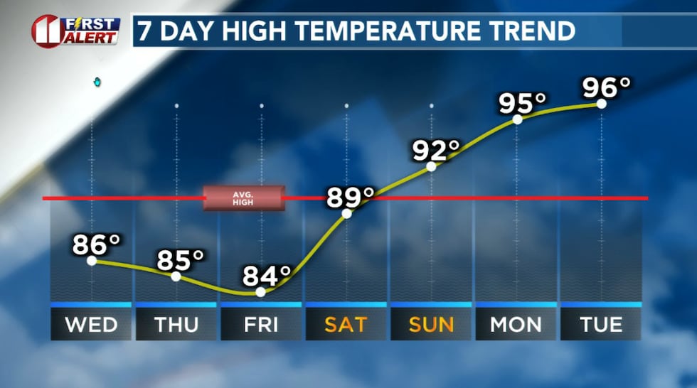 Below average high temperatures through Saturday.(KCBD First Alert)
Temperatures will remain below average through Saturday, but a gradual warming trend under a mostly sunny sky will take highs to near average Sunday and slightly above Monday.
Next Week
Current data points to a hotter and drier pattern next week.
 Check it out at sciencespectrum.org!(KCBD First Alert)
On This Date
On this date in 1961, a farm house, two vehicles, and several outbuildings were heavily damaged by a tornado late in the evening near Parnell in Hall County. The tornado bounced along the ground for about five miles. Several other storms produced damaging hail that, in some cases, wiped out thousands of acres of crops throughout Hall, Floyd, Swisher, Hale, and Hockley Counties.
(Source: National Weather Service, Lubbock)
Copyright 2026 KCBD. All rights reserved.