
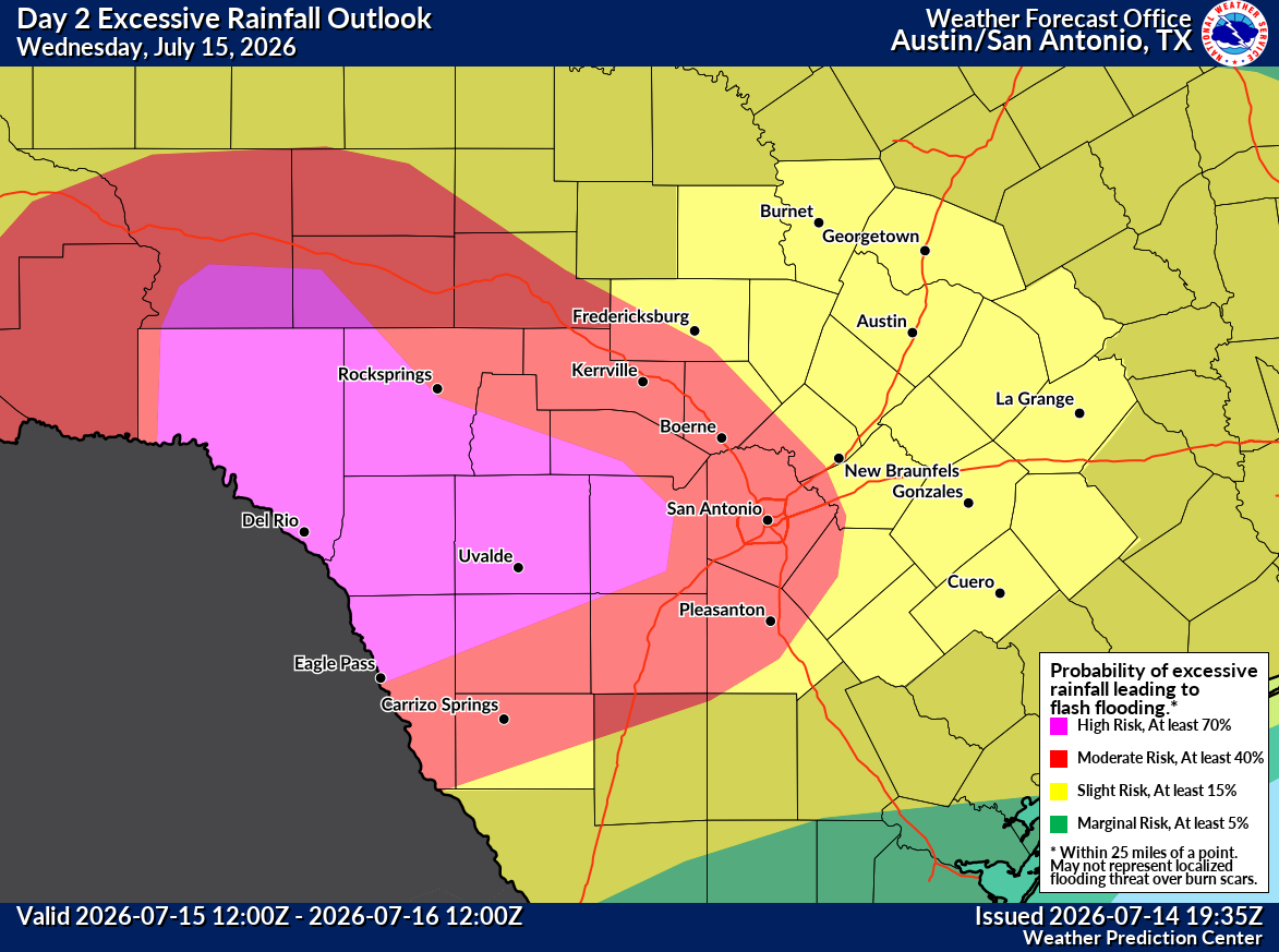
A rare level 4 risk of excessive rainfall has been posted for the southern Hill Country and Rio Grande Plains on Wednesday. Isolated rainfall totals of up to 20 inches or more are possible.
NWS Austin/San Antonio
A major flood event may unfold across South Texas Wednesday as a surge of tropical moisture interacts with a strengthening low-level jet stream. Torrential downpours will be possible for many, with isolated rainfall totals of 10 to 20 inches possible in a few locations.

A level 4, or “high,” risk of excessive rainfall has been issued by the National Weather Service’s Weather Prediction Center for areas west of San Antonio, including cities such as Hondo, Uvalde, Bandera and Del Rio. A high risk is extremely rare, occurring only once every few years across South-Central Texas.
Article continues below this ad
“Considerable to locally catastrophic flash flooding impacts are likely for portions of the U.S. 90 corridor west of San Antonio, including the southern Edwards Plateau and Rio Grande,” the National Weather Service said in a statement on Tuesday.
A significant flash flood threat also extends into the San Antonio metro area, the Hill Country and much of the Interstate 35 corridor. Here’s what to expect.
Major flood threat
Widespread thunderstorm activity is expected throughout South-Central Texas early Wednesday, with overall rain chances rising to around 90% in San Antonio between 6 a.m. and noon. Many of these storms will be strong, producing frequent lightning, damaging wind gusts and prolonged, torrential downpours.
Article continues below this ad
Shown is the potential radar for 9 a.m. Wednesday, as widespread morning thunderstorms are expected to slowly move over South Texas.
Pivotal Weather
Rainfall rates could exceed 4 inches per hour at times — enough to trigger dangerous flash flooding in as little as 30 minutes.
How much rain will fall? The heaviest rainfall is expected across the Rio Grande Plains and southern Edwards Plateau, where widespread totals of 3 to 7 inches are forecast. However, isolated totals of 10 to 20 inches are possible where thunderstorms repeatedly move over the same locations.
In San Antonio, most areas are expected to receive 2 to 6 inches of rain, while isolated higher totals approaching 10 inches or more are also possible.
Article continues below this ad
Thunderstorms may persist into the early afternoon before becoming more scattered later in the day. Rain chances in San Antonio are expected to fall below 40% after about 4 p.m., although isolated strong storms will remain possible through the evening.
Shown are the potential rainfall totals across South Texas through 6 p.m. Wednesday, according to the High-Resolution Rapid Refresh weather model. Isolated rainfall totals of up to 20 inches will be possible in a few spots.
Pivotal Weather
“Potential impacts include flooded/impassable roads, flooded creeks/streams, and potential inundation of homes,” the weather service said. “Please have a reliable means of receiving weather warnings and information from local/state officials.”
Be sure that Wireless Emergency Alerts are enabled on your phone. These location-based alerts can warn you about life-threatening flash floods even if your phone is set to silent.
Article continues below this ad
Because of the heavy rainfall in the area, temperatures on Wednesday will be significantly below average, likely topping out only in the upper 70s to low 80s in San Antonio.
More flooding possible
More showers and thunderstorms are expected to redevelop Wednesday night and last through early Thursday morning. Some of the same areas that receive heavy rainfall Wednesday morning could pick up several more inches of rain, worsening ongoing flooding concerns.
Rain chances will start to decrease across the region by Thursday afternoon and evening. However, yet another round of heavy rainfall will be possible late Thursday night and into Friday morning. Be sure to stay with expressnews.com/weather for continued severe weather updates.
Article continues below this ad
Drier weather finally returns
Forecast models indicate a much quieter weather pattern will develop over the weekend, with just a 10% to 20% chance of new rainfall Saturday and Sunday. Instead, San Antonio will likely see partly or mostly sunny skies, with afternoon temperatures rising back into the lower 90s.
Humidity values will remain extremely high, however, partly because of the heavy rainfall expected throughout the week. This could push heat index values, or “feels like” temps, past 105 degrees at times.
Article continues below this ad
Mostly dry weather is expected to continue through much of next week, with peak daytime temperatures remaining in the lower to mid-90s. While a few isolated showers or thunderstorms remain possible by the middle of the week, more flooding is not expected for now.