
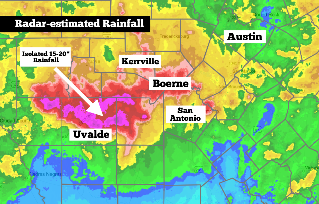
Shown is the radar estimate rainfall across the region from 3 p.m. Monday through 3 p.m. Wednesday. Parts of Uvalde county saw up to 15-20 inches of rain.
NOAA
Very heavy rainfall has inundated parts of South-Central and Southwest Texas over the past two days. Since Monday, parts of Uvalde and Medina counties have received up to 20 inches of rain or more — more than 50% of the area’s average annual rainfall.

Major flooding continued into Boerne, where parts of southern and eastern Kendall County have received 5 to 12 inches of rain. Rainfall totals have been lower in San Antonio, with rainfall totals ranging between 2 and 5 inches across much of the metro area since Sunday night.
Article continues below this ad
Unfortunately, yet another round of heavy rainfall is already underway across parts of the region Thursday, especially for areas west of San Antonio. Flash flood warnings stretch from Uvalde County northward into much of the Hill Country, including Kerrville and Fredericksburg. And a flood watch is still in place for the entire region until at least 7 p.m. Thursday evening.
The Weather Prediction Center has assigned a level 3 of 4 risk of excessive rainfall for parts of the Edwards Plateau and Hill Country on Thursday, as another round of rainfall moves into the region.
NOAA
Where is the highest chance of flooding?
Early Thursday morning, a cluster of strong and slow-moving thunderstorms are expected to develop in some of the same areas that have already experienced torrential rainfall. This includes the Hondo and Uvalde area, northward into the Edwards Plateau and Hill Country.
Article continues below this ad
This region — which also includes Kerrville, Bandera, Leakey, Rocksprings and Junction — is under a level 3 of 4 risk of excessive rainfall on Thursday. Those in this risk level are expected to receive another 3 to 7 inches of rain, with isolated totals of greater than 12 inches possible.
The highest chance of rain will occur between 2 a.m. and 11 a.m. Thursday. However, scattered thunderstorms are still likely to move across the Hill Country and Edwards Plateau into the afternoon as well.
Widespread flooding is expected across this corridor, especially in the cities of Uvalde, Kerrville, Medina, Utopia, and Fredericksburg.
Shown is the potential future radar across the region at 8 a.m. Thursday morning.
Pivotal Weather
San Antonio forecast
Overall rain chances will be lower in the Alamo City, but a significant threat still exists. Scattered thunderstorms are likely to move across Bexar County in the morning, with drier weather likely by the second half of the day.
Article continues below this ad
Overall rain chances in the Alamo City will be around 50% to 60% during the morning, especially between 6 a.m. and noon. By the late afternoon and evening, a few isolated storms are still possible, but rain chances will decrease to around 30%.
San Antonio is under a lower level 2 of 4 risk of excessive rainfall on Thursday, meaning that while flooding is not expected to be widespread across the city, some areas could still flood. North and western parts of Bexar County have a slightly higher flood risk.
Once again, temperatures will be below average across the region, as plenty of clouds stick around. San Antonio will likely see temperatures top out in the mid-80s, while much of the Hill Country will stay in the upper 70s to lower 80s.
Article continues below this ad
One more round possible
Another cluster of thunderstorms is expected to develop late Thursday night and into early Friday morning. This cluster is expected to stay a bit farther west, with areas such as Del Rio, Rocksprings, Junction and Sonora with the highest chance of heavy rainfall and flooding.
Minor accumulations are still possible Friday morning in Uvalde County. Farther east, rain chances will be much lower, with just a 20% chance of new rainfall in the San Antonio metro area.
Article continues below this ad
Rain chances are expected to continue falling over the weekend, allowing the region to finally dry out. San Antonio can expect partly cloudy skies both Saturday and Sunday, with only a 10% chance of an isolated storm. Temperatures will stay below average for July, topping out in the lower 90s.