
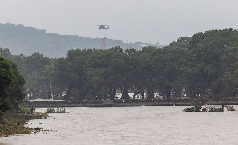
The Guadalupe River at Center Point rose 32 feet in 4 hours and is forecast to crest near levels seen during the catastrophic July 4, 2025, flood.
Published Jul 15, 2026 1:38 PM EDT
|
Updated Jul 17, 2026 9:48 AM EDT
Flash flooding has caused intense damage to the Buckhorn Lake Resort in Texas on July 16. Storm chaser Jonathan Petramala was in the city of Ingram where a highway got scoured by river flooding.
A flash flood emergency unfolded in the Texas Hill Country on Thursday, where multiple rivers surged to major flood stage within hours, creating a life-threatening situation.
The Guadalupe River gauge at Center Point rose 32 feet in just four hours, according to gauge data. Forecasters said the river is expected to crest at a level similar to the catastrophic and deadly July 4, 2025, Guadalupe River flood. The warning covers communities along the river corridor west and northwest of San Antonio, including Kerr County and Kerrville, where residents are being urged to seek higher ground immediately and avoid flooded roads.
The Guadalupe River crested at 37.08 feet at Comfort around 8 a.m. CDT, surpassing the historic crest at 35.64 feet from July 4, 2025.
Rescue helicopters fly over the flooded Guadalupe River on Thursday, July 16, 2026, in Kerrville. (Andrew J. Whitaker/San Antonio Express-News via Getty Images)
At least two people have died due to the flooding, according to The Associated Press. Emergency crews have used helicopters and boats to rescue over 200 people from high water.
Kerrville Mayor Joe Herring Jr. said the Guadalupe River levels he has seen this week are even higher than they were during the July 4, 2025, flood.
Herring said he had not confirmed any fatalities in Kerrville as of Thursday morning, but he was concerned about what news may emerge later. The mayor said he hoped the new warning systems put in place before summer worked as intended.
“This time was different, in that with the help of the state and the Upper Guadalupe River Authority, we had more warning,” Herring said.
Another flash flood emergency was issued for areas along and near the Pedernales River through Gillespie and Blanco counties.
“A large and deadly flood wave is moving down the Pedernales River,” the National Weather Service office in San Antonio warned.
A green ribbon in remembrance for the July 4th flood is seen while the Guadalupe River floods on Thursday, July 16, 2026, in Kerrville. (Andrew J. Whitaker/San Antonio Express-News via Getty Images)
The emergency comes as South Texas remains under a dangerous, prolonged flood threat following rounds of slow-moving storms that have already triggered evacuations and water rescues in parts of the Hill Country and the Uvalde area. AccuWeather meteorologists said widespread, life-threatening flash flooding is expected in south-central Texas through at least Friday, with catastrophic river flooding and rapid rises possible on streams, arroyos and normally dry washes in the Texas Hill Country.
Floodwater engulfs Rodeo Los Corrales Dance Hall in Comfort on Thursday, July 16, 2026, after heavy rain sent the Guadalupe River surging more than 30 feet in about three hours. (Ricardo Delgado/San Antonio Express-News via Getty Images)
AccuWeather Chief Meteorologist Jon Porter said Thursday morning’s catastrophic flooding along the Guadalupe River, especially in Kerr and Kendall counties, has some key differences from the deadly July 4, 2025, flood, and those differences may have expanded the danger zone.
“In both cases, extreme rain rates of 2-4 inches per hour or even higher rates resulted in excessive water runoff into creeks, streams, the Guadalupe River and other waterways,” Porter said, adding that both events produced rainfall totals near a foot in just a few hours, causing water levels to rise rapidly.
But Porter said the rainfall footprint appears to be different this time. During the July 2025 flood, the heaviest rain fell mainly over steep, less populated terrain west of Hunt, Texas, producing a deadly flood wave that raced down the Guadalupe River. While areas such as Ingram and Kerrville saw some flooding then, the worst impacts were largely near the river.
By contrast, preliminary data from Thursday’s event shows the heaviest rain spread across a wider area, with totals near a foot indicated in Ingram and Kerrville. Porter said that likely produced not only another destructive flood wave on the Guadalupe River, but also more widespread flash flooding on creeks, streams and other waterways.
“People who did not see flash flooding impacts from the July 2025 flood may have been impacted by major flooding during this extreme rain event,” Porter said.
A tornado caused significant damage across parts of San Antonio on July 15, toppling trees, damaging structures and leaving a trail of destruction in its wake.
On Wednesday, a tornado damaged parts of northwestern San Antonio as rounds of severe storms and flooding continued to pound Texas.
The San Antonio Fire Department said crews were on scene at 6023 UTSA Boulevard and were assessing multiple properties at The Rim after a tornado touched down. No injuries had been reported, according to the city.
A tornado spotted at I-10 and the 1604 Loop in San Antonio on Wednesday, July 15, 2026. (Image credit: Mollee Herrera/Bracken Collision 281)
The tornado occurred as San Antonio and surrounding communities were under the threat of flash flooding. Officials in Northwestern Bexar County urged drivers to use caution, avoid flooded roadways and continue monitoring local weather conditions.
AccuWeather meteorologists say over a foot of rain has already fallen from the Big Bend region along the Rio Grande River to the Texas Hill Country just west of San Antonio this week.
Heavy rainfall caused dangerous flash flooding across Texas on July 14.
Texas Gov. Greg Abbott issued a disaster declaration Tuesday for 59 counties as severe storms and flash flooding threatened the state. Abbott also directed the Texas Division of Emergency Management to continue 24-hour operations at the State Emergency Operations Center at Level II, or escalated response.
“As severe storms and the threat of dangerous flash flooding continue across the state, this disaster declaration ensures we can rapidly deploy state resources to support local communities,” Abbott said in a statement. “I urge all Texans in affected areas to monitor local weather forecasts, avoid driving through flooded roadways, and have emergency supplies ready.”
The flooding threat has been especially dangerous west of San Antonio, where repeated heavy rain has led to high-water rescues, road closures and rising rivers.
Porter said that the threat is not over. “Rivers, creeks, streams and other waterways may see additional flash flood surges. Even if water recedes at times, an additional flood wave may still occur.”
More Severe Weather Coverage: