
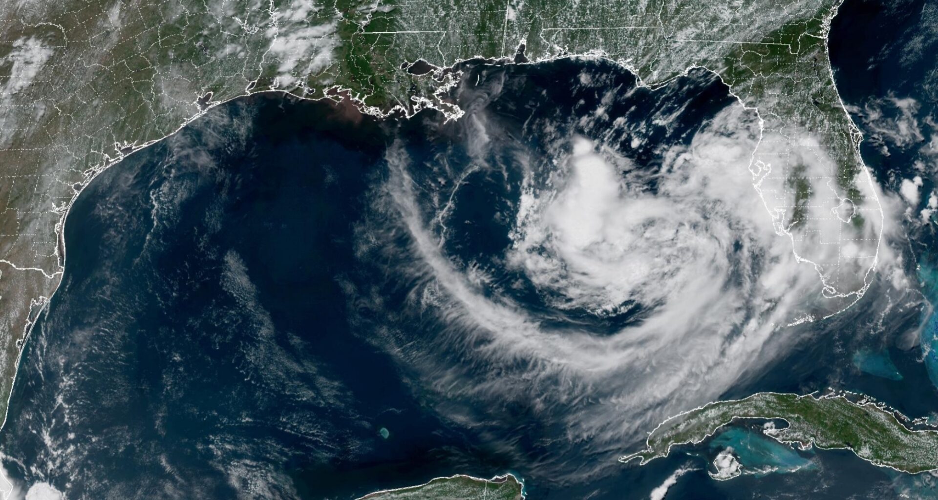
A disturbance is spinning across the eastern Gulf, as seem from satellite imagery at 1 p.m. Saturday.
NOAA
The National Hurricane Center is monitoring a low-pressure disturbance in the eastern Gulf. While the system is quite weak, forecasters are monitoring it for potential strengthening in the coming days. As it slowly drifts north-northwest over the warm Gulf waters, the disturbance has a 40% chance of becoming a tropical depression or storm.
Anytime a tropical system threatens the Gulf, some anxiety can start to build along the Texas coast. However, high-pressure developing over Texas this week is likely to “block” the Gulf system from progressing too far west. As a result, it’s unlikely to affect Houston in a major way, with the greater impacts more likely across parts of Florida, Alabama and Mississippi.
The region in the eastern Gulf has a 40% chance of developing into a tropical depression or storm.
National Hurricane Center
Even so, the Gulf disturbance will be worth monitoring over the next few days. In the meantime, high heat is expected across the Houston metro area this week. Here’s what you can expect.
Article continues below this ad
Sunday’s forecast
Houston will start Sunday with mild and muggy conditions, with temperatures hovering in the upper 70s under partly cloudy skies. By the late morning and early afternoon, skies are expected to clear out, resulting in fast-rising temperatures.
Houston temperatures are likely to reach 90 degrees by noon, with highs expected to top out near 97 degrees by the late afternoon. Humidity levels will continue to be elevated as well, leading to “feels-like” temperatures up to 104 degrees. If you have any outdoor plans, be sure to stay properly hydrated and take frequent breaks away from the sun.
Shown are the expected heat index values across Southeast Texas at 4 p.m Sunday.
Pivotal Weather
High pressure strengthens
Heading into the upcoming work week, high-atmospheric pressure is expected to move closer to the Houston area. High-pressure causes air to sink to the surface, where it compresses, warms, and forces temperatures higher.
Article continues below this ad
On Monday, high temperatures for much of the Houston metro area will top out in the upper 90s, and a few isolated locations could even touch 100 degrees. Heat index values will also stay very high, likely hovering near 105 degrees. Winds will be weak, only blowing in at 5-10 mph.
Very similar conditions are expected from Tuesday through Friday, as high temperatures are expected to top out in the upper 90s each day, with isolated triple digit temperatures also possible. Low temperatures will also stay consistent, only falling to the upper 70s to near 80 degrees each morning.
An isolated shower or weak storm can’t be completely ruled out, especially as the weak Gulf disturbance approaches the central Gulf Coast. However, overall rain chances in Houston are likely to be at just 10% or less.
Article continues below this ad
Many other parts of Texas will see even hotter weather. This includes the Dallas-Fort Worth Area, which is likely to see high temperatures between 101 and 104 degrees every day this week. Areas along the Rio Grande, from Eagle Pass to Laredo and the Rio Grande Valley, will also experience similar triple-digit heat.
Long-range weather models suggest this hot and dry pattern is likely to continue through next weekend and into the following week. The Climate Prediction Center’s outlook for July 25-31 highlights a strong likelihood of above-average temperatures across Southeast Texas, with an increased chance of triple-digit highs also developing.