
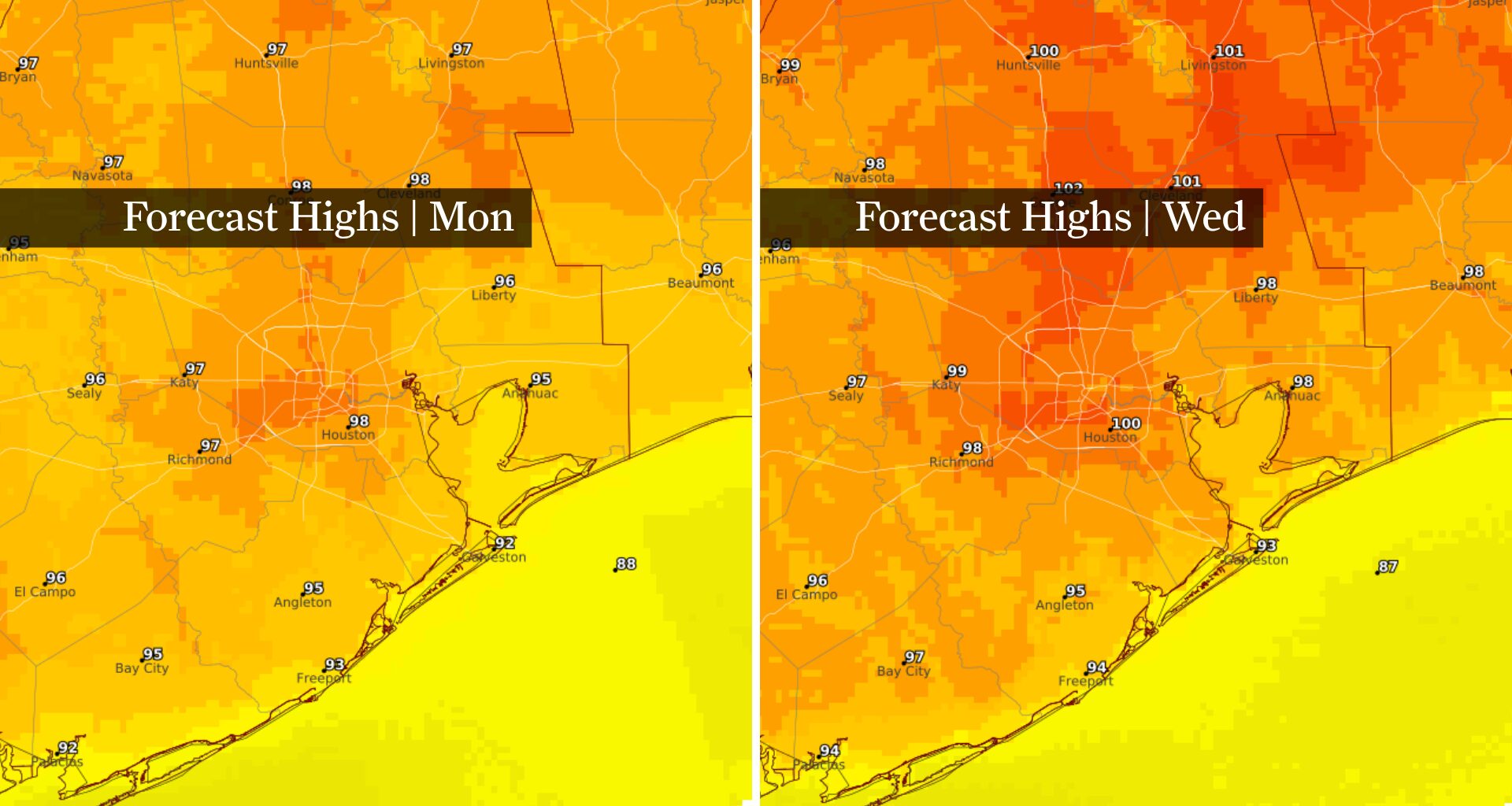
This image shows forecast highs Monday, at left, and forecast highs by Wednesday, at right. By the middle of this week, Houston will likely record its first 100-degree day of the year.
NOAA’s National Weather Service
Houston’s hottest week of the year is about to begin, with the city expected to make its strongest run yet at the elusive 100-degree mark.
A strengthening dome of high pressure will park over Texas this week, bringing several consecutive days of upper 90s, abundant sunshine and little chance for cooling rain. Humidity will stay somewhat lower through Tuesday before rising by midweek, making it feel considerably hotter.
The result is Houston’s hottest stretch of weather so far this summer — and the best opportunity yet to record its first 100-degree day of the year.
Article continues below this ad
Will Houston hit 100 degrees this week?
Houston’s best chance to reach 100 degrees for the first time this year comes Wednesday or Thursday. Many inland communities could reach the century mark even if Bush Intercontinental Airport falls just short.
DISPELLING MYTHS: Separating fact from fiction about the weather phenomenon known as El Niño.
If Houston reaches 100 degrees, it would arrive close to the city’s average first triple-digit day of the year, July 19. But that date offers little insight into how the rest of the summer unfolds. Houston’s record-breaking 2011 summer reached 100 degrees on June 2 before producing 46 triple-digit days, while 2025 didn’t hit the century mark until July 22 and still finished with eight.
Article continues below this ad
The bigger takeaway is that Houston’s hottest stretch of the summer is likely still ahead.
Heat index to climb later this week
The first half of the week won’t feature Houston’s usual combination of extreme heat and oppressive humidity. Each afternoon through Tuesday, the atmosphere will mix in drier air from aloft, lowering dew points and limiting how high the heat index climbs.
That changes by Wednesday as moisture returns.
Increasing moisture will push humidity higher through the end of the workweek. Even if actual temperatures don’t rise much beyond the upper 90s, the added moisture will send heat index values well above 100 degrees. Some locations could approach Heat Advisory criteria depending on exactly how much humidity returns.
Article continues below this ad
Will Houston’s rain chances increase later this week?
Yes, but it depends on the track of a developing tropical system in the Gulf of Mexico.
Tropical Depression Two was visible on satellite as it churned off the Florida Gulf Coast late Sunday morning. The system is expected to bring heavy rain, gusty winds, and rough surf to the central and eastern Gulf Coast early in the week.
National Oceanic and Atmospheric Administration
Most forecast guidance keeps the deepest tropical moisture and any organized low pressure offshore or closer to the middle Texas coast through the second half of the week. If that forecast holds, Houston would stay largely dry despite increasing humidity, with only isolated showers possible.
The biggest uncertainty is how far north the system’s moisture spreads. Small changes in its track could make a meaningful difference in Southeast Texas’ forecast by late week.
Article continues below this ad
TROPICAL UPDATE: Tropical Depression Two forms in Gulf, putting Texas in forecast later this week.
A farther offshore track would likely leave Houston with little more than higher humidity and oppressive heat. A track closer to the Texas coast, however, could bring increased cloud cover, higher rain chances and somewhat cooler afternoon temperatures late in the week.
At this point, the most likely outcome is still a predominantly hot and mostly dry forecast through Friday. Confidence decreases later in the week, however, as small changes in the Gulf system’s track could alter rain chances across Southeast Texas.