
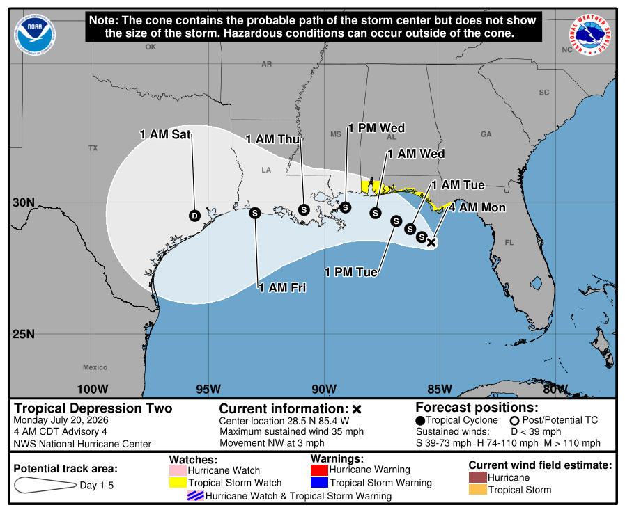
Tropical Depression Two, which formed Sunday in the northern Gulf of Mexico, could become Tropical Storm Bertha, the second named storm of the Atlantic hurricane season, while off the coast of the Florida Panhandle on Monday.
Although the Atlantic hurricane season has been underway for nearly two months, it has been relatively quiet across the tropics, thanks to a switch over from La Niña to El Niño, and the multiple Saharan dust plumes that have moved across the Atlantic.
So far, only one named storm, Arthur, briefly emerged in June. Now, we have Tropical Depression Two, which has garnered special attention in the Lone Star State because the projected path puts it along the Texas coast by Friday.
As of midday Monday, Tropical Depression Two is about 120 miles south of Panama City in the Florida Panhandle. The system is packing sustained winds of up to 35 mph and moving slowly to the northwest at 3 mph.
“On the forecast track, the depression will move near or along the northern Gulf coast during the next several days,” meteorologists at the National Hurricane Center reported in their Monday morning update. “Satellite imagery and coastal Doppler radar data indicate that the depression is getting better organized and will become a tropical storm later today. After that, additional gradual strengthening is expected through Tuesday.”
This includes a storm surge watch from the Alabama-Florida border to the mouth of the Mississippi River in Louisiana. The combination of storm surge and high tide will cause normally dry areas near the immediate coast to be flooded by rising waters from the shoreline.
Storm surge projections include:
Tropical storm conditions are likely beginning Monday night and into Tuesday with raifall totals between 2 and 4 inches, but isolated amounts could reach 8 inches. A tropical storm watch is in effect for the coasts of Mississippi and Louisiana through midweek.
We are still several days away from any potential effects in Texas, but the developing tropical system is expected to move into the western Gulf by Wednesday. The latest Global Forecast System model currently brings the system ashore along the Texas coast on Thursday before pushing farther inland on Friday.
At this time, forecast rainfall totals along the Texas coast range from a half-inch to an inch, with wind gusts of 30 to 40 mph possible. However, this forecast remains highly uncertain, as the system has not yet developed into a named tropical storm. The track, timing, and intensity are all likely to change over the coming days.
“There is much uncertainty with the track and intensity of this system and the impact that it will have on our region,” meteorologists with the National Weather Service wrote in their daily forecast discussion for Central Texas. “Being that we are not far removed from recent flooding across the area, we will continue to monitor this situation closely.”