
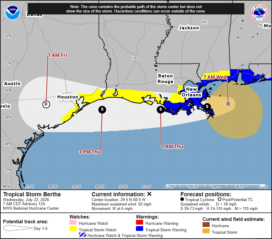
Bertha has prompted tropical storm watches to be raised along the upper Texas Gulf Coast. This does not include Houston, coastal Harris or inland Galveston counties.
NOAA’s National Hurricane Center
Tropical Storm Bertha is expected to reach Southeast Texas by Thursday afternoon. As of Wednesday morning, tropical storm watches extend as far from Bertha’s center as Sargent, along the Texas Gulf Coast.
NOAA’s National Hurricane Center
Portions of the upper Texas Gulf Coast are now under a tropical storm watch as Tropical Storm Bertha began a slow approach to its first landfall in Louisiana on Wednesday. For Houston, though, the local forecast remains largely unchanged.
As of Wednesday morning, Bertha was centered just east of the mouth of the Mississippi River with maximum sustained winds of 50 mph. It is expected to move west along the Louisiana coastline before reaching Southeast Texas late Thursday as either a tropical storm or a tropical depression.
TRACK BERTHA: Follow the path of the second named storm of the 2026 Atlantic hurricane season.
Article continues below this ad
The National Hurricane Center extended the tropical storm watch westward to Sargent, just northeast of Matagorda Bay, meaning tropical-storm conditions are possible across parts of the upper Texas coast during the next 24 to 48 hours. The watch includes portions of Galveston County but does not extend into coastal Harris County or the Houston metro area.
Tropical Storm #Bertha Advisory 12A (7 AM CDT, Wed Jul 22): Tropical Storm Watches Extended Westward Along the Extreme Southwestern Louisiana and Upper Texas Coasts. https://t.co/tW4KeGdBFb
— National Hurricane Center (@NHC_Atlantic) July 22, 2026
That doesn’t necessarily signal a worsening forecast for Houston. Tropical storm watches are issued whenever tropical storm weather is possible somewhere within the watch area. The forecast still keeps Bertha’s strongest winds, heaviest rainfall and greatest coastal hazards east of the Houston metro area.
What Bertha means for Houston
Whether Bertha crosses into Texas as a 40-mph tropical storm or a 38-mph tropical depression won’t change the forecast much across Southeast Texas. The distinction is small: Tropical storms begin at 39 mph.
Article continues below this ad
Tropical downpours could begin as early as Wednesday evening across Southeast Texas, as shown by this snapshot from future weather radar modeling for 7 p.m.
Pivotal Weather
Rainfall totals are expected to average around a half-inch or less across much of the region, with only isolated locations picking up more than an inch. That should keep the flood threat limited to localized street flooding where heavier tropical downpours briefly develop.
Winds will become occasionally breezy Thursday into Friday, but widespread tropical-storm-force winds are not expected. Current forecasts show less than a 10% chance of tropical-storm-force winds across the Houston area, increasing to 10% to 20% over the Gulf of Mexico.
Tropical-storm-force wind gusts are possible Thursday in areas under a tropical storm watch. Wind gusts could reach above 40 mph at times.
Pivotal Weather
While coastal flooding is not expected, swells generated by Bertha may create rough surf and an elevated risk of rip currents along Gulf-facing beaches through the end of the week.
Article continues below this ad
Why Bertha is weakening before reaching Texas
Bertha has become noticeably less organized since Tuesday as several factors continue working against the storm.
Persistent wind shear has repeatedly pushed thunderstorms away from the storm’s center, leaving much of the low-level circulation exposed. Without persistent thunderstorms wrapped around the center, tropical storms struggle to maintain their strength.
MAKING THE CONNECTION: What would a stronger El Niño mean for Texas hurricane season or the chances of a Houston snowfall?
Dry air has also continued wrapping into Bertha’s circulation, disrupting thunderstorm development and preventing the storm from rebuilding a more organized core.
Article continues below this ad
Bertha is also expected to spend less time over the open Gulf as it moves near or along the Louisiana coastline before reaching Southeast Texas. That limits its access to the warm water that fuels tropical systems and should allow gradual weakening to continue.
Why this week’s storm still matters
Although Bertha is expected to produce only minor hazards in Southeast Texas, it arrives just weeks before the climatological peak of Atlantic hurricane season.
Activity typically ramps up through August before peaking around Sept. 10 and remaining elevated into mid-October. That makes this week’s storm a timely reminder to review hurricane plans, restock emergency supplies and make preparations while the forecast still allows plenty of time to do so.
Article continues below this ad
For now, though, the overall forecast remains consistent: Bertha may arrive as either a tropical storm or a tropical depression, but Houston is still expected to avoid its most significant weather threats.