
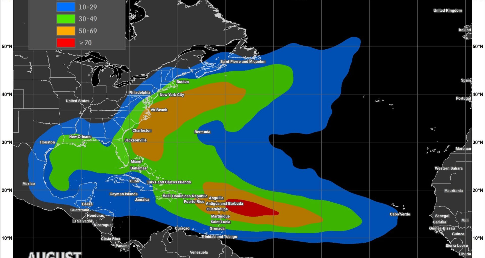
This weather satellite photo shows the Atlantic basin from the Gulf of Mexico to the west coast of Africa. As August progresses, tropical development typically expands across much of this region, marking the start of the busiest stretch of Atlantic hurricane season.
National Oceanic and Atmospheric Administration
Texas is entering the part of hurricane season that matters most.
Tropical Storm Arthur formed near the Texas coast in June. Tropical Storm Bertha followed in late July, making landfall near the Texas-Louisiana border almost exactly when the Atlantic typically produces its second named storm.
Now, as August begins, Texas enters the two months when hurricanes have historically been most likely to strike its coastline. August and September have produced more hurricanes — including most major hurricanes — than any other time of year. The reason isn’t simply that more storms form. It’s that the Atlantic itself becomes a much larger breeding ground for tropical development.
Article continues below this ad
Why August changes hurricane season
Hurricane season doesn’t suddenly become more active when the calendar flips to Aug. 1.
Instead, it gradually expands across the Atlantic basin throughout the month.
MYTH-BUSTING El NIÑO: Separating fact from fiction about the weather phenomenon known as El Niño.
Article continues below this ad
Early August still favors tropical development relatively close to the United States, including the Gulf of Mexico, western Caribbean and waters near the Bahamas. Those storms often provide Gulf Coast communities with relatively little warning before reaching land.
As the month progresses, the focus shifts eastward.
Ocean waters continue warming after months of summer sunshine, tropical waves of low air pressure rolling off Africa become more frequent, and atmospheric conditions become increasingly favorable across the Main Development Region — a broad swath of the tropical Atlantic stretching from the west coast of Africa to the Caribbean.
Tropical activity in the Atlantic basin begins to climb in mid-August before peaking in early September. Texas faces its highest risk of a tropical storm or hurricane making landfall during a two-month stretch starting in August and lasting through September.
National Hurricane Center
Many of the Atlantic’s strongest and longest-lived hurricanes begin in the Main Development Region before crossing thousands of miles of warm ocean. Storms that form there often spend days crossing warm ocean waters, giving them more time to organize and strengthen. Hurricane Beryl in 2024, for example, developed there before becoming the earliest-forming Category 5 hurricane ever recorded in the Atlantic.
Article continues below this ad
MORE ON BERYL: Beryl roared into upper Texas Gulf Coast 3 mph shy of being Category 2, report found.
By late August, nearly every traditional breeding ground is active, from the Main Development Region to the Caribbean, Gulf of Mexico and western Atlantic.
That’s why August marks the beginning of the Atlantic’s rapid climb toward its climatological peak around Sept. 10.
Why August and September matter for Texas
History explains why Texas should pay especially close attention once August arrives.
Article continues below this ad
Since 1851, more hurricanes have affected Texas during August and September than during any other two-month period of hurricane season. Most of the state’s major hurricane landfalls have also occurred during those months, when Gulf waters are at their warmest and tropical activity across the Atlantic reaches its annual peak.
Many of the storms that have shaped modern Texas history also arrived during this same stretch of the calendar.
August marks the beginning of peak activity in the Atlantic hurricane season. This NOAA map of the Atlantic basin shows where named tropical storms have historically occurred during the month, highlighting the Main Development Region east of the Caribbean, where many of the basin’s strongest hurricanes first develop.
National Oceanic and Atmospheric Administration
September is the climatological peak of Atlantic hurricane season. This NOAA map shows where named tropical storms have historically been most common during the month, with the highest concentrations stretching from the Main Development Region east of the Caribbean into the western Atlantic.
National Oceanic and Atmospheric Administration
Hurricane Harvey made landfall near Rockport on Aug. 25, 2017, before stalling over Southeast Texas and producing catastrophic flooding across the Houston region. Hurricane Ike came ashore near Galveston on Sept. 13, 2008, driving a devastating storm surge across the upper Texas Coast and leaving millions without power.
The storms differed dramatically in size, strength and damage, but both struck during the climatological heart of hurricane season.
Article continues below this ad
Can Texas still get hurricanes during El Niño?
Yes — although history suggests they’re less common.
El Niño strengthens upper-level winds across much of the tropical Atlantic, increasing vertical wind shear that can disrupt developing tropical systems before they organize and intensify. Texans have already seen that process this year. Earlier this season, both Tropical Storm Arthur and Tropical Storm Bertha battled persistent wind shear that prevented either system from strengthening into a hurricane before making landfall.
Even so, tropical storms continue to reach Texas during El Niño years.
From left, historical August tropical cyclone tracks since 1850 are compared with those during El Niño years since 1950. El Niño typically reduces Atlantic hurricane activity by increasing disruptive wind shear, resulting in fewer storms affecting the Gulf Coast. Even so, tropical cyclones continue to reach Texas during El Niño years.
NOAA’s National Hurricane Center
Since reliable El Niño records began around 1950, 11 tropical storms have affected the Texas Gulf Coast during El Niño years, but only one hurricane has approached the state. Hurricane Audrey made landfall just east of Port Arthur in southwest Louisiana in June 1957 as a strong Category 3 hurricane, driving destructive storm surge across portions of the upper Texas Coast.
PACIFIC STRENGTHENING: Hurricane Genevieve exploded into a major storm. Here’s why Texans should care.
One of this season’s more unusual footnotes involves the name Bertha. This isn’t the first time a storm named Bertha has affected Texas during an El Niño year. Bertha also reached Texas in 2002 and 1957. Each shared a connection with the 2026 storm. The 2002 Bertha first made landfall in southeast Louisiana before making a second landfall in South Texas, while the 1957 Bertha came ashore near the Texas-Louisiana border.
Seasonal outlooks describe activity across the Atlantic basin — not whether any one stretch of coastline will be affected. It only takes one storm to define a hurricane season.
What Texans should do now
The arrival of August doesn’t mean a hurricane is about to threaten Texas.
It does mean the odds of tropical development will increase over the coming weeks, making now a good time to review evacuation plans, restock emergency supplies and check flood insurance coverage before a storm appears on the forecast map. Most National Flood Insurance Program policies require a 30-day waiting period before new coverage takes effect.
For Texas, the busiest part of hurricane season is only just beginning.