
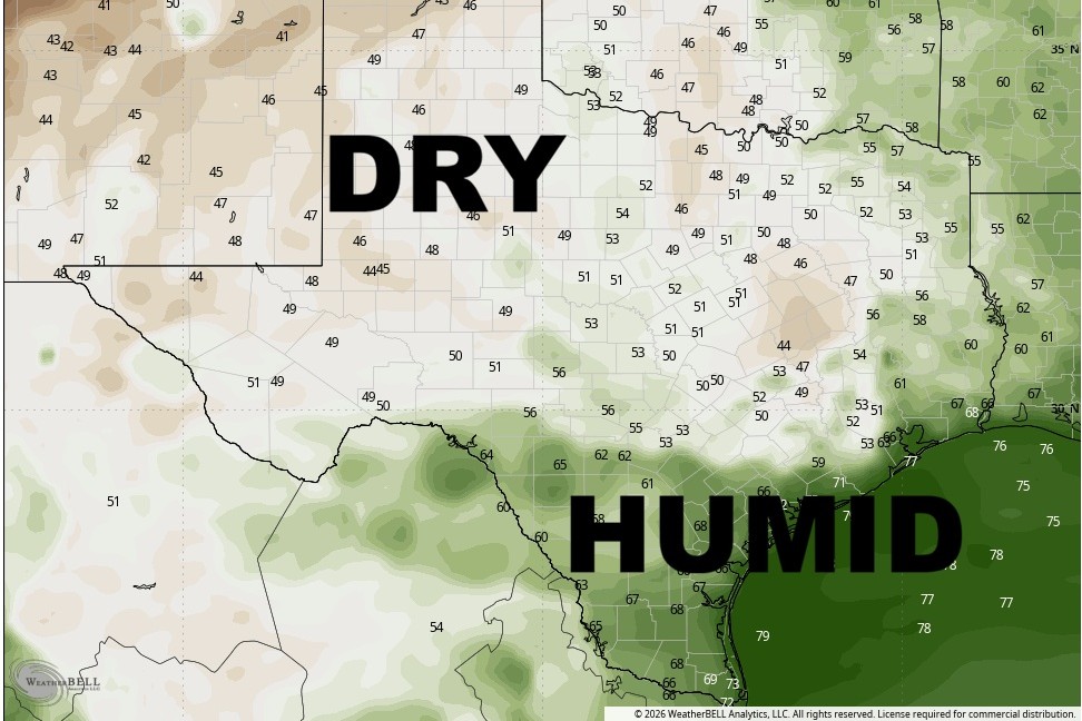
Are we sure it’s the second day of August? It certainly won’t feel like it, thanks to the rare summer cold front that moved through Central Texas on Saturday. The biggest difference Sunday will be the humidity — or lack of it.
Some lingering clouds will stick around Sunday morning, with temperatures in the middle to upper 70s. Skies will then give way to sunshine by mid-morning with light northerly winds.
Afternoon temperatures will climb back into the 90s, but it will feel noticeably different, thanks to much lower humidity. Dew point temperatures, which tend to rise with the level of moisture in the air, will fall into the lower 60s, compared to the lower 70s we experienced much of last week.
Dew point, or the temperature at which dew forms, correlates with the amount of moisture in the air, and readings around 60 degrees or less are generally considered comfortable. Once dew points climb above 65 degrees, conditions begin to feel uncomfortable, while readings above 70 degrees can feel downright oppressive. So, yes, this drier air will be a very welcome change.
The subtropical ridge of high pressure will move eastward and extend back over Texas, favoring a dry and hot weather pattern through Friday. The southerly wind flow will establish itself back across the region by Monday afternoon leading to an uptick in humidity and heat index values by midweek.
Looking back at July, we already recorded five days of triple-digit heat, with the hottest temperature reaching 103 degrees on July 22. On the flip side, there were two days when temperatures failed to reach the 80-degree mark, and those cooler days coincided with the bulk of the month’s 4.24 inches of rain during a four-day stretch of heavy rainfall in the week of July 11.
Overall, July will go down as the 39th-warmest July on record and the 17th-wettest, based on observations dating back to the late 1890s. With temperatures running above average for much of the month, the heat was certainly noticeable but the rain helped provide a few breaks from the summer heat.
We’re heading into the final week or so of the official “dog days of summer,” a phrase often used to describe the hottest days of the year. But did you know the dog days actually refer to a specific period from July 3 through Aug. 11 each year?
For Austin, this stretch also lines up with the hottest temperature of the year, with the average high reaching 99 degrees and staying there through Aug. 14 before dropping back to 98 degrees a day later and then down to 95 degrees by Aug. 31.
Looking at rainfall records, Austin receives about 2.74 inches, on average, during August. Despite the rain on the first day of the month, however, the next week or so is expected to be mostly dry across the Lone Star State, according to the Climate Prediction Center’s outlooks for the next six to 10 days and the next eight to 14 days.
Overall, for the month, the outlook is warmer than normal and drier than normal.