
Humidity-driven heat index values will be in the triple digits by 3 p.m. Saturday in San Antonio, according to the National Blend of Models, a composite weather forecast model.
National Blend of Models/Pivotal Weather
San Antonio is kicking off August on Saturday with more of the same hot and dry weather but, thanks to a rare summer cold front surging into Texas, rain could be a welcome surprise overnight, according to the National Weather Service.

Saturday is shaping up to have a 20% chance of rain after 4 p.m., forecasters said, with daytime temperatures in San Antonio peaking at 99 degrees. Humidity, though, will make that projected high temperature feel more like 108 degrees.
Article continues below this ad
At night, San Antonio’s rain chances will hold steady at a slight 20% amid increasing cloudiness and overnight temperatures that will stay above 79 degrees into Sunday morning.
A subtropical ridge of high atmospheric pressure has been driving our recent stretch of hot and rain-free days, but its grip on Texas weather is loosening this weekend, forecasters said.
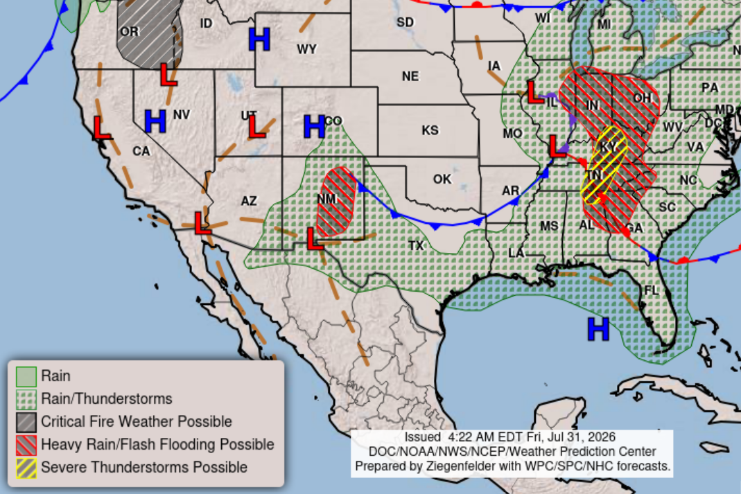
Heat index values in Texas would be elevated Saturday as higher levels of atmospheric moisture along a rare August cold front intersected with the warmer temperatures across the state.
Weather Prediction Center/National Weather Service
“As the ridge moves a little more west, the (air) flow aloft will turn more northerly,” the weather service said in a forecast bulletin Friday. “This will allow a weak front to approach South-Central Texas on Saturday.”
Article continues below this ad
Forecasters said heat index values would be elevated Saturday as the higher levels of moisture along the front intersected with the warmer temperatures in Texas.
“Most models bring the weak front over the area Saturday afternoon,” the weather service said. “A low to medium chance (20% to 40%) of rain accompanies the front, mainly in the form of isolated to scattered showers and thunderstorms.”
While rain chances will be higher farther north of San Antonio, “the best chances for rain are favored Saturday afternoon and evening, subject to when the front arrives,” forecasters said, adding that “rain chances linger through Saturday night, by which time the front should be exiting our area to the south.”
Article continues below this ad
Don’t count on any substantial rainfall, though, as projected rainfall amounts are likely to be limited by “the narrow stretch of favorable conditions” and will be “mostly ranging from a few hundredths to a quarter inch.”
Summertime heat resumes in San Antonio on Sunday, seemingly without skipping a beat. Look for mostly sunny skies Sunday and afternoon temperatures hitting 100 degrees. However, the air will feel noticeably drier as north-northwest winds shift to become east-northeast, forecasters said.
“After Saturday’s front passes, notably drier continental air will spread across South-Central Texas,” the weather service said. “While temperatures are not expected to change much in the wake of the front, the decrease in moisture Sunday and potentially Monday will help provide a temporarily drier heat.”
Article continues below this ad
In this weather satellite photo of Texas taken around 1:30 p.m. Friday, skies were largely cloud-free and are likely to remain that way on Saturday before a rare August cold front surges into the state.
Geostationary Operational Environmental Satellites/CIRA and NOAA
By Sunday night, those northeast winds shift again to become south-southwest after midnight, forecasters said.
San Antonio on Monday will again be sunny and hot, with temperatures also soaring to 100 degrees again as the subtropical ridge of high air pressure returns to our region of the country. This time, south-southeast winds of around 5 mph in the afternoon will start delivering moisture-rich air as the ridge restores southerly air flow.
Article continues below this ad
“By about midweek, peak afternoon heat indices may once again exceed 105 (degrees) for the I-35 corridor and low-lying plains,” the weather service said. “Continue to practice heat safety and stay cool and hydrated.”