
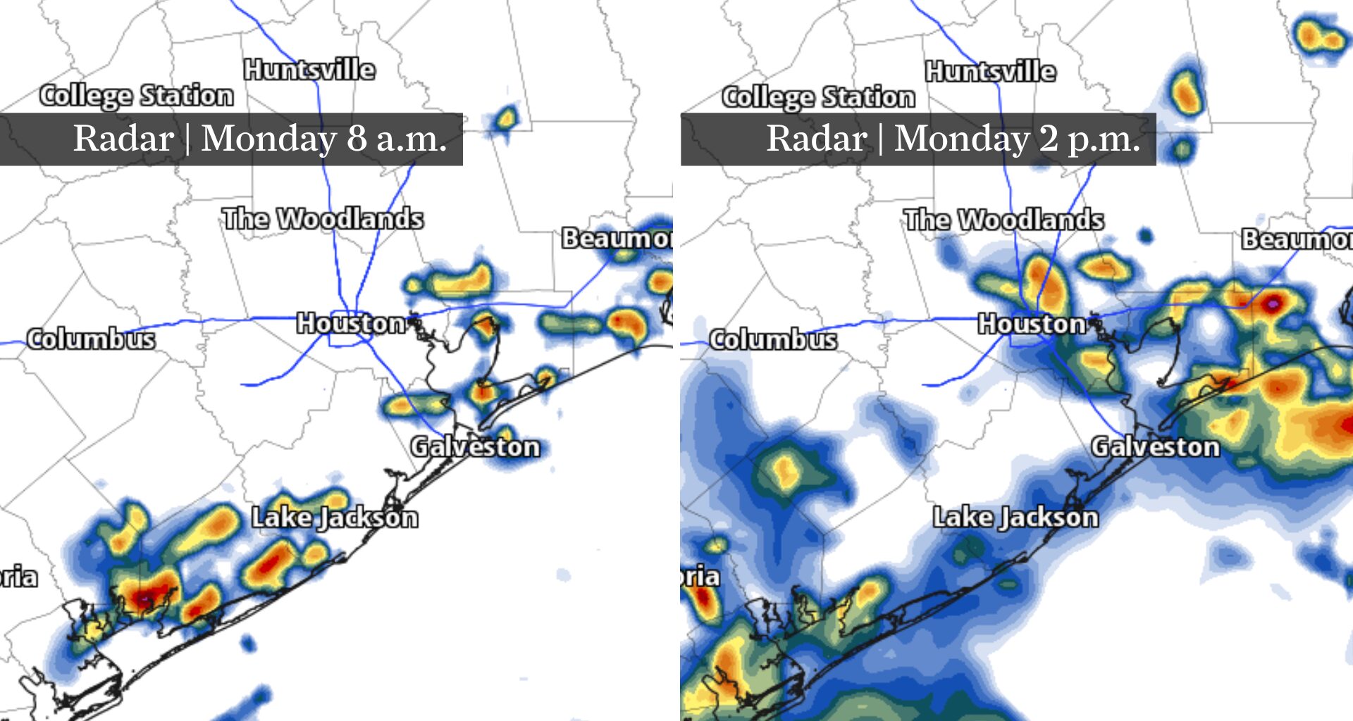
This image shows how radar could look Monday at 8 a.m., at left, and 2 p.m., at right. Storms south of Houston in the morning could reach HISD students on their first day in the classroom by the early afternoon.
Pivotal Weather
Houston students are heading back to class Monday — and thunderstorms could complicate the first-day routine.
Scattered showers and thunderstorms are expected to develop as deep tropical moisture hangs over Southeast Texas. Most storms should arrive during the daytime, making the afternoon trip home more likely to encounter heavy rain, lightning or gusty winds than the morning commute.
For Houston ISD students returning to the classroom, timing will matter. Here’s how Monday’s weather could unfold from the first bus stop to afternoon dismissal.
Article continues below this ad
Houston’s back-to-school weather timeline for Monday
Bus stop: Monday morning should start relatively quiet in Houston, although patchy fog could develop in spots. Scattered downpours are most likely during the morning hours along the coast. Otherwise, expect a warm and muggy start with temperatures quickly rising after sunrise. Most thunderstorms should hold off during the morning, giving students a better chance of staying dry on the way to school.
Lunch and recess: Rain chances will begin increasing as temperatures climb through the 80s and the sea breeze pushes inland. Scattered showers and thunderstorms could develop by late morning and around lunchtime, especially as tropical moisture fuels heavier downpours. Outdoor recess could become a game-time decision at some schools.
HOUSTON WEATHER: Sign up for texts to get forecasts and extreme weather alerts on your phone.
Article continues below this ad
Afternoon pickup: This is the part of the school day to watch most closely. Scattered thunderstorms could be roaming the Houston area around dismissal, producing frequent lightning, gusty winds and locally heavy rain. Storms will be slow-moving and somewhat disorganized, so conditions could vary dramatically from one campus to another.
Students walking home, waiting at bus stops or heading to after-school activities should be prepared for rapidly changing weather. A school could get soaked while another several miles away stays completely dry.
Neighborhoods that miss the rain will face another problem: heat. Temperatures will climb into the mid-90s in most locations, with humidity pushing heat index values into the triple digits.
Houston rain chances fade Tuesday
Monday’s scattered thunderstorms won’t signal the beginning of a wetter pattern.
Article continues below this ad
Rain chances taper off Tuesday as high pressure builds over the northwestern Gulf of Mexico, making it harder for showers and thunderstorms to develop.
At the same time, temperatures will begin climbing again. Houston should trend hotter through the end of the workweek as the influence of high pressure strengthens.
That means Monday’s back-to-school storms may offer temporary relief from the August heat, but Houston’s more familiar hot and increasingly dry summer weather won’t be far behind.
Tropical Atlantic becomes more active this week
Far beyond Houston, the tropical Atlantic is showing more activity as the heart of hurricane season approaches.
Article continues below this ad
Multiple tropical waves are moving across or emerging into the Atlantic, with at least some potential for gradual development this week. One disturbance over the central tropical Atlantic has a relatively low chance of developing as it moves generally westward, with conditions expected to become less favorable later in the week.
Another tropical wave moving off Africa bears watching more closely. Conditions could support gradual organization as it travels westward across the eastern and central tropical Atlantic, with the potential for a tropical depression to develop later this week.
HURRICANE ODDS: Texas hurricane odds have changed dramatically since April. Here’s why.
Article continues below this ad
Neither system poses an immediate threat to Houston or the Gulf Coast. Both remain thousands of miles away, and there is plenty of time for their strength, organization and eventual tracks to change.
Still, this activity is a reminder that August marks the beginning of the climatologically busiest stretch of the Atlantic hurricane season. Any disturbance crossing the tropical Atlantic is worth monitoring for changes in the days ahead.