
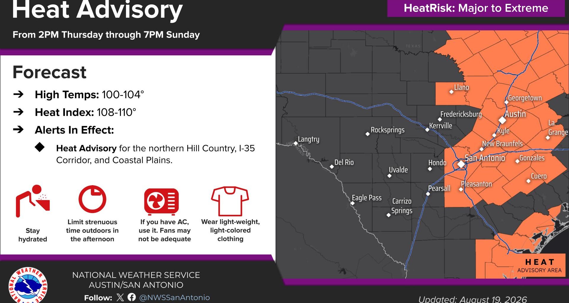
A heat advisory has been issued across parts of South-Central Texas, including San Antonio, from Thursday through Sunday.
NWS Austin/San Antonio
The past week in South Texas has been the region’s hottest week of the year, and the heat is not letting up anytime soon.

In fact, temperatures and humidity values are about to rise to even higher levels on Thursday, which has prompted the National Weather Service to issue a heat advisory for much of the region.
Article continues below this ad
The advisory will go into effect at 2 p.m. Thursday afternoon, and it will stay active through Friday and the weekend as temperatures will climb into the triple digits each day. The entire San Antonio metro area is included in the advisory, along with much of the Interstate 35 corridor, including New Braunfels, San Marcos and Austin.
Additionally, areas south and east of San Antonio are also a part of the advisory, including Pleasanton, La Vernia, Floresville, Seguin, Gonzales and Cuero.
Shown are the potential heat index values across the region at 4 p.m. Thursday afternoon
Pivotal Weather
According to the National Weather Service, some spots within the heat advisory could encounter heat index values up to 110 degrees. But exactly how hot will temps climb in San Antonio? Here’s the updated forecast.
Article continues below this ad
Thursday’s forecast
Before the heat really takes hold, Thursday morning will be relatively pleasant, as temperatures will sit in the upper 70s through 8:30 a.m. Partly cloudy skies are anticipated early, but as more sunshine prevails by the middle of the day, temperatures will rise quickly.
San Antonio will reach 90 degrees just after 11 a.m., continuing to rise to the 100-degree mark just after 2 p.m. Afternoon high temperatures are likely to be near 102 degrees by 4 p.m., which would be tied for the hottest temperature recorded so far this year. Mostly sunny skies are expected, and there is no chance of rainfall.
Humidity levels will be higher than they were on Wednesday, resulting in a heat index of up to 108 degrees. Values this high can lead to heat exhaustion or heat stroke in as little as 20 minutes. If you have to be outside, be sure to drink plenty of water, wear light and loose-fitting clothing, and take frequent breaks in air-conditioned spaces.
Article continues below this ad
Limit strenuous activity to the early morning or late in the evening. Avoid the middle of the day, especially between 11 a.m. and 8 p.m.
High heat continuing
Very similar heat is expected across the region on Friday, as high atmospheric pressure continues to dominate the weather pattern over South-Central Texas. High temperatures will rise to around 102 again, with heat index values up to 108 degrees.
A few isolated showers and storms are possible across parts of North and East Texas, but overall rain chances will stay less than 20% in areas like Dallas and Houston. San Antonio’s rain chances will be even lower, with less than a 10% chance of rainfall.
Article continues below this ad
No significant changes are expected over the weekend, but as high pressure becomes positioned more directly over the region, temperatures may even rise slightly higher. San Antonio will likely reach highs near 103 degrees both Saturday and Sunday, with heat index values up to 109 degrees.
High heat and humidity will continue throughout much of next week as well. While highs may drop by a degree or two, triple-digit temperatures are still likely nearly every day through the end of August. Little to no rainfall is also expected throughout the region until at least the first week of September.