
Houston’s stubborn August heat is about to turn up another notch, with a heat advisory taking effect at noon Thursday as dangerously high feels-like temperatures build across Southeast Texas.
The advisory continues through 7 p.m. Friday, when heat index values could reach 106 to 110 degrees during the afternoon. Highs will top out around 99 to 102 degrees across inland areas, with lower 90s along the coast. There won’t be much relief after sunset either, with overnight lows only falling into the upper 70s and 80s.
Thursday and Friday afternoons will bring the toughest stretch of heat this week as increasing moisture makes it harder for the body to cool itself. The most uncomfortable part of the day will likely come from the afternoon into the early evening, when temperatures are near their peak.
If you have to spend time outside, plan for frequent breaks, plenty of water and as much shade or air conditioning as you can find. Moving strenuous work or exercise to the morning will help, though temperatures will already be climbing quickly after sunrise.
The heat advisory could be extended into the weekend if this pattern hangs on.
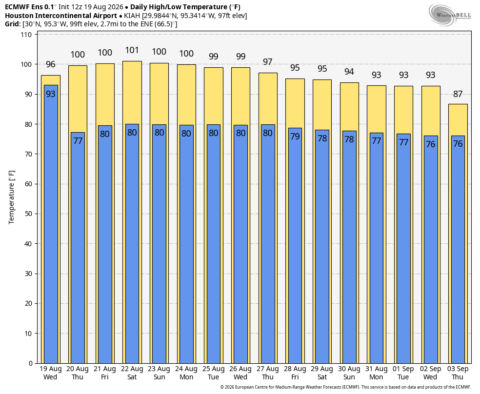
Houston’s stretch of 100-degree heat looks likely to continue through the weekend, but exactly when it ends becomes less clear after that.
Both the European and American ensemble models keep afternoon highs near or above 100 through at least Monday. From there, they begin to split. The European ensemble gradually lowers highs into the upper 90s by Tuesday and Wednesday and hints at a more noticeable break from the heat late next week. The American ensemble holds onto temperatures near 100 for longer.
Ensemble models run the forecast many times with slightly different starting conditions, giving us a better sense of the range of possible outcomes and how confident we can be in the broader trend.
The deterministic models show an even wider range. A deterministic model is one individual forecast run that produces a single outcome. The European model shows temperatures falling more sharply late next week, while the American model keeps the heat much more entrenched and even brings highs above 105 degrees again.
That kind of spread is a good reason not to get too attached to any one temperature that far out. The safer takeaway is that triple-digit heat should stick around through the weekend and probably into early next week, with any meaningful break still uncertain.
Rain won’t offer much help either. Most of Southeast Texas should stay dry, with only a slim chance for a brief shower or storm, mainly northeast of Houston.