
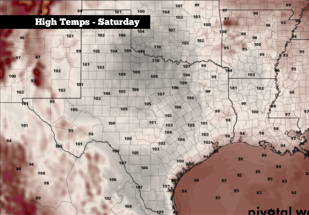
Shown are the potential high temperatures across the state on Saturday. Highs could rise near 110 degrees for parts of North and Northwest Texas.
Pivotal Weather
A very strong high pressure system, which had been centered over New Mexico over the past few days, has been responsible for the consistent triple-digit heat across Texas. However, the center of the high is now set to shift eastward over parts of Northwest Texas this weekend, causing temperatures to rise even higher.

For parts of the state, highs could rise to between 106 to 110 degrees from Friday and into the weekend. Temperatures won’t be quite that hot in South Texas, but highs will still challenge record levels in the Alamo City. Here’s a breakdown of what you can expect.
Article continues below this ad
Friday’s forecast
A warm and very muggy morning is anticipated across South Texas on Friday, as temperatures are expected to hover near 80 degrees between 5 a.m. and 9 a.m. A few clouds are likely during the morning, but skies will be mostly sunny by the late morning and early afternoon.
Temperatures will rise very quickly, reaching 90 degrees as early as 11 a.m. before hitting the 100-degree mark just after 2 p.m. Afternoon highs are likely to reach 102 degrees, which is 6 degrees above average for late August.
Shown are the expected heat index values across the region at 4 p.m. Friday.
Pivotal Weather
High humidity is expected to continue throughout the day, leading to heat index values up to 109 degrees in the Alamo City. This is a dangerous level of heat, capable of causing heat exhaustion or heat stroke. Limit time outdoors, but if you have to be out, stay hydrated, wear loose and light-fitting clothing, and take frequent breaks in air conditioned spaces.
Article continues below this ad
Even hotter weather coming
Temperatures will continue to inch higher by Saturday and Sunday as high pressure moves closer. San Antonio’s forecasted high temperature Saturday is 103 degrees, which would be the city’s hottest temperature recorded so far this year. Afternoon heat index values will once again reach between 107 and 109 degrees.
By Sunday, San Antonio could challenge the daily record high temperature of 104 degrees, which was set in 2009. Morning lows will also stay consistent, falling into the upper 70s to near 80 degrees.
A very strong high pressure system, which had been centered over New Mexico over the past few days, has been responsible for the consistent triple-digit heat across Texas. However, the center of the high is now set to shift eastward over parts of Northwest Texas this weekend, causing temperatures to rise even higher.
For parts of the state, high temperatures could rise to between 106 to 110 degrees from Friday and into the weekend. Temperatures won’t be quite that hot in South Texas, but highs will still challenge record levels in the Alamo City. Here’s a breakdown of what you can expect.
Friday’s forecast
A warm and very muggy morning is anticipated across South Texas on Friday, as temperatures are expected to hover near 80 degrees between 5 a.m. and 9 a.m. A few clouds are likely during the morning, but skies will be mostly sunny by the late morning and early afternoon.
Temperatures will rise very quickly, reaching 90 degrees as early as 11 a.m. before hitting the 100-degree mark just after 2 p.m. Afternoon highs are likely to reach 102 degrees, which is 6 degrees above average for late August.
High humidity is expected to continue throughout the day, leading to heat index values up to 109 degrees in the Alamo City. This is a dangerous level of heat, capable of causing heat exhaustion or heat stroke. Limit time outdoors, but if you have to be out, stay hydrated, wear loose and light-fitting clothing, and take frequent breaks in air conditioned spaces.
Even hotter weather coming
Temperatures will continue to inch higher by Saturday and Sunday as high pressure moves closer. San Antonio’s forecasted high temperature Saturday is 103 degrees, which would be the city’s hottest temperature recorded so far this year. Afternoon heat index values will once again reach between 107 and 109 degrees.
By Sunday, San Antonio could challenge the daily record high temperature of 104 degrees, which was set in 2009. Morning lows will stay consistent in the upper 70s to near 80 degrees.
Farther north across Texas, temperatures will be even hotter. Cities such as Wichita Falls, Childress, Sherman, and Denton could see temps nearing 110 degrees over the weekend. Across the DFW metroplex, highs could rise up to 108 degrees.
The intense heat may help to trigger a few isolated thunderstorms across parts of North and Central Texas by Saturday afternoon. However, overall coverage will stay very low, with just a 20% chance of rain from Dallas south to Waco. Rain chances from Austin to San Antonio will be lower than 10%
Any relief next week?
This current streak of triple-digit days is likely to continue into much of next week. San Antonio temperatures may decrease by a degree or two, but highs are still likely to top out at 100 to 102 degrees from Monday through Wednesday.
After that, there is some potential that temperatures could dip into he upper 90s by the end of next week. However, if high pressure continues to stall out over the state, highs could very well stay above 100 degrees.
Long-range weather models suggest that temperatures may finally decrease more meaningfully by the first or second week of September. But until then, San Antono is locked into what will go down as the hottest part of the year.
Article continues below this ad
Farther north. temperatures will be even hotter. Cities such as Wichita Falls, Childress, Sherman and Denton could see temps nearing 110 degrees over the weekend. Across the DFW metroplex, highs could rise up to 108 degrees.
The intense heat may help to trigger a few isolated thunderstorms across parts of North and Central Texas by Saturday afternoon. However, overall coverage will stay very low, with just a 20% chance of rain from Dallas to Waco. Rain chances from Austin to San Antonio will be even lower, likely with less than a 10% chance of rain.
Any relief next week?
This current streak of triple-digit days is likely to continue into much of next week. San Antonio temperatures may decrease by a degree or two, but highs are still likely to top out at 100 to 102 degrees from Monday through Wednesday.
Article continues below this ad
After that, there is some potential that temperatures could dip into the upper 90s by the end of next week. However, if high pressure continues to stall out over the state, highs could very well stay above 100 degrees.
Long-range weather models suggest temperatures may finally decrease more meaningfully by the first or second week of September. But until then, San Antonio is locked into what will likely end up being the hottest part of 2026.