
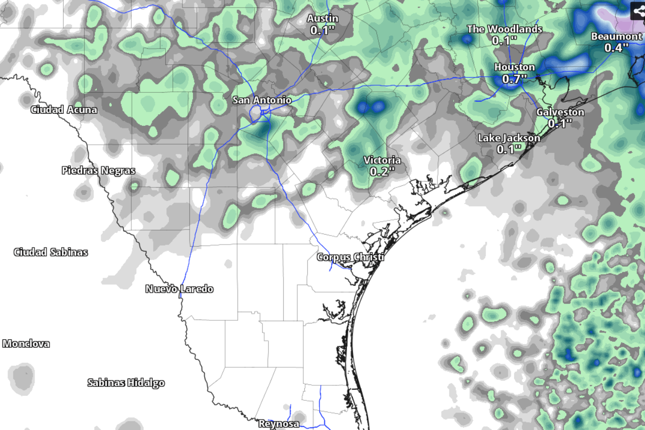
South Texas is unlikely to see much cumulative rainfall Thursday through 7 a.m. Friday, according to the National Blend of Models, a composite weather forecast model.
National Blend of Models/Pivotal Weather
After more than a month of waiting for measurable rainfall, San Antonio on Thursday will have a 40% chance of afternoon showers, according to the National Weather Service.

Otherwise, look for sunshine and plenty of hot weather as afternoon temperatures climb to 100, but likely no higher than that. Meanwhile, humidity-driven heat index values will make those afternoon temperatures feel more like 108.
Article continues below this ad
A heat advisory for parts of South-Central Texas that has been in place most of this week will remain in effect Thursday until 7 p.m., forecasters said.
What’s behind the forecast for Thursday?
If San Antonio temperatures do make it to 100 on Thursday, that would be the 11th day in a row of triple-digit heat out of 15 days for the year so far. But the rain chances Thursday and added clouds Friday could finally break the city’s heat streak, according to forecasters.
The daytime rain chance of 40% will edge lower to 30% Thursday night. Skies will turn partly cloudy, while overnight temperatures will bottom out around 78 degrees before sunrise Friday.
Article continues below this ad
The heat dome of high atmospheric pressure that’s been the dominant influence on our hot and rain-free weather in South Texas was continuing its westward shift on Thursday, allowing upper-level winds to flow in from the northwest, forecasters said.
“A few (atmospheric) disturbances may develop and move south into the area with the highest rain chances beginning Thursday afternoon as a front slowly moves towards the area,” the weather service said in a forecast bulletin posted online Wednesday.
While atmospheric moisture and daytime heating will allow for some rain showers to occur, “we are not expecting widespread rain across the area,” forecasters said. Cumulative rainfall totals through Friday likely will be only small fractions of an inch.
Article continues below this ad
“Any convection that does manage to develop will likely be high (temperature)-based and would pose a gusty wind threat in any of the stronger cells,” the weather service said in the bulletin.
What’s the forecast for Friday and beyond?
“Low to medium rain chances continue Thursday night into Friday with a boundary (of a cold front) in the area,” the weather service said. “There may be lesser coverage in any showers or thunderstorms Friday due to the slight eastward progression of the mid-level ridge during the day.”
Article continues below this ad
San Antonio on Friday should be mostly sunny and hot with afternoon temperatures reaching 99 degrees. In the evening, east-southeast winds of 5 to 10 mph will bring more moisture-rich air into the region.
Humidity-driven heat index values could reach 108 degrees in San Antonio by 3 p.m. Thursday, according to the National Blend of Models, a composite weather forecast model.
National Blend of Models/Pivotal Weather
“An increase in moisture will bump up heat index values, however, so there may be a need for additional heat products (or alerts), but confidence is low at this time.”
Saturday in San Antonio is expected to be sunny with a high near 98 degrees, which would be well above normal but at least still below 100.
Article continues below this ad
“Weak ridging (of high pressure) this weekend is interrupted by a disturbance moving towards the Gulf Coast early next week,” the weather service said. “This could bring back some low rain chances to the area and keep highs below heat advisory levels.”