
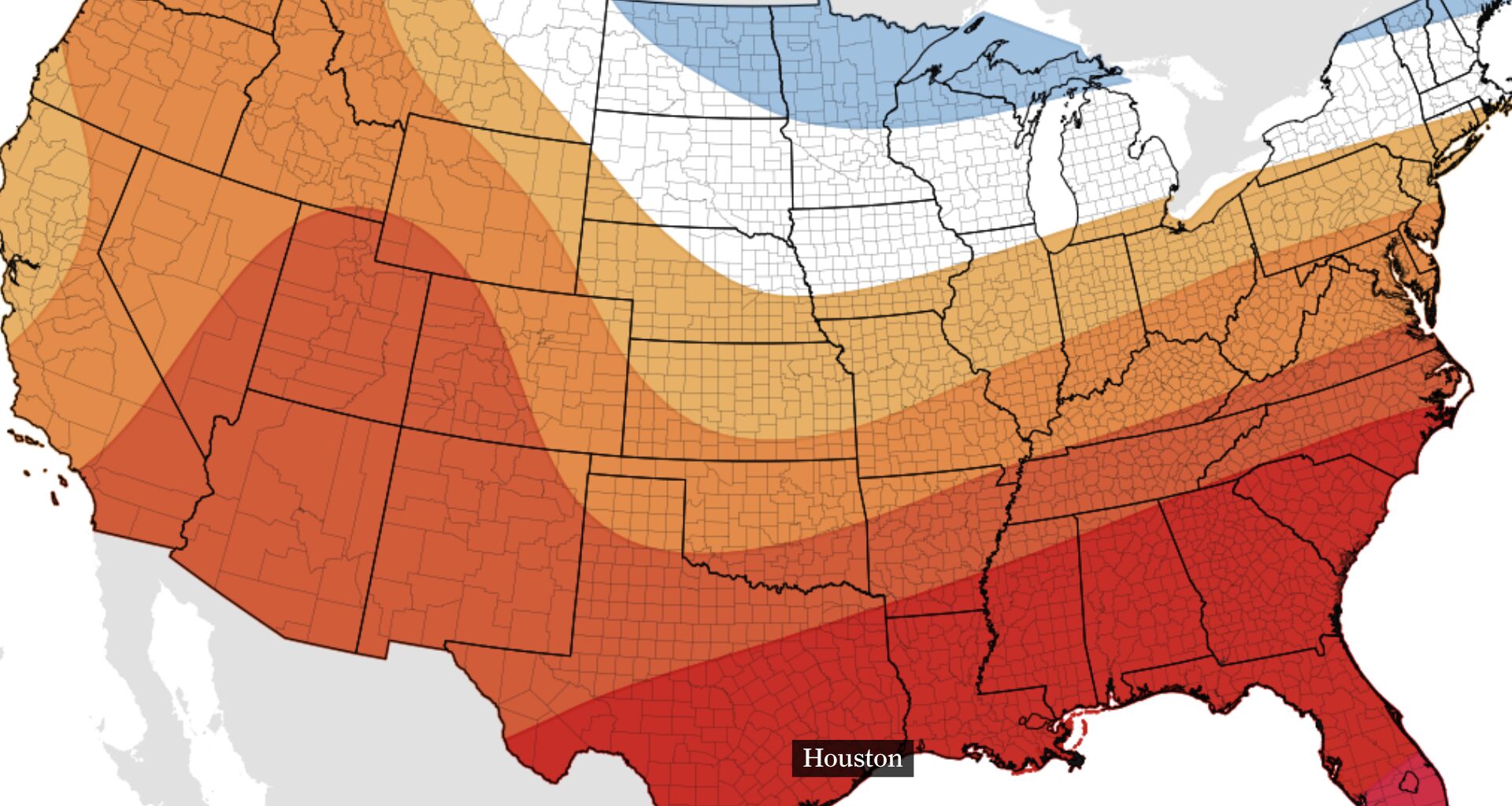
This map of the U.S. shows the temperature outlook for Aug. 17 through 23, according to NOAA’s Climate Prediction Center. Above normal temperatures are expected across much of the country, with only the northernmost areas of the Midwest and Northeast expecting below normal temperatures.
NOAA’s Climate Prediction Center / Pivotal Weather
September may mark the start of fall on the calendar, but in Houston it often feels like August’s encore, and Saturday’s forecast will keep summer going.
Saturday’s storms could provide a brief break from the heat, but the bigger question is when Houston will get a real one. Some long-range models are showing the first hints of lower temperatures after Sept. 20, while the Climate Prediction Center still favors above-normal temperatures across Texas through Sept. 23.
The forecast may be hinting at relief, but it is not ready to promise fall.
Article continues below this ad
Saturday storms could briefly ease Houston heat
Saturday should follow the same general script we’ve seen this week, with showers and thunderstorms developing by late morning along the coast before becoming more numerous as they spread inland toward Houston.
Much like earlier days this week, the best window for outdoor plans will likely be before 10 or 11 a.m. If you can’t move your plans earlier, scattered downpours are far from a guarantee that rain will fall in your backyard. A few storms could produce heavy rain, frequent lightning and gusty winds, but widespread rain is not expected.
FIRST FALL COLD FRONT: Waiting on sweater weather? Here’s when Houston usually gets its first cold front.
Article continues below this ad
The silver lining to the weekend storm chances is that clouds and rain should hold temperatures closer to average in the lower to middle 90s. The heat index could still climb above 100 degrees during the afternoon, so heat safety remains important.
Continued heat and daily storms into next week
Into early next week, showers and thunderstorms will remain possible, especially near the sea breeze. A ridge of high pressure could build over the region from the southeastern U.S., bringing somewhat drier air and more sunshine.
Daily rain chances should range from 20% to 40%, while more sunshine could push temperatures more consistently into the middle 90s.
Article continues below this ad
Long-range models hint at cooler Houston temperatures
The European model begins showing a more noticeable cooling trend around Sept. 20-21, with highs eventually falling into the upper 80s and lower 90s. The American model is slower, keeping temperatures in the 90s through much of that period before showing cooler conditions closer to Sept. 24-25.
HURRICANE SEASON PEAK: 2026 Hurricane season reaches its peak. Here’s why Texas may be in a rare position.
The Climate Prediction Center’s latest outlook remains more cautious. Its forecast for Sept. 17-23 favors above-normal temperatures across Texas, suggesting any relief may be modest and fall short of a true shift into fall weather.
Article continues below this ad
This forecast combines multiple runs of the GFS weather forecast model to show a range of possible outcomes. Most members project highs in the mid- to upper 90s through next week, followed by a gradual decline into the low 90s.
WeatherBELL
Most members of the ECMWF forecast model are cooler, showing highs generally in the upper 80s to low 90s through late September.
WeatherBELL
This map shows NOAA’s Climate Prediction Center temperature outlook between Sept. 17 and Sept. 23. Above normal temperatures are expected across most of the country, including in Texas.
NOAA’s Climate Prediction Center / Pivotal Weather
While warmer weather is expected in Texas over the next two weeks, the summertime heat is expected to come with near-daily storm chances. This means above normal rainfall is expected through Sept. 23.
NOAA’s Climate Prediction Center / Pivotal Weather
Houston’s first strong fall cold front, defined as a temperature drop of at least 15 degrees in a single day, typically arrives by late October.
For now, the long-range forecast is offering a reason for optimism, not a guarantee. Houston’s summer heat is likely to continue for at least another week, even as some models begin hinting that a change could arrive later this month.