
The entire state of Texas has been roasting under a strong high pressure system for the majority of September, bringing record-high temperatures and mostly dry conditions.
The front won’t provide relief for everyone, though. Much of the southern half of the state — including Austin, San Antonio, and Houston — likely won’t see a noticeable drop in temperatures, as highs continue to hover in the mid- to upper 90s.
That said, the incoming front will also spark scattered thunderstorms across parts of the state Sunday and Monday, and a few of them could be strong. Here’s an overview of what you can expect.
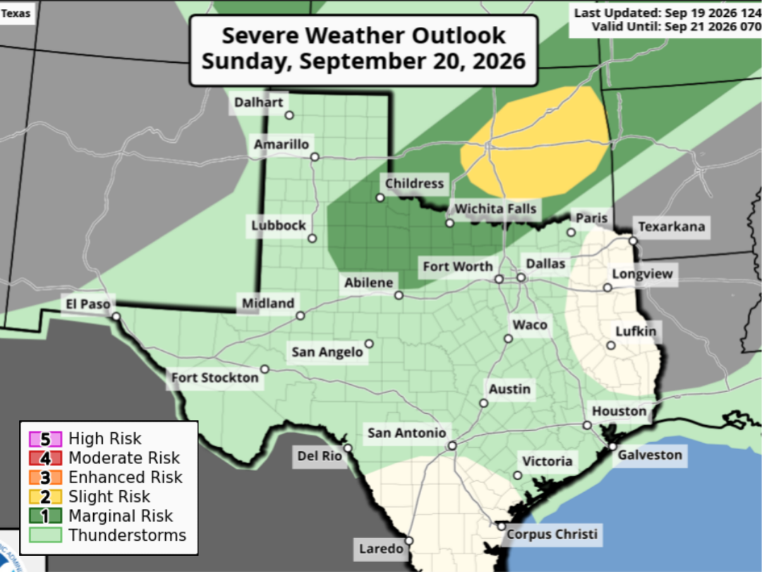
The weak cold front will move through the Texas panhandle and into parts of far North Texas by Sunday afternoon and evening. Along the front, scattered thunderstorms are expected to develop, especially in the area from Lubbock eastward to Wichita Falls and just to the northwest of the DFW metroplex.
This region in North Texas is also under a Level 1 of 5 risk of severe thunderstorms on Sunday, meaning that a few storms could produce large hail and damaging wind gusts.
Another round of scattered storms is also expected over this region Monday afternoon and evening. Yet again, a few storms could be strong to severe. Temperatures will also turn noticeably cooler in the Dallas area, dropping from near 100 degrees on Sunday down into the low 90s by Tuesday.
The cold front is likely to stall out across North-Central Texas, likely at least 150 to 200 miles north of the San Antonio metro area. Because of that, temperatures are not expected to change much over the next few days.
On Sunday, San Antonio will enjoy a pleasant morning with low temperatures in the mid-70s. By the afternoon, high temps are expected to rise between 96 and 98 degrees under partly to mostly sunny skies. High humidity will also cause heat index values to reach as high as 103 degrees. An isolated storm is not out of the question, but overall rain chances will only be near 10%.
Similar conditions are expected on Monday and Tuesday, as high temperatures will rise to around 97 to 98 degrees each day — nearly 10 degrees above average for this time of the year.
As the weak front meanders slightly closer to the region, chances for scattered showers and storms will increase slightly. Overall rain chances will be around 20% in San Antonio both Monday and Tuesday. While the overall odds for rain are rather low, the storms that do form could produce brief downpours, lightning, and gusty winds.
Extended forecast: Conditions will stay hot and humid across South Texas through the end of the week, with high temps hovering in the mid- to upper 90s through Friday. An isolated shower or storm can’t be ruled out, but rain chances will drop to around 10%.
By the end of September and into early October, some long-term weather models are suggesting that the weather pattern could turn more active, leading to cooler temperatures and higher chances of rain. Be sure to stay with expressnews.com/weather for continued updates.