
Humidity-driven heat index values could still reach the triple digits in Austin by 3 p.m. Friday, according to the National Blend of Models, a composite weather forecast model.
National Blend of Models/Pivotal Weather
If we can just hold out for one more hot and humid weekend, Austin can expect a rainy cold front — a true fall cold front — to bring moisture to our parched landscape in Central Texas. A good soaking from a Pacific cold front might be just what we need as the drought in Texas worsens in Travis County and other parts of the state.

What’s the Friday forecast?
Austin on Friday is shaping up to be mostly sunny with daytime temperatures likely to flirt again with 100 degrees. That’s about 10 degrees warmer than normal for Sept. 25 in Austin. Humidity also will continue to intensify the unseasonable heat, driving the heat index or “feels like” temperature, to 101. While nighttime skies turn partly cloudy, overnight temperatures are expected to stay above 75, which also would be several degrees above normal.
Article continues below this ad
An upper-level ridge of high atmospheric pressure will continue to dominate Central Texas weather Friday and over the weekend, keeping the region hot and largely rain-free, according to the National Weather Service.
What’s the weekend weather forecast?
Expect one more weekend “to feel like an endless summer rather than the start of fall,” the weather service said in a forecast bulletin Thursday. The ridge of high pressure will shift to the south and west, preventing any chances for rain Saturday.
Article continues below this ad
“The air mass over South-Central Texas remain about the same with low-level (air) flow from the east to southeast,” the weather service said. “Temperatures will will also be stagnant through the weekend.”
Although Austin on Saturday should be partly sunny, afternoon temperatures are still likely to approach 100 degrees again. As southerly winds of 5 mph pick up Saturday night, skies will become cloudier. Overnight temps should bottom out at a balmy 76 degrees before sunrise Sunday.
Forecasters said the upper-level high pressure system will have shifted far enough for rain chances to arise, but not for Austin just yet. Instead, Sunday and Monday in Austin will be mostly sunny and hot, with a temperatures reaching 99 degrees.
When does the rain arrive in Central Texas?
“Tuesday (weather forecast) models are showing the first real front of the season moving into Texas,” the weather service said in its forecast bulletin. “This will bring chances for widespread rain Tuesday and Wednesday.”
Article continues below this ad
Austin on Tuesday has a 20% chance of showers and thunderstorms on an otherwise partly sunny day, with temperatures ahead of the cold front peaking at 98 degrees. At night, those rain chances ramp up to 40% under overcast skies.
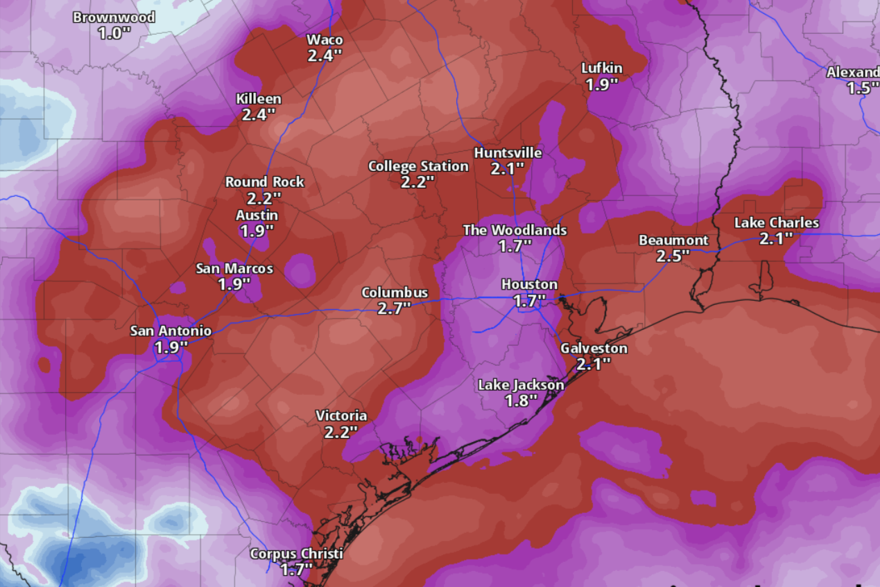
As much as 2 inches of rainfall could accumulate in Austin next week, between Tuesday and Thursday, according to some forecast models.
National Blend of Models/Pivotal Weather
“The front will move through (South-Central Texas) Tuesday night and early Wednesday,” the weather service said. “Northerly to northeasterly winds behind the front will bring cooler, drier air.”
By Wednesday, Austin’s rain chances will be up to 50% and as much as 2 inches of rainfall could accumulate next week, between Tuesday and Thursday, according to some forecast models.
Article continues below this ad
The U.S. Drought Monitor released its data Thursday showing the levels of drought across Texas, including a reappearance of extreme drought in Travis and Williamson counties.
U.S. Drought Monitor/National Drought Mitigation Center
Could the rain help our drought situation?
While 2 inches of rain over a few days is what we can expect so far, a little bit of rainfall will go a long way these days in Central Texas.
Article continues below this ad
Extreme drought, the second-highest level of drought on the scale used by the U.S. Drought Monitor, has returned to Travis and Williamson counties for the first time since June. Typically, extreme drought can mean an area experiences an increased risk of large wildfires, soil has large cracks and soil moisture is very low, reservoir levels drop significantly and surface water is nearly dry.
Extreme drought is primarily along and east of Interstate 35 and covers about 22% of Travis County and about 14% of Williamson County.
Severe drought, the next lowest level of drought, covers most of Williamson County, or about 72%. In Travis County, severe drought is mostly east of MoPac Boulevard (Loop 1), where it covers about 39% of the county.
The remaining 39% of Travis County is in moderate drought, which is the lowest level as measured by the U.S. Drought Monitor.