
Saturday will start mostly cloudy across Central Texas, with morning lows in the lower to mid-70s. It’s one of those mornings where you can go either way on the hot or iced coffee.
By noon, temperatures will climb into the upper 80s, with humidity making those temperatures feel more like 90 or 91 degrees. If you’re headed to the ballpark or soccer fields for Saturday games, the clouds should stick around through early afternoon, offering at least a little relief from the September sun.
Then, as the clouds break and the afternoon sun takes over, temperatures will climb into the upper 90s. The upside: Humidity will be lower. While it is still hotter than normal, the “feels like” temperature should stay around 100 degrees. Winds will remain light throughout the day, generally out of the south and southeast at 3 to 8 mph.
Expect a slight shift in the weather pattern Sunday as the upper-level ridge of high pressure that’s been anchored over Texas begins to move south and west of the state.
Sunday morning will start partly cloudy to mostly sunny, with temperatures in the middle to upper 70s and light winds. Sunshine will continue through the afternoon, although clouds will gradually increase late in the day and into the evening. We’ll have a chance for a few spotty showers and thunderstorms across parts of the Hill Country, mainly west of Austin.
Temperatures will climb into the upper 90s to near 100 degrees, with humidity driving “feels like” temperatures to between 102 and 104 degrees. The big question is whether Sunday will mark our 50th day of triple-digit temperatures. We’ll have to wait and see.
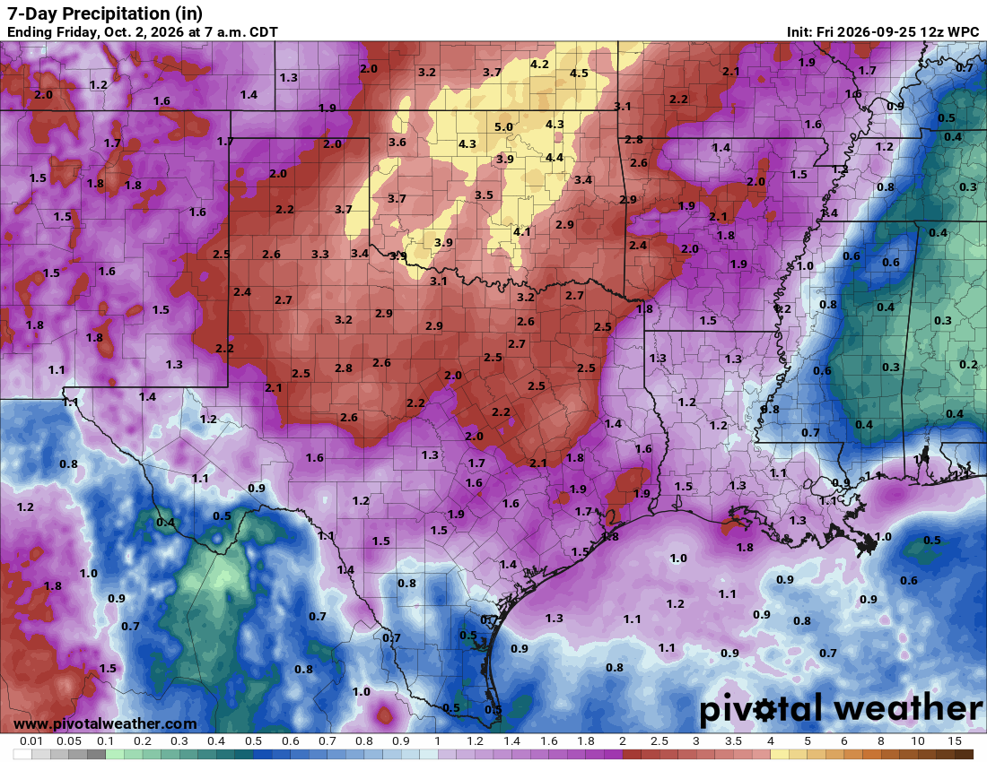
All eyes are on the first cold front of fall, which is expected to bring major relief to scorched Central Texas by midweek. As the upper-level high pressure shifts away from the Lone Star State, rain chances will begin to increase, with a slim shot at isolated showers and thunderstorms Monday and Tuesday. However, the air mass will remain relatively unchanged, with morning lows in the upper 70s and afternoon highs in the upper 90s through Tuesday.
Then, a big change arrives. A Pacific front, combined with remnant moisture from Hurricane Polo churning in the Pacific Ocean, will move through Texas, bringing widespread rain beginning Tuesday and continuing through much of the week.
Forecast models are not consistent on when the front will move through, but rain chances and cloudiness will ramp up, and temperatures will dip into the upper 80s and low 90s by Wednesday and through the rest of the week.