
Peak daytime temperatures on Sunday will be near 100 degrees for most of Central Texas.
Pivotal
We are just days away from a cold front that could put an end to our 100-degree days for 2026.

Central Texans are ready to celebrate, but as we all know, Texas weather can flip from one extreme to another in a matter of days. That’s why we’re keeping a close eye on the changing weather pattern expected by the middle of next week, and the potential for heavy rain and flash flooding in parts of the state.
Article continues below this ad
We are still on pace for a big pattern shift next week, with some much needed rain and cooler temps very possible. What we are still watching for is timing, as a slower setup could have some flooding concerns. Stay up to date with the latest forecast at https://t.co/s9JpN9yVKL! pic.twitter.com/mcqPI5VvDO
— NWS Fort Worth (@NWSFortWorth) September 25, 2026
Will this be our last triple digit day of the year?
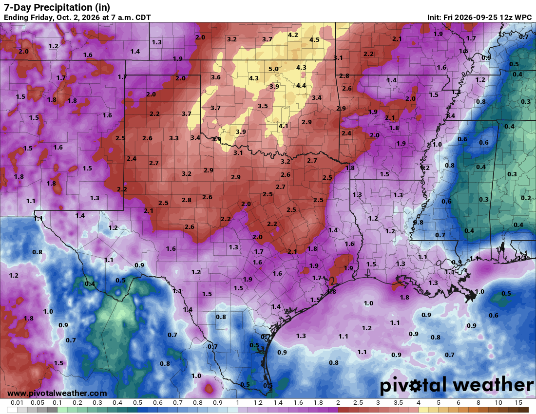
Projected cumulative rainfall through next Friday morning will range from 1 to 2 inches with isolated higher amounts in Central Texas.
Pivotal
Hopefully, our last 100-degree day of the year will be recorded Sunday. We’ll see plenty of sunshine and afternoon temperatures ranging from the mid-90s in the Hill Country to around 100 degrees along the Interstate 35 corridor, with upper 90s farther east toward the Coastal Plains.
Article continues below this ad
Monday will be hot as well, but with more clouds filtering in, actual air temperatures may stay just shy of the 100-degree mark. However, the heat index will climb to between 101 and 104 degrees.
The rest of the week will be cooler with the rain and cloudy skies; most high temperatures will be closer to our late-September average in Austin of 88 degrees.
What’s next after the heat?
Once the heat breaks, our attention will quickly turn to rain. The latest forecast models point to a more active weather pattern beginning Tuesday afternoon, bringing the potential for much-needed rain and thunderstorms.
Article continues below this ad
The latest Texas data from the U.S. Drought Monitor shows 84% of the state is experiencing drought, with more than 18 million Texans living in areas affected by drought. That’s up from 81% last week.
In Central Texas, extreme drought, the second-highest level of drought, has expanded along and east of Interstate 35 in Williamson and Travis counties, as well as into parts of far western Bastrop County.
Extreme drought is showing up in Central Texas for a small area east of I-35 in Williamson and Travis Counties.
National Weather Service
To break that down even further, extreme drought now covers 14% of Williamson County, 22% of Travis County and 5% of Bastrop County. The dry conditions are also reflected in the number of burn bans across the state. As of now, 216 of 254 Texas counties have local burn bans in place, including counties along the Interstate 35 corridor.
Article continues below this ad
The increasing drought across the state has prompted 216 of the 254 Texas counties to issue burn bans.
Texas A&M Forest Service
With all of this in mind, it’s nice to see rain in the forecast. After such a hot and dry stretch during the late summer, the incoming rain could bring some much-needed relief to the Lone Star State.
When will the rain arrive and how much can we expect?
The upper-level ridge of high air pressure that was overhead this weekend will shift south and west, opening the door for our next weather maker. A cold front, along with remnant tropical moisture from the Pacific, will begin slowly moving into Texas on Tuesday, increasing the threat of showers and thunderstorms that could stick around for several days.
Article continues below this ad
“Recently, medium-range guidance has started to slow the progression of the upper-level low, which could increase the potential for prolonged rainfall and flooding concerns by the end of next week,” meteorologists from the National Weather Service wrote.
Overall, the latest forecast has Central Texas receiving between 1 and 2 inches of rain by Friday with higher amounts in North Texas where Dallas could see up to 3 inches of rain.
We are still several days out from the event, so it’s important to stay aware of the latest forecasts. Check back frequently with statesman.com/weather and follow instagram.com/wassonweather, facebook.com/MeteorologistMaryWasson or x.com/Mary_Wasson for forecast updates.
Article continues below this ad