
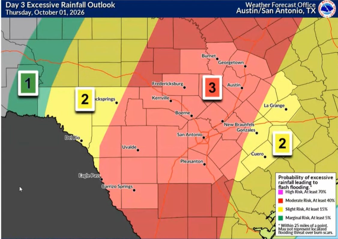
In the coming hours and days, a strong Pacific cold front will sweep across the Lone Star State and could bring troubling storms. Even the more conservative forecasting agencies are warning of risks of life-threatening flooding and 8 inches or more of rain.
“We are watching a Pacific cold front that will bring widespread rainfall across South Central Texas sometime Wednesday night through Friday,” Jason Runyen, the warning coordination meteorologist for the National Weather Service Austin-San Antonio office, warned during a Tuesday morning briefing.
Runyen noted that the heaviest onset will likely arrive between Wednesday and Thursday evenings.
However, confidence in the timing remains low. The greatest risk (Level 3 of 4) centers on flash flooding, with forecasters outlining a medium confidence in widespread rainfall. But the national agency warns of a lower risk of severe storms, including large hail, damaging winds or even a tornado.
“We do have the concerns for minor to moderate river flooding across some of our river basins, depending on exactly where the heavier rainfall sets up,” Runyen said. “There is a severe risk with this, albeit a low risk, beginning Wednesday night and continuing through the day Thursday and Thursday night.”
This cold front from the west is slated to breach West Texas midday Wednesday, but storm clouds should hold off over South Central Texas on Thursday. It’s a slow-moving cold front, which is why the rain could continue to fall over the region for several days.
Though forecasters warn that early-fall cold front models have difficulty estimating the exact speed or placement of impact, the front and its accompanying gloomy weather could reach the Coastal Plains (the Gulf Coast) by Saturday, where it is expected to stall out.
“We’ll be watching for continual rainfall even behind the front across South Central Texas during the day Saturday and even into Sunday,” Runeyn said.
The National Weather Service is calling for 2 to 4 inches of rain across South Central Texas, from Llano through the Hill Country to San Antonio and down to Carrizo Springs, through Friday morning. But some of that rainfall could occur quickly, inundating rivers, streams and runoff channels in a short period of time.
The current total projects also exclude any rain that may continue to plague the area on Friday or over the weekend if the Pacific cold front stalls and continues to affect the area. In the worst-case scenarios, Runyen said pockets of 5 to 8 inches – or even higher in some areas – could fall within the same timeframe.
While there is a low-level risk of flooding and heavy rain in the greater San Antonio-Austin area on Wednesday into Thursday morning, the greatest risk (Level 3 of 4) affects those major metros and surrounding Texas Hill Country towns between Thursday afternoon and Friday morning.
Ultimately, there is a strong risk of life-threatening flooding across South Central Texas and a large portion of Texas in the next 48 to 72 hours. Experts are urging residents to stay weather-aware and have a plan in place.