
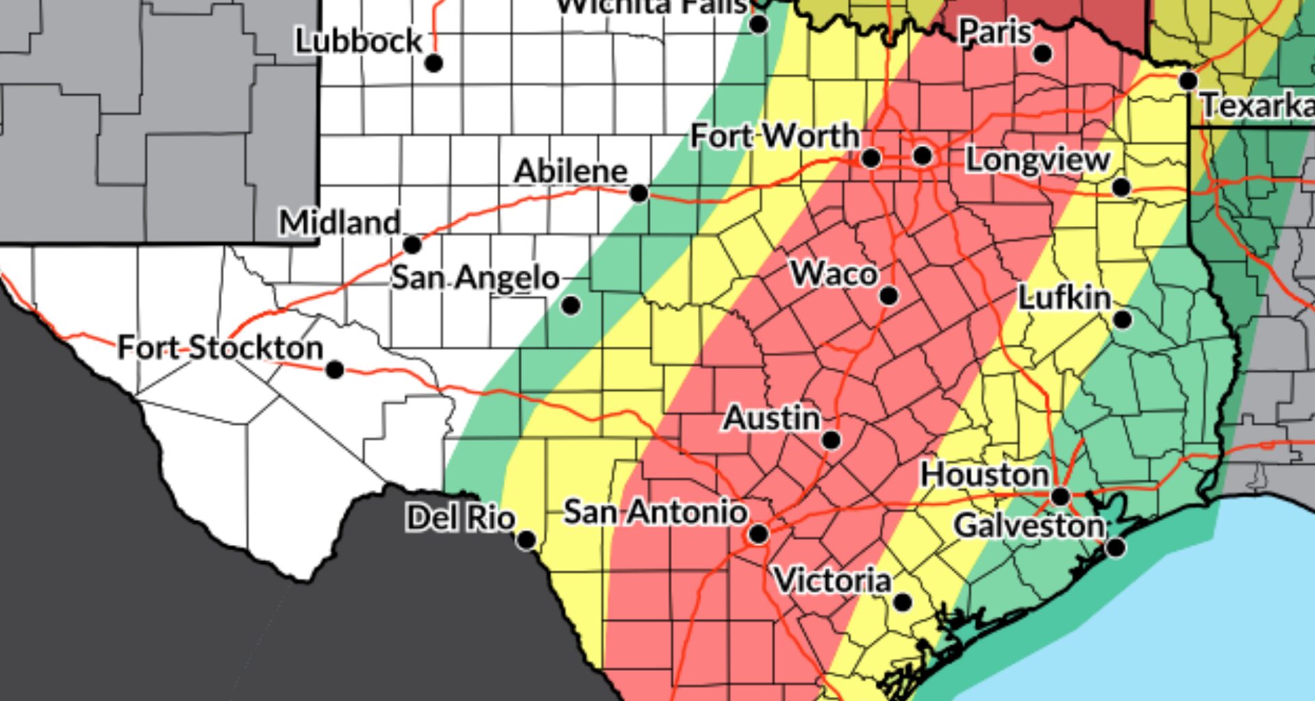
Thursday’s flood risk in Texas is highest along the Interstate 35 corridor from the Dallas-Fort Worth area to San Antonio and Laredo. Here, rainfall totals of up to 4 inches could cause flooding.
NOAA’s Weather Prediction Center
While Houston’s latest rainfall projections have dropped, the heaviest rainfall and greatest risk for flooding remain northwest of the city through Friday.
The first wave of rain moves through Thursday into Friday, followed by another chance for tropical downpours along the Gulf Coast late Saturday into Sunday. Potential rainfall totals have come down, but they could still vary sharply across Southeast Texas.
What’s happening now
A slow-moving line of showers and thunderstorms is advancing east across North and Central Texas early Thursday, bringing heavy rainfall that has triggered flood alerts from west of San Antonio to the Dallas-Fort Worth area. This line of storms will reach the Interstate 35 corridor Thursday morning, and approach Southeast Texas likely late Thursday afternoon or evening.
Article continues below this ad
Storms continue to slowly shift east time. Several Flash Flood Warnings in effect for the Hill County. With the slower progression east, this has pushed back the timing of the heavy rainfall threat into this afternoon for the I-35 corridor. https://t.co/NjU76KWJ5j
— NWS Austin/San Antonio (@NWSSanAntonio) October 1, 2026
The level 3 of 4 risk, or at least a 40% chance, of flooding rainfall blankets the I-35 corridor, but extends east to roughly along a line from College Station to La Grange.
Thursday into Friday: Heaviest rainfall expected northwest of Houston
As the storms reach Southeast Texas, rain is expected Thursday afternoon across parts of the Brazos Valley, with some activity possibly closer to Houston in time for Thursday evening’s commute.
More downpours are expected overnight and could continue into early Friday, possibly slowing down morning commuters.
Article continues below this ad
With lower rainfall totals expected across much of Southeast Texas, most rain should be beneficial. Through Friday afternoon, totals could reach an inch to 2 inches in the Brazos Valley and Piney Woods, with about a half-inch to 2 inches elsewhere. Stronger storms could still drop 2 to 3 inches in a short time.
This map shows projected cumulative rainfall totals through Sunday morning across Southeast Texas. Heavy rainfall Thursday through Friday could bring 2 to 4 inches of rain from Austin to San Antonio, while Houston may see only an inch to 2 inches.
NOAA’s Weather Prediction Center / Pivotal Weather
Rainfall across Southeast Texas, especially along the coast, is uncertain beyond Sunday as a surge of tropical moisture arrives. This forecast from NOAA’s Weather Prediction Center keeps the heaviest rain just offshore of the upper Texas Gulf Coast through much of next week.
NOAA’s Weather Prediction Center / Pivotal Weather
Heavier downpours could cause runoff and localized street flooding, especially in urban areas and places with poor drainage. Creeks and bayous are not expected to overflow. Never drive through flooded roadways.
Late Saturday into Sunday: Coastal rain threat increases
The front responsible for this week’s rain is expected to linger near the coast this weekend.
Article continues below this ad
Moisture gathering along the boundary, along with a developing coastal system, could bring another period of heavy rainfall late Saturday into Sunday. Areas south of Interstate 10 could receive another inch or two from Saturday through early next week, bringing total rainfall from Thursday through early next week to 2 to 4 inches.
Higher totals are possible near the coast, though some of the heaviest rainfall may stay offshore, limiting how much reaches coastal communities.
Early next week: A front brings drier, cooler weather
A cold front is expected to move through Southeast Texas around Monday or Tuesday, bringing drier air and a noticeable, though modest, drop in temperatures. Houston could see overnight temperatures dip below 70 degrees on several days next week.
Article continues below this ad
Rain chances should diminish behind the front, though a few showers could linger near the coast.