
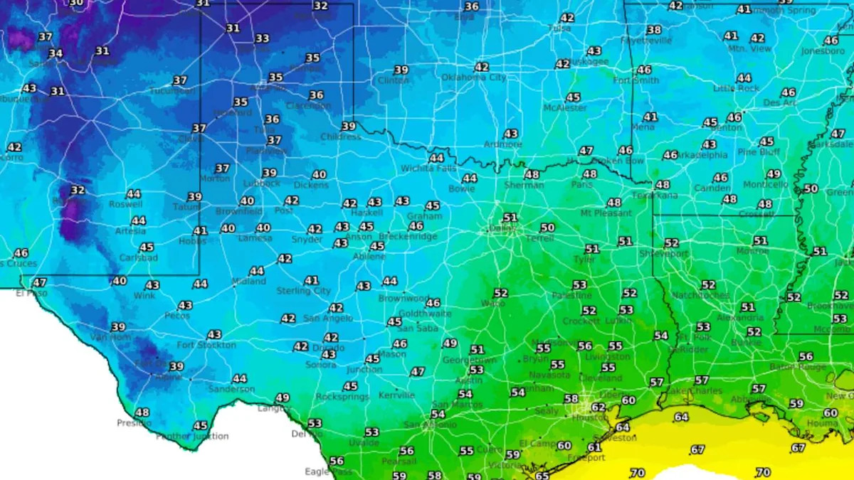
Houston’s strongest taste of fall arrives this weekend, but for parts of Texas, the late-week cold front could make it feel more like winter.
The front will reach Southeast Texas Friday, bringing a noticeable change, though its effects will vary widely across the state. Farther north, the same system could bring a sharper taste of winter. In Houston, the main story will be a cooler, more comfortable weekend.
Houston has one more 90-degree day this week
Before winds shift out of the north behind Friday’s front, Houston still has one more steamy day to get through Thursday.
After starting in the low to mid-70s, high temperatures should reach 90 degrees in Houston, coming just shy of the 92-degree daily record set in 2019. A few isolated showers or thunderstorms could pop up during the afternoon or early evening, though most neighborhoods will stay dry and mostly sunny.
By late Thursday, Houston’s fall front will stretch from roughly the Dallas-Fort Worth metroplex to San Angelo.
Cold front blows in Friday morning
You may be disappointed if you step outside Friday morning expecting a dramatic drop in temperature or humidity.
While Friday’s cold front will push through the Houston area early in the day, likely before most people start their day, the cooler and drier air takes time to move into Southeast Texas. A passing shower or thunderstorm also could develop along the front’s leading edge, especially near the coast.
SIGN UP:
As northerly winds pick up Friday afternoon, dew points should drop from near 70 degrees Friday morning to the upper 40s and low 50s by early Saturday. The strongest wind gusts, between 25 and 35 mph, are expected from Friday afternoon into early Saturday.
Who in Texas will see temperatures drop into the 30s?
The coldest air will reach the Texas Panhandle hours before the cold front reaches Houston.
Panhandle temperatures could fall into the upper 20s to mid-30s, potentially bringing the first frost or freeze of the season. Temperatures will not be quite as chilly farther south and east, with lows in the 30s and 40s across parts of West and North Texas, and mainly in the 40s and 50s in Central Texas. Houston and Southeast Texas should stay mostly in the 50s.

The European forecast ensemble model shows the probability of temperatures reaching 40 degrees or lower early Saturday. The highest odds are across the Texas Panhandle, with probabilities decreasing farther south and east. (WeatherBELL)
Not surprisingly, the Panhandle often gets its first cold air well before Southeast Texas. The average first freeze in Amarillo typically occurs around Oct. 26, so this weekend’s chill is a few weeks ahead of schedule. For Houston, the average first freeze typically arrives around Dec. 9.
Houston’s weekend temperatures trend cooler
Models continue to trend cooler for Houston behind Friday’s cold front.
Temperatures on Saturday may only reach the low 70s in Houston as gusty northerly winds funnel cooler air into the region. Communities north of Houston, including Huntsville and Livingston, may spend much of the day in the upper 60s. The last time Houston’s last daily high temperature was below 70 degrees was May 1.
Saturday night into Sunday morning will likely be Houston’s coolest stretch, with morning lows falling into the 50s for the first time since May 4. By Sunday afternoon, easterly winds will bring warmer, gradually more humid air. Highs should reach the mid- to upper 70s across most of Southeast Texas.
Subscribe
There’s more to Houston with the Chronicle. Subscribe today for just 25¢.
This article originally published at Houston’s next cold front could bring 30s in parts of Texas this weekend. Here’s where..