
The tropical waters across the central and eastern Pacific Ocean continue to warm up rapidly, signaling that El Niño is continuing to strengthen.
According to the latest update from the National Oceanic and Atmospheric Administration, sea-surface temperatures have already reached 2.1 degrees Celsius above average. Anything more than 2 degrees warmer than normal is considered by the weather agency to be a “very strong” El Niño, also unofficially known as a “super” El Niño.
That already makes this the third-strongest El Niño recorded in the satellite era – which dates back to 1950 – trailing only the El Niño events of 1997-98 and 2015-16. However, forecast models show that the current El Niño event will continue to strengthen through the end of the year, potentially becoming the strongest on record by December.
What does El Niño mean for Texas?
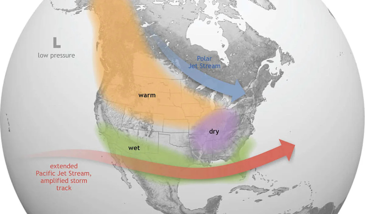
An active El Niño in the Pacific triggers a significant shift in weather patterns across the globe. In North America, El Niño typically forces the Pacific jet stream to shift southward, resulting in a more active storm track and more frequent cold fronts across the southern United States.
BUSTING El NIÑO MYTHS: 5 things El Niño isn’t: Separating fact from fiction about the weather phenomenon
For Texas, that shift in the jet stream typically means below-average temperatures, less sunshine, and more precipitation than normal. The strongest effects tend to occur during the winter months, from December through February.
The biggest change for Texas is the increase in winter precipitation. Weather history shows that strong El Niño events can bring double the typical rainfall to parts of the state. But which Texas cities are the most affected by El Niño? We looked through yearly weather records across different sections of the state to find out.

Sea-surface temperatures cross the central and eastern pacific ocean along the equator has grown to 2 to 4 degrees Celsius above average, signaling a super El Niño. (National Oceanic and Atmospheric Administration/WeatherBELL)
How much rain is coming?
North Texas: Since 1950, there have been 27 winters with an active El Niño in place. During those winters, the Dallas-Fort Worth area has averaged 6.91 inches of rain – just 7% higher than during a non-El Niño winter. While that is still a slight increase, North Texas is historically the least influenced by the presence of El Niño.
Southeast Texas: The effects of El Niño become more pronounced farther south. In Houston, El Niño winters have brought an average of 11.34 inches of rain, nearly 20% higher than during non-El Niño winters.
If we exclude the “weak” El Niño events, the difference becomes even more significant. During the nine moderate to strong El Niño events since 1950, Houston’s average wintertime rainfall has been 39% higher than during winters without El Niño.

The chances of a “very strong” or a so-called super El Niño persisting into early next year are fairly high, according to NOAA’s Climate Prediciton Center. (Climate Prediction Center/National Oceanic and Atmospheric Administration)
South-Central Texas: The effects of El Niño in this section of the state are huge, significantly changing the typical winter climate. In Austin, wintertime rainfall has increased by 38% during El Niño events of any strength, with a 62% increase during moderate-to-strong El Niño events.
The numbers are even more striking in San Antonio. During an active El Niño, the Alamo City averages 6.88 inches of rain during the winter, nearly 60% more than during a non-El Niño winter. During strong El Niño events, that number jumps to 9.88 inches – more than double the typical amount.
In Laredo, strong El Niño events have resulted in an average of 4.48 inches of wintertime rainfall, a 149% increase over the non-El Niño average of 1.8 inches.
West Texas: The difference continues to be staggering across West Texas, a region that is typically quite dry during the winter. In Lubbock and El Paso, El Niño has historically brought about 50% to 70% more wintertime rainfall, while strong El Niño events have resulted in more than double the typical rainfall.
The effects of El Niño are less pronounced in the Panhandle. Still, Amarillo has recorded about 20% more rainfall when El Niño is in place.
The strengthening El Niño is likely to bring significant changes to Texas’ weather, especially when it comes to wintertime rainfall. South-Central and West Texas are likely to see the largest increases in moisture, while more subtle increases are expected elsewhere across the state. However, a strong El Niño does not guarantee heavy rainfall – it only makes it more likely.
Subscribe
There’s more to Houston with the Chronicle. Subscribe today for just 25¢.
This article originally published at Super El Niño winter is coming: Here’s which Texas cities will likely be most affected.