
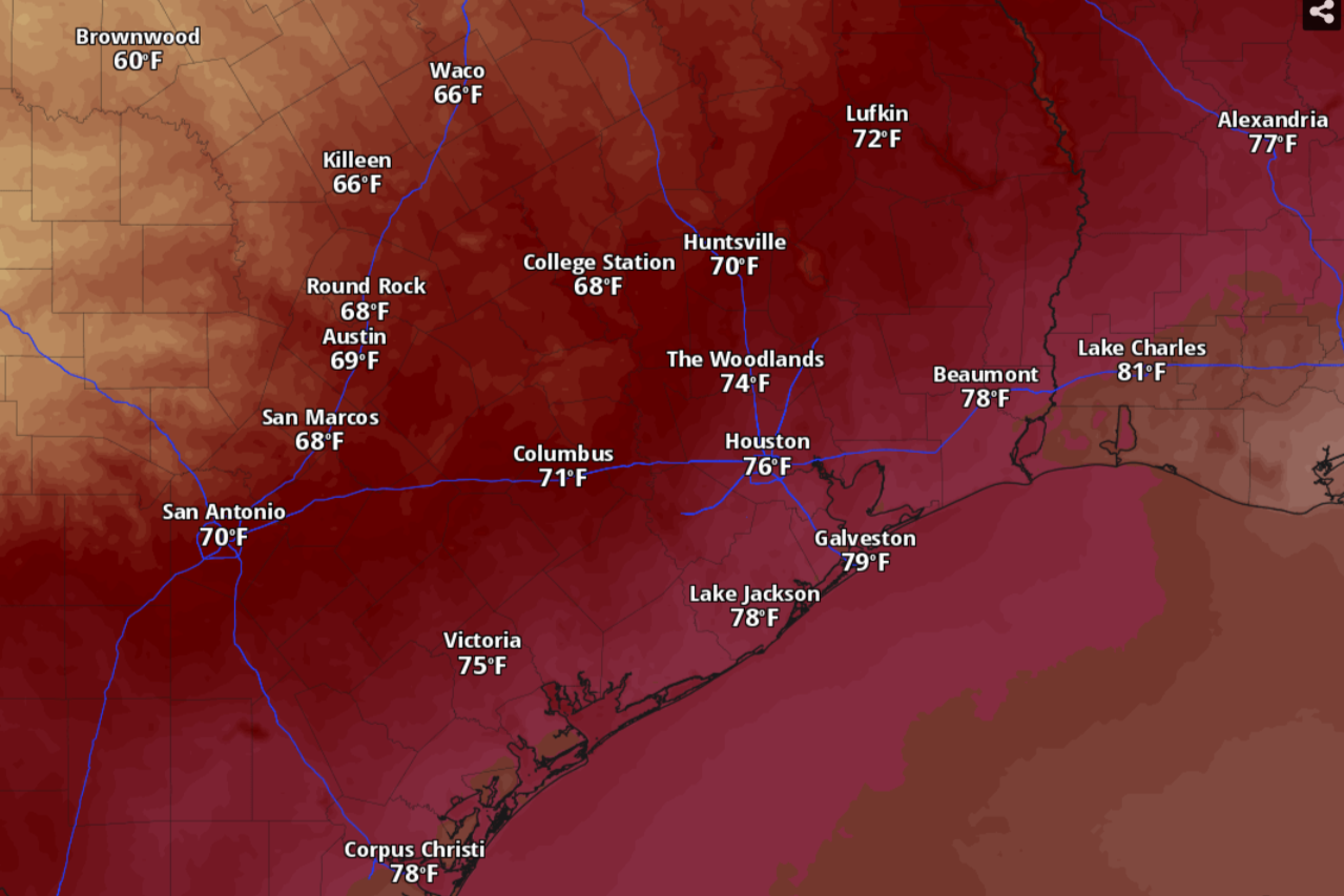
Temperatures in Houston will likely peak only in the mid-70s by 3 p.m. Friday, according to the National Blend of Models, a composite weather forecast model.
National Blend of Models/Pivotal Weather
A much-anticipated fall cold front has blown across Texas and the cooler air mass behind it was at Houston’s doorstep Friday morning. Other parts of the state, including the urban centers along the Interstate 35 corridor, such as San Antonio and Austin, have already seen predawn temperatures drop by at least 15 degrees from the previous morning.
With strong winds kicking up in the wake of the cold front, now would be a good time to secure outdoor items that could be lifted: We’re looking at you, patio furniture and Halloween yard decorations.
With Texas weather flipping from summer-like heat to true autumn chills in less than 24 hours, here’s a timeline of Houston temperatures with the passage of the season’s strongest cold front so far:
Article continues below this ad
Friday afternoon
After some brief opportunities for rain in the morning, skies over Houston are shaping up to be partly sunny, according to the National Weather Service. That should allow afternoon temperatures to climb into the mid-70s. But with the strong cold front blowing through the area, that’s about as warm as it will get on Friday.
The bigger weather issue will be the gusty north winds at 10 to 15 mph that will increase to 15 to 20 mph in the afternoon. Gusts could be as strong as 35 mph.
The weather service on Friday warned that hazardous marine conditions are expected and that a gale warning was in effect Friday and into Saturday for strong north winds and building seas. On land, the weather service issued a wind advisory Friday until 1 a.m. Saturday for much of Southeast Texas along and west of Interstate 45, citing sustained winds of 20 to 30 mph and gusts as strong as 40 mph.
Article continues below this ad
Friday night
Expect skies to turn partly cloudy at night, with temperatures bottoming out around 52 degrees before dawn Saturday. The breezy north winds will persist at 15 to 20 mph, along with gusts as strong as 30 mph, forecasters said.
Saturday morning
“It’s shaping up to be a great weather weekend with lows in the 40s and 50s and highs in the 70s,” the weather service said in a forecast bulletin posted online Friday. “One note for those with outdoor plans … be extremely careful with anything that might cause a spark or flames — the fire danger
will be elevated with dry air in place.”
The Texas A&M Forest Service fire danger forecast has East Texas and parts of Southeast Texas under a heightened risk of fast-spreading wildfires on Friday and Saturday.
Texas A&M Forest Service
The strong north winds, low humidity and dry vegetation in Southeast Texas have set the stage for an increased risk of fast-spreading wildfires, particularly east of Interstate 45, according to the Texas A&M Forest Service.
Article continues below this ad
“Though breezy to windy conditions are likely, RH (relative humidity) values in the 30-40% range will be above red flag warning
criteria,” forecasters said. A red flag warning is issued when fire weather danger reaches a critical level. “That said, caution is strongly advised with outdoor burning.
Saturday afternoon
Look for sunny skies Saturday but the chilly air mass behind the cold front will be settling into the region. Houston’s afternoon peak temperatures aren’t expected to get above 70 degrees or so. The blustery north winds will continue to blast through Southeast Texas at 10 to 15 mph, with gusts as strong as 25 mph.
Saturday night
Although nighttime skies will remain mostly clear, the dry air will allow the heat absorbed by the ground during the daytime to then escape into the atmosphere at night. Expect overnight to predawn temperatures, even in the urban heat island of the Houston metro area, to drop to as low as 49 degrees, while the north winds will add bite to those temps.
Article continues below this ad
By 7 a.m. Sunday morning, Southeast Texas would have experienced its coldest temperatures of the week, with readings sinking into the upper 40s across Houston’s northern suburbs.
National Blend of Models/Pivotal Weather
Sunday
After the chilliest morning that we will experience this week, Sunday will mark the beginning of the end of the coldest temperatures. Daytime temps will climb from a low of 49 around 6 a.m. to a high of 74 around 4 p.m. At night, temperatures will slide, retreating into the 60s and upper 50s before settling at around 55 degrees by 6 a.m. Monday.
Monday
Warmer temperatures are set to return next week, forecasters said, but we should expect them to stay limited to the season’s climate-averages.
Article continues below this ad
Monday in Houston should be mostly sunny, with morning temperatures starting out in the 60s before peaking in the afternoon at 78 degrees around 4 p.m. More clouds are expected at night, and the extra atmospheric moisture should help keep overnight temperatures above 60 degrees.
Tuesday
The weather service said high atmospheric pressure behind the font will track eastward early next week, leading to “a gradual return to mainly seasonable temperatures.”
“Though the center of the ridge should be positioned to our east, it’s expansive enough where we’ll still be on its outer periphery most of the week,” the weather service said in its forecast bulletin. “Prevailing east winds should recycle some drier air into the region from time to time and keep the Gulf moisture return and associated rain chances mostly in check.”
Houston on Tuesday can expect mostly sunny skies with temperatures rising into the 70s by mid-morning and reaching 84 degrees by 3 p.m.