
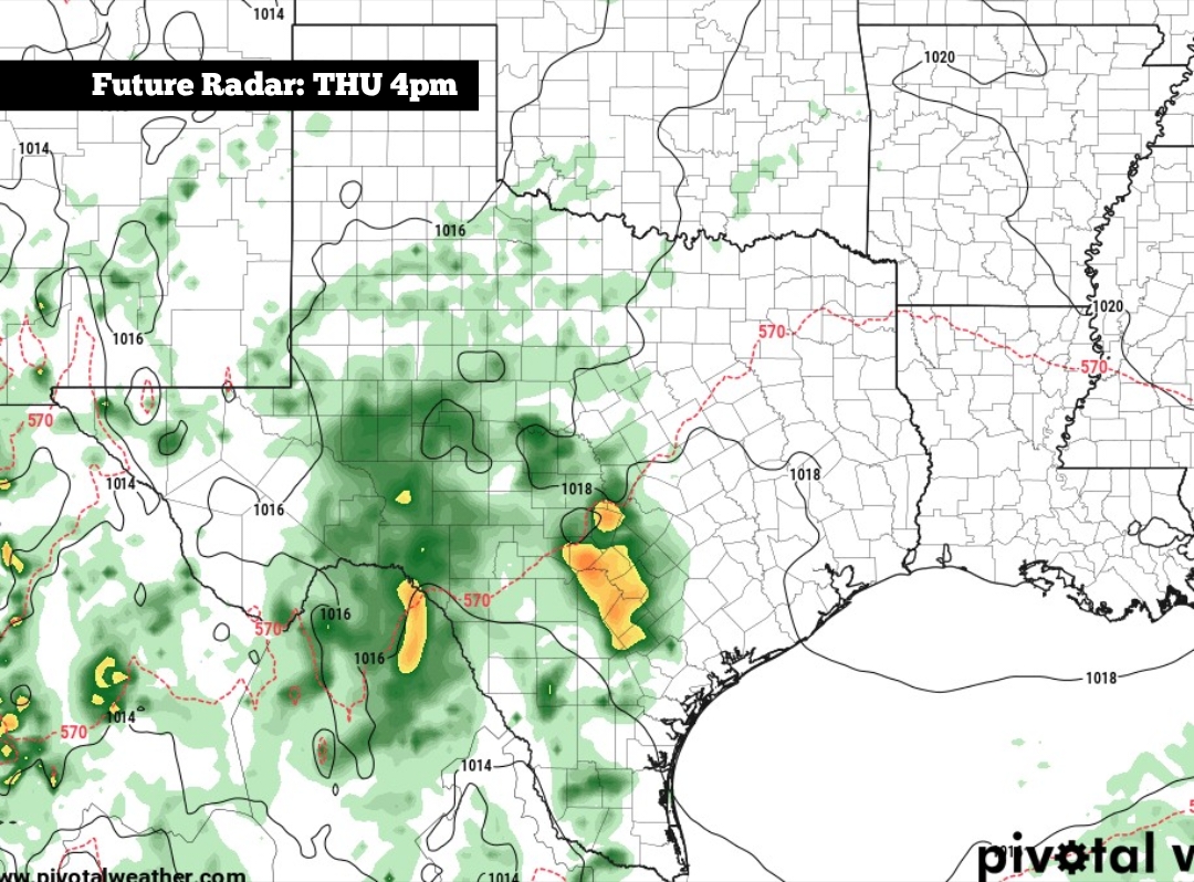
Shown is the potential future radar at 4 p.m. Thursday, as Pacific moisture moves into Texas.
Pivotal Weather
After what has been a very dry past few weeks, a more active weather pattern will set up across South-Central Texas this week. High pressure is moving off to the east, and it will be replaced by a broad low-pressure system over the western U.S. This atmospheric disturbance, along with the remnants of Hurricane Vance, which will transport higher levels of moisture into the Lone Star State.

This increased moisture will bring lots of cloud-cover to the region, as well as a several opportunities for showers and thunderstorms. But will the rain chances end by Halloween night? Here’s a breakdown of what to expect this week.
Article continues below this ad
Monday’s forecast
Cool and comfortable weather is expected across South-Central Texas early Monday, as low temperatures will hover in the upper 50s to low 60s at 8 a.m. Conditions will warm up steadily during the mid-morning, reaching the mid-70s by 11 a.m.
Shown are the expected high temps across the region on Monday.
Pivotal Weather
By the afternoon, high temperatures are expected to reach the low 80s, likely between 81 and 83 degrees in the San Antonio metro area. The Hill Country will be cooler, with highs in the upper 70s from Kerrville to Fredericksburg.
Article continues below this ad
Skies will be mostly cloudy throughout the second half of the day, but rain chances will stay low. San Antonio will encounter just a 10% to 20% chance of an isolated shower during the late afternoon and evening, with slightly higher chances of showers expected across the Hill Country.
Rain chances rising
Atmospheric moisture will continue to increase Tuesday, bringing higher rain chances across the region. San Antonio will have a 20% to 30% chance of rain during the morning, rising to around 40% in the afternoon and early evening.
Rainfall is expected to stay rather light on Tuesday, with most areas picking up less a quarter of an inch of rain. The rain and cloud-cover will keep temperatures down, with highs likely topping out in the upper 70s.
Article continues below this ad
Rain chances across the region will fall to around 20% on Wednesday, with more sunshine returning to the forecast. Temperatures will rise by a few degrees, with highs in San Antonio reaching the low to mid-80s.
Pacific moisture Thursday: Hurricane Vance is likely to affect Mexico’s southwestern coast during the middle of this week. Although the storm won’t move directly into Texas, much of its remnant moisture is expected to reach the state by Thursday.
San Antonio rain chances will rise to around 60% on Thursday, with some tropical downpours possible from the middle of the day through the evening. The National Weather Service has placed San Antonio under a low-end level 1 of 4 risk of excessive rainfall, meaning isolated flooding will be possible in a few locations.
Article continues below this ad
San Antonio is under a low-end level 1 of 4 risk of flash flooding on Thursday.
NOAA
A higher level 2 risk of flooding has been placed for areas farther west, including Laredo, Eagle Pass, Uvalde and San Angelo.
Will rain end by Halloween?
Scattered showers and storms are likely to stay in the area on Friday, with about a 40% chance of additional rainfall in San Antonio. By Halloween on Saturday, rain chances will drop to around 30%. The decreasing rain chances is good news for trick-or-treaters, but a few scattered showers may still remain possible.
Article continues below this ad
As always, the timing of these weather systems could still shift. Be sure to stay with expressnews.com/weather for continued updates.