
FORECAST HIGHLIGHTS
WARM & MUGGY: Monday & Tuesday continue our trend of warm days
WEDNESDAY: Rain stays mainly west of San Antonio
THURSDAY: Scattered storms, one or two could be strong
FORECAST
MONDAY, TUESDAY, AND MOST OF WEDNESDAY
Expect warm & muggy conditions. You’ll notice quite a bit more cloud cover, especially in the mornings. Highs will be in the 80s.
On Wednesday, an area of low pressure will begin to generate rain, mainly for areas west of San Antonio. Storms will also be possible. This activity will move closer to San Antonio by Wednesday night.
Next two days (Copyright 2025 KSAT 12 — ALL RIGHTS RESERVED)
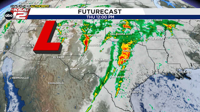
THURSDAY: 60% CHANCE OF RAIN
This is when storm chances peak in San Antonio. This does not mean it’ll be raining all day. In fact, it appears our rain chances will come with a couple of broken lines of showers and storms, with some breaks in between. Either way, a few strong storms will be possible, along with isolated heavy rain. This will drag temperatures down into the 70s.
Chances of rain increase on Thursday (Copyright 2025 KSAT 12 — ALL RIGHTS RESERVED)
CLEARING FRIDAY, QUIET WEEKEND
While a lingering shower or two is possible Friday morning, skies will clear by the afternoon. With the sun returning the to the forecast, temperatures will remain fairly warm. Expect a high in the upper-70s. As of now, the weekend looks quiet and comfortable.
7-Day Forecast (Copyright 2025 KSAT 12 — ALL RIGHTS RESERVED)Daily Forecast
KSAT meteorologists keep you on top of the ever-changing South Texas weather.
QUICK WEATHER LINKS
Copyright 2025 by KSAT – All rights reserved.