
LUBBOCK, Texas (KLBK) — Here is your updated forecast from the KLBK First Warning Weather Center:
 KLBK Weather Headlines
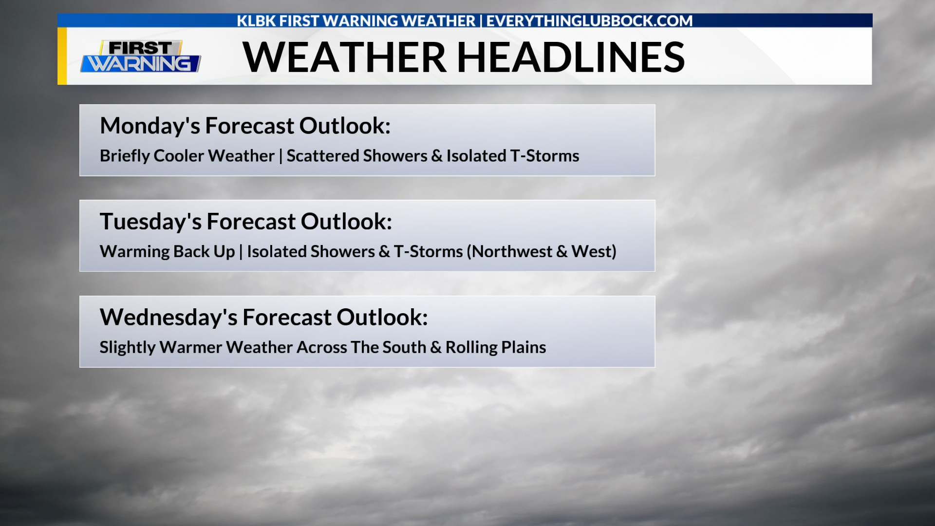
(Valid: Monday, October 13)(Nexstar Media Inc./EverythingLubbock.com/KLBK News)
Today:
Mostly cloudy to cloudy conditions and briefly much cooler weather is forecast across the South Plains and the Rolling Plains on this Monday (Columbus Day/Indigenous Peoples’ Day). Scattered showers and isolated thunderstorms are forecast across most of the South Plains and the Rolling Plains at times through the day. High temperatures will vary and range from the upper 60s to the middle 80s. The wind will be out of the south-southeast 5 to 15 mph with gusts up to 20 mph. The chance for rain is 60 percent.
Sunrise is at 7:51 AM CDT.
Tonight:
Mostly cloudy conditions are forecast this evening. Partly to mostly cloudy conditions are overnight. There is a slight chance for showers this evening and overnight mostly across the northwestern South Plains. Low temperatures will range from the middle 50s to the middle 60s. The wind will be out of the east-southeast 5 to 15 mph. The chance for rain is 20 percent.
Sunset is at 7:15 PM CDT.
Tuesday:
Mostly sunny to partly cloudy conditions and warmer weather is forecast across the South Plains and the Rolling Plains on Tuesday. There is slight chance for showers and thunderstorms across the northwestern and weather South Plains. High temperatures will vary and range from the middle 70s to the upper 80s. The wind will be out of the south-southeast 5 to 15 mph. The chance for rain is 20 percent.
Sunrise is at 7:52 AM CDT. Sunset is at 7:14 PM CDT.
• iPhone Users: Download our “EverythingLubbock Weather” app via the Apple App Store
• Android Users: Download our “EverythingLubbock Weather” app via Google Play
Extended Forecast:
Scattered showers and isolated thunderstorms are forecast across most of the South Plains and the Rolling Plains on Monday. Isolated showers and thunderstorms are forecast across portions of the South Plains on Tuesday. Isolated showers and thunderstorms are forecast across portions of the South Plains and the Rolling Plains on Thursday.
Daytime highs on Monday will vary and range from the upper 60s to the middle 80s. Tuesday’s highs will vary and range from the middle 70s to the upper 80s. Highs on Wednesday and Thursday will range from upper 70s to the upper 80s. Highs on Friday and Saturday will range from the middle 70s to the middle 80s. Forecast daytime highs on Sunday will range from the middle 70s to the lower 80s.
Low temperatures on Tuesday morning will range from the middle 50s to the middle 60s. Wednesday’s and Thursday’s morning lows will range from the middle 50s to the lower 60s. Lows on Friday morning will range from the upper 40s to the lower 60s. Saturday’s morning lows will range from the middle 40s to the middle 50s. Forecast morning lows on Sunday will range from the lower 40s to the lower 50s.
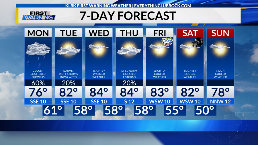 KLBK AM 7-Day Forecast
(Valid: Monday, October 13)(Nexstar Media Inc./EverythingLubbock.com/KLBK News)
• Follow KLBK’s First Warning Weather on Facebook
• Follow KLBK’s First Warning Weather on X
Drought Update:
Areas of the South Plains and Rolling Plains are going into or are already experiencing drought conditions, according to the latest update of the U.S. Drought Monitor (USDM) released on Thursday, October 9.
Two smaller areas of moderate stage (D1) drought conditions and overall abnormally dry (D0) conditions were reported across the Rolling Plains. Abnormally dry (D0) conditions were also reported across roughly the northern quarter and portions of the eastern South Plains.
The USDM data shows drought-free conditions continue to be reported around the immediate Lubbock metro area.
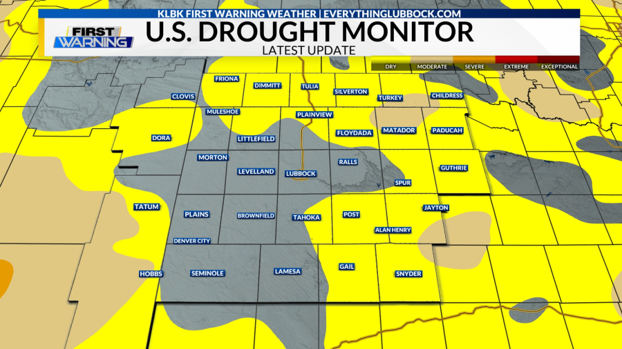 Latest U.S. Drought Monitor Update
(As of Thursday, October 9)(Nexstar Media Inc./EverythingLubbock.com/KLBK News)
• Visit KLBK’s First Warning Weather Center Online
Lubbock Climate Data for Monday, October 13:
Sunrise: 7:51 AM CDT
Sunset: 7:15 PM CDT
Normal High: 77°
Normal Low: 49°
Record High: 92° (1989/1992)
Record Low: 28° (1969)
• Download the “EL+” streaming app to watch KLBK News on Roku, Apple TV & Amazon Fire TV
• Local News Coverage From KLBK News & EverythingLubbock.com
Your KLBK First Warning Forecast:
Today: Mostly cloudy to cloudy and briefly much cooler. Scattered rain showers at times throughout the day for mostly areas. An isolated thunderstorm is also possible. Variable highs ranging from the upper 60s to the middle 80s. South-southeast wind 5-15 mph with gusts up to 20 mph. The chance for rain is 60 percent.
Tonight: Mostly cloudy in the evening and then partly to mostly cloudy overnight. Isolated showers in the evening and overnight across the northwestern areas. Low temperatures ranging from the middle 50s to the middle 60s. East-southeast wind 5-15 mph. The chance for rain is 20 percent.
Tuesday: Mostly sunny to partly cloudy and warmer. Isolated showers and thunderstorms across the northwestern and western areas. Highs ranging from the upper 70s to the upper 80s. South-southeast wind 5-15 mph. The chance for rain is 20 percent.
Have a great week!
Meteorologist Chris Whited
KLBK First Warning Weather
cwhited@klbk13.tv
Facebook: Meteorologist Chris Whited
X: @severewxchaser
Bluesky: severewxchaser