
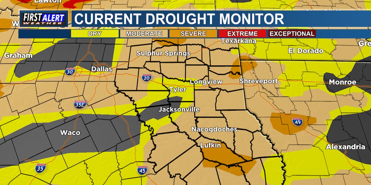
EAST TEXAS (KLTV/KTRE) – Weeks without significant rainfall have intensified drought conditions across East Texas, dropping Sam Rayburn Reservoir to its lowest level since July 2011. Moderate drought is now widespread across East Texas and severe drought continues to develop in parts of the area.
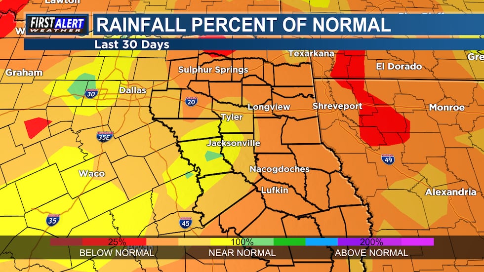 Rainfall % of Normal – Last 30 Days(KLTV)
The moderate drought spreads as negligible rain fell across the area for the last several weeks. Only parts of Anderson, Cherokee, Henderson, and Smith counties are free of dry conditions. The rainfall deficit for parts of East Texas is approaching 1 foot since July 1, and is in the 3 to 4 inch range over the last 30 days. This is 25 to 50% of normal rainfall.
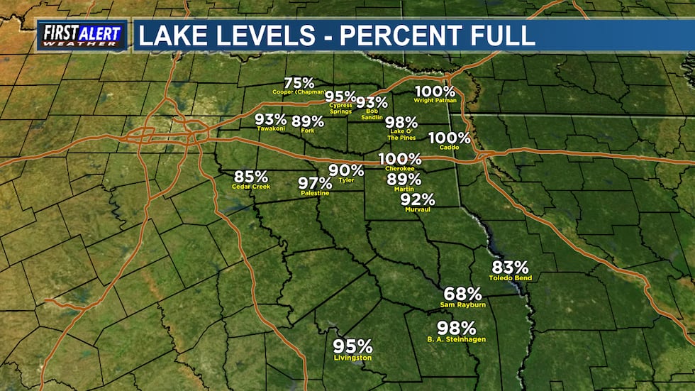 Lake Levels – Percent Full(KLTV)
Notably, severe drought has been prominent in Angelina County since early November and has spread in this week’s update to the Drought Monitor. Sam Rayburn Reservoir and the Angelina River form Angelina County’s eastern border. The reservoir is Texas’s largest lake located entirely within the state. Sam Rayburn dropped from 100% capacity in late May to just 67.6% today. The current water level of 155.17 feet marks the lowest point since July 6, 2011. (Note: The U.S. Army Corps of Engineers lowered the reservoir to a target of 158 feet earlier this year to complete repairs on the dam.)
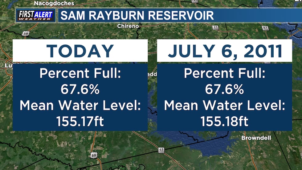 Sam Rayburn Reservoir(KLTV)
Here is the Drought Monitor summary and forecast from the National Drought Mitigation Center for the southern U.S.:
Dry weather occurred across nearly the entire South region this week, which led to widespread degradations in conditions in some states. Warmer-than-normal temperatures occurred in parts of Texas and Oklahoma and some locales in Arkansas, while near- or below-normal temperatures were more common elsewhere. In the Texas Panhandle and southwest parts of the Lone Star State, temperatures of at least 9 degrees above normal were common. South of Oklahoma City, extreme drought developed where ponds dried up amid large short-term precipitation deficits and above-normal evaporative demand. Degradations occurred across large parts of southern Oklahoma where short-term precipitation deficits continued amid above-normal temperatures. A mix of short- and long-term precipitation deficits and warm temperatures led to degradations in southern Texas, while conditions also degraded in parts of north Texas and the Texas Panhandle during recent dry and warm weather. Short-term precipitation deficits also grew in much of northeast Texas, Louisiana, southwest Arkansas and southern Mississippi, leading to degrading conditions. Streamflow and soil moisture levels also were low in some areas that worsened this week.
From the evening of Nov. 19 through Nov. 24, the National Weather Service Weather (NWS) Prediction Center is forecasting a large area to receive near or over 1 inch of precipitation from southern Ohio eastward to northeast Colorado and south to northwest Louisiana and much of Oklahoma and Texas (excluding the southwest). Precipitation amounts of at least 0.75 inches are also forecast in parts of southern California, southern Arizona and southeast two-thirds of New Mexico. Heavy precipitation, locally exceeding 3 inches, is forecast in parts of western Washington. Mostly dry weather is forecast across the northern Great Plains and from the Upper Midwest eastward to most of New York and northern New England. Dry weather is also likely to continue in much of the Southeast, especially in drought-stricken areas of southeast Louisiana, southern Georgia and Florida.
For Nov. 25-29, the NWS Climate Prediction Center forecast favors above-normal precipitation across parts of the northern, central and eastern U.S. The highest confidence areas for above-normal precipitation include the northern Great Plains and the Southeast. Drier-than-normal weather is favored in the Southwest U.S., especially in coastal California, southeast Arizona, southern New Mexico and southwest Texas. The forecast favors colder-than-normal temperatures from northern Washington east to Lake Superior and southward through the central Great Plains. In the West, warmer-than-normal temperatures are likelier from central Oregon southward along the Pacific Coast and eastward to near the Continental Divide. The forecast favors warmer-than-normal temperatures in areas from the Gulf Coast to the Mid-Atlantic, with the highest confidence for warmth centered over the Southeast.
In Hawaii, above-normal temperatures and precipitation are favored across the state. In Alaska, the forecast favors warmer-than-normal temperatures in central and western parts of the state, while southeast Alaska is more likely to be colder than normal. Above-normal precipitation is favored for the southwest part of Alaska, while the forecast leans towards below-normal precipitation in northern and southeast Alaska.
Copyright 2025 KLTV/KTRE. All rights reserved.