
A noisy and very active stretch of weather is underway across Texas as our upper-level storm system moves in from the west. Strong storms, heavy rainfall, localized flooding, hail, and even a few tornadoes will remain possible through tonight and into Monday. Here’s your Sunday afternoon update for November 23, 2025.
Flash Flood Outlook: Sunday Night
The biggest flooding concern tonight continues across the Permian Basin, Big Country, Concho Valley, Northwest Texas, North Texas, and Texoma, where multiple rounds of heavy thunderstorms are expected.
Soils are already saturated, so it will take less rain than normal to cause:
• Street flooding
• Rapid rises on creeks, streams, and small rivers
• Low-lying road flooding, especially in urban areas
Flash Flood Outlook: Monday
By Monday, the flooding risk shifts eastward into:
• North Texas
• Waco and the Brazos Valley
• Northeast Texas and ArkLaTex
• Central and Southeast Texas (isolated risk)
Storms will be moving faster on Monday, which should help limit widespread flooding, but isolated issues are still likely.
Severe Weather Outlook: Sunday Evening and Overnight
Strong to severe storms will continue to develop from late afternoon through the overnight hours across:
• Eastern Trans-Pecos
• Permian Basin
• Concho Valley
• Big Country
• North Texas & Texoma
Primary hazards:
• Large hail (golf ball size or larger possible)
• Strong wind gusts
• A very low—but not zero—tornado threat
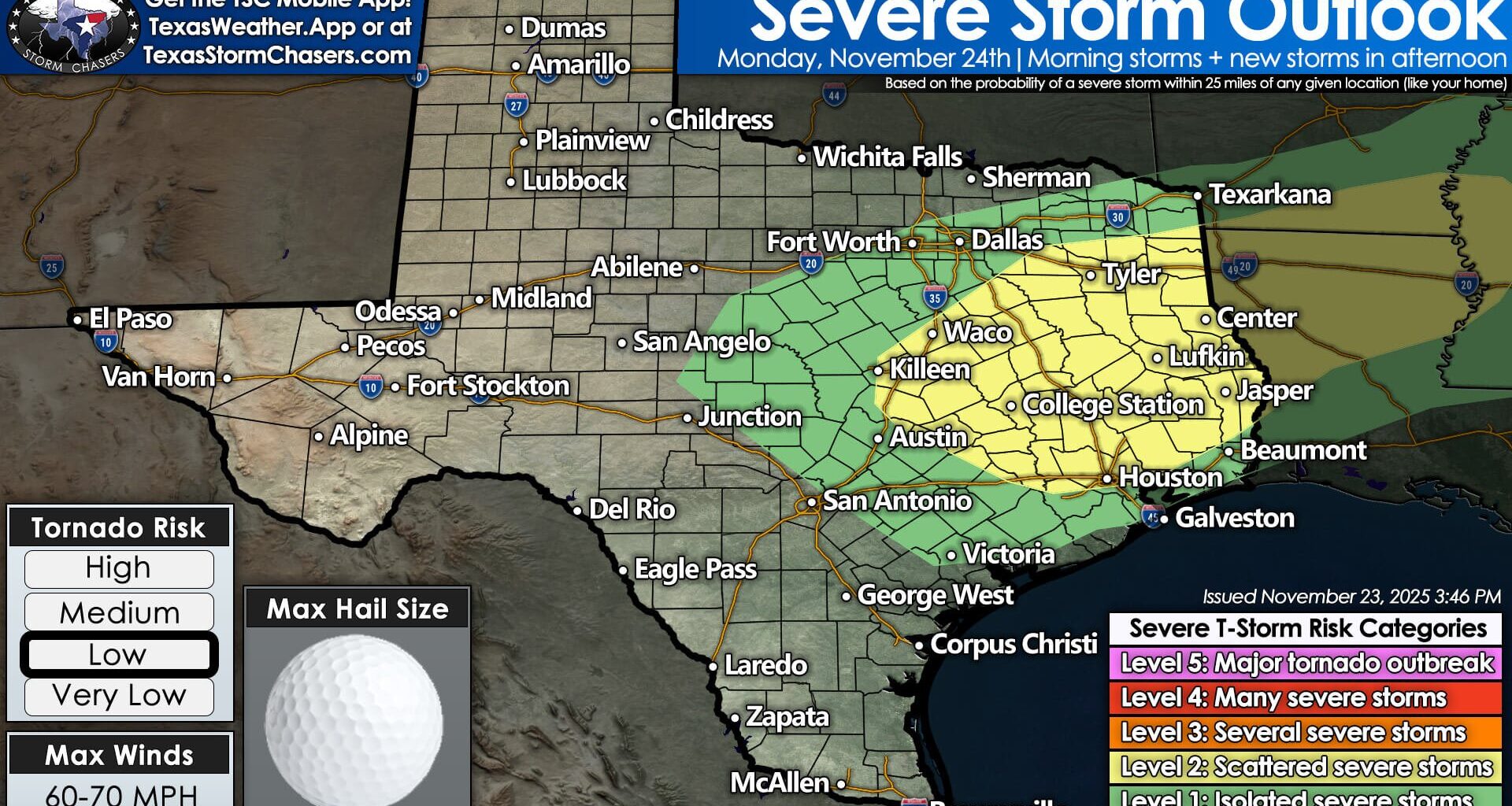
Severe Weather Outlook: Monday
Monday’s storms will bring a higher risk of severe weather, especially in:
• Central Texas
• Northern Brazos Valley
• Northeast Texas
• East Texas
• Southeast Texas (including the Golden Triangle)
Hazards Monday:
• Damaging wind gusts
• Large hail
• A higher tornado threat than today
• Potential for one or two stronger tornadoes if discrete storms develop
We may see parts of East or Southeast Texas upgraded to a Level 3/5 risk depending on Monday’s data.
Storm Timing Overview
Tonight into early Monday morning:
• Widespread storms from Abilene → DFW → Texoma
• Heavy rain with frequent lightning
• DFW Monday morning commute likely to be a washout
Monday afternoon and evening:
• New storms develop in Central, East, and Southeast Texas
• Potential for rotating storms and tornadoes
• Flooding threat continues in areas that saw heavy rain overnight
Monday night:
• Storms finally push into LA/AR and offshore into the Gulf
• Clearing begins late Monday night into Tuesday morning
Quieter Weather By Thanksgiving
After Monday night’s storms exit the region, Texas will enter a quieter and cooler stretch of weather.
Tuesday through Friday looks mostly dry statewide with comfortable temperatures.
Stay Weather Aware
We’ll have continuous updates across:
• YouTube (Texas Storm Chasers)
• TexasStormChasers.com
• The free Texas Storm Chasers mobile app
• Social media platforms
If tornado warnings are issued, we will go live with real-time coverage.
Stay safe, stay informed, and keep an eye on the sky tonight and Monday.