
Chilly weather grips Houston to kick off December
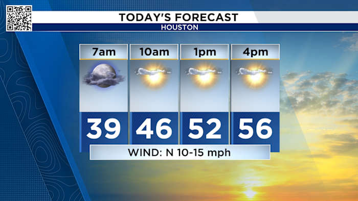
HOUSTON – Get ready for a real taste of winter as chilly air settles into Houston this week. Temperatures are starting out in the mid to upper 30s Tuesday morning across much of the region.
Some spots—like Huntsville and Livingston—may dip close to freezing, while much of the Houston area will wake up to readings from 36 to 38 degrees. Galveston will offer a slightly warmer start around 47 degrees.
Tuesday forecast (Copyright 2025 by KPRC Click2Houston – All rights reserved.)
Despite the cold start, Tuesday is forecast to bring plenty of sunshine. Temperatures are only expected to climb into the mid-50s by the afternoon, keeping things brisk.
For the rest of the workweek, daytime highs should hover in the mid to upper 50s, which is quite a bit lower than the seasonal average of 68 degrees. So, keep those sweaters handy for at least a few more days.
Rain returns midweek, with flood risk near the coast
Houston’s dry spell gets another break this week as rain returns to the forecast. After a crisp Tuesday, clouds are expected to roll back in by Wednesday afternoon. Light showers could start in the evening, with heavier rain possible overnight as a cold front swings through the area.
While the main batch of rain is expected to stay east of Houston, periods of steady showers and isolated thunderstorms are likely, especially from Galveston through Chambers County down towards the Gulf coast.
The KPRC 2 Weather Team says the flash flood risk is expected to remain low and focused along coastal areas, where the heaviest rain bands are forecast to set up.
Most areas in greater Houston can expect rainfall amounts between a half-inch and an inch and a half through Thursday, with higher totals possible closer to the coast. For those tracking precipitation and drought recovery, any additional rain is a welcome sign—even if it means another dreary day.
Have a rain gauge or a dramatic cloud photo? Now’s a great time to share it on Click2Pins—your pictures could be featured on air or online.
Looking ahead: gradual warming by the end of the week
The chilly pattern isn’t expected to last forever. The latest 10-day outlook from KPRC 2’s meteorologist shows another few cold mornings through Saturday, with lows in the upper 30s and 40s. Daytime highs are expected to stay in the 50s through Saturday before a warmer trend arrives.
10-day forecast (Copyright 2025 by KPRC Click2Houston – All rights reserved.)
By Sunday and early next week, temperatures are forecast to rebound, pushing afternoon highs near 70 degrees. Nighttime lows will also moderate into the upper 40s and low 50s. While more rain is possible at intervals through Friday, a mix of sun and clouds takes over heading into the new week.
Stay up to date with the latest changes using Storm Tracker 2 radar and regular updates from the KPRC 2 Weather Team on Click2Houston.
Copyright 2025 by KPRC Click2Houston – All rights reserved.