
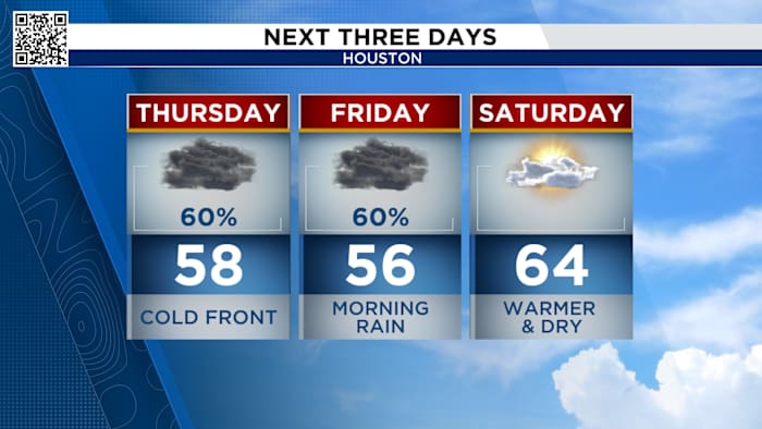
HOUSTON – Thursday Rain Continues:
Roads will likely remain wet and slick for the early morning commute, even if the bulk of the heavier storms have moved east. A good idea is to give yourself some extra time as you head out the door on Thursday.
Spotty to scattered showers across SE Texas during the morning commute
Expect spotty to scattered light showers through Thursday afternoon across SE Texas.
Light rain possible through the late afternoon
Temperatures will remain chilly until Saturday.
Drying out and warming up this weekend
Friday Rain Chances:
Rain chances will continue through Friday with an upper-level disturbance moving across the area. Friday morning’s commute will also likely be messy so plan ahead and the rain will continue through Friday night.
Widespread rain south of I-10A wet commute home
Most areas in greater Houston can expect rainfall amounts between a half-inch and an inch and a half through Thursday, with higher totals possible closer to the coast.
highest near the coast Wednesday and Thursday
Have a rain gauge or a dramatic cloud photo? Now’s a great time to share it on Click2Pins—your pictures could be featured on air or online.
Looking ahead: Gradual warming by the end of the week
The chilly and rainy pattern isn’t expected to last forever. The latest 10-day outlook shows another few cold mornings through Saturday, with lows in the upper 30s and 40s. Daytime highs are expected to stay in the 50s and 60s through Saturday before a warmer trend arrives.
Back to sunshine and 70s next week
Stay up to date with the latest changes using Storm Tracker 2 radar and regular updates from the KPRC 2 Weather Team on Click2Houston.
Copyright 2025 by KPRC Click2Houston – All rights reserved.