
A cold front this weekend could set the stage for the Houston area’s first freeze of the season.
When could temperatures plummet?
The cold front responsible for Houston’s plunging temperatures arrives late Saturday.
This weekend’s front won’t bring lasting cold, but it will usher in low temperatures in the 30s across Southeast Texas by Monday morning. Freezing temperatures are only a concern early Monday, and mainly for communities north of Houston rather than the city itself.
After that, southerly winds take the reins and result in above-normal warmth by the middle of next week.
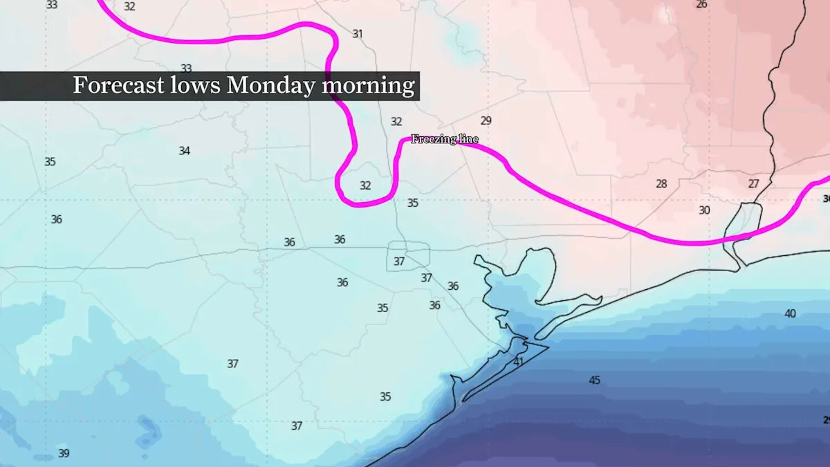
Where are freezing temperatures most likely?
The potential for lows of 32 degrees or colder will mainly be found north and east of Houston.
POLAR VORTEX: How did a stretched polar vortex in late November affect Texas temperatures?
In recent days, data has forecast colder temperatures in areas along the Interstate 10 corridor. While that cooling trend will certainly have to be closely monitored through the weekend, the highest likelihood for freezing temperatures will occur north of Houston. Places like Huntsville to Livingston and Beaumont are most at risk of seeing temperatures drop to 32 degrees.
Temperatures into the mid-30s are possible as far south as Houston and surrounding suburbs, possibly resulting in patchy frost if winds are light enough. Current forecast data suggests wind speeds early Monday morning of 5 to 10 mph would allow for patchy frost development, but slightly higher wind speeds would limit even patchy frost from forming.
How should you prepare?
This potential freeze isn’t expected to cause major issues this far south, and it won’t resemble the severity of the February 2021 deep freeze.
A few simple preparations can help, though: cover outdoor plants or bring them inside before going to bed Sunday. As for pipes, most homes across Southeast Texas are built to withstand temperatures above 24 degrees – the threshold for a “hard freeze” – so it’s unlikely your home’s pipes will be threatened.
When does Houston normally see its first freeze?
On average, Houston records a temperature of 35 degrees or less by Nov. 29, according to weather records that date to 1889. A low of 35 degrees is generally conducive to frost since official temperatures are measured 6 to 10 feet above ground.
A freeze occurs when air temperatures reach 32 degrees or less. Since 1889, Houston has first reached this temperature on Dec. 9. That date shifts two days later when looking at data from the last 25 years.
A hard freeze in Southeast Texas occurs when temperatures fall to 24 degrees or colder for at least two hours. Houston doesn’t often drop to 24 degrees or less in a given winter, though four of the past five winters have brought temperatures as cold as 16 degrees. Since 1889, Houston has averaged a hard freeze on Jan. 8, though that date moves to Jan. 15 since 2000.
This article originally published at Could Houston soon see its first freeze of winter? Here’s the timeline..