
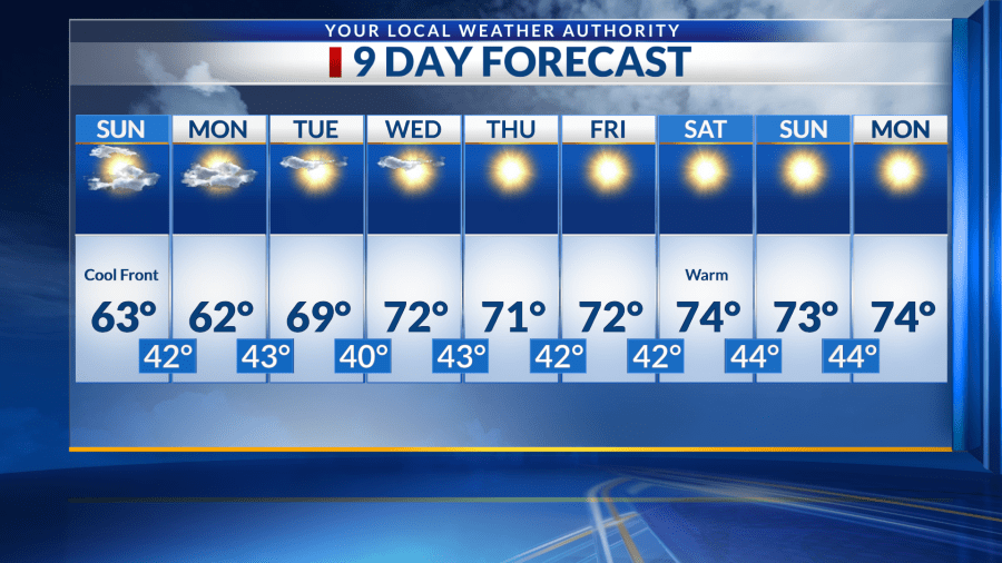
EL PASO, Texas (KTSM) — Happy Saturday, Borderland! Relief from the very warm temperatures will come in Saturday night through a backdoor cold front. The front will produce stronger winds and gusts across the region and drop temperatures closer to average for a couple of days.
Saturday night, partly cloudy skies will be present along with a low in the low 40s. Winds will blow from the northeast around 10-15 mph with gusts nearing 20 mph. These winds will carry over into Sunday morning with speeds calming down in the afternoon hours.
Sunday’s high will warm up to the low 60s. Expect increased cloud cover and occasionally chilly breezes. The low will drop into the low 40s and wind speeds will remain calm.
Monday will be similar conditions with a high in the low 60s and low in the low 40s. In the morning, the winds will be lighter than they were on Sunday.
Tuesday through next Monday, there will be mostly sunny skies as temperatures rebound right back up to well-above-average to be in the upper 60s and low 70s. There’s a chance some of these days will produce record-breaking highs. At this time, there is little to no chance of precipitation. The region will continue to experience dry but calm conditions.
Despite our partly cloudy skies for Saturday, I still recommend bundling up and stepping outside around 8 p.m. MT to try your luck at seeing a meteor. The Geminids meteor shower will peak Saturday night. The annual display will be visible without a telescope or binoculars as long as you’re in a viewing area with low light pollution.
Enjoy the rest of your weekend!
Copyright 2025 Nexstar Media, Inc. All rights reserved. This material may not be published, broadcast, rewritten, or redistributed.
For the latest news, weather, sports, and streaming video, head to KTSM 9 News.